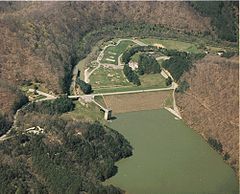
- Dewey Lake
-
Dewey Lake 
Lake and dam Location Floyd County, Kentucky Coordinates 37°44′08″N 82°43′40″W / 37.73556°N 82.72778°WCoordinates: 37°44′08″N 82°43′40″W / 37.73556°N 82.72778°W Lake type reservoir Primary inflows John's Creek Primary outflows John's Creek Basin countries United States Surface area 1,100 acres (4 km2) Dewey Lake, located near Prestonsburg, Kentucky in Floyd County, is part of the integrated flood reduction system operated by the United States Army Corps of Engineers for the entire Ohio River Basin.[1] The 1,100-acre (4 km2) lake was formed by impounding John's Creek in 1949, and was named for either Admiral George Dewey or local resident Dewey Wells.[2]
Jenny Wiley State Resort Park is located on Dewey Lake.
Recreation
The largest tiger muskie ever taken in the state of Kentucky (13 lb., 12 oz.) was caught in Dewey Lake.[3]
References
- ^ "Dewey Lake". United States Army Corps of Engineers. http://www.lrh.usace.army.mil/projects/lakes/DEW/. Retrieved 2007-02-17.
- ^ Kleber, John E., ed (1992). "Lakes". The Kentucky Encyclopedia. Associate editors: Thomas D. Clark, Lowell H. Harrison, and James C. Klotter. Lexington, Kentucky: The University Press of Kentucky. ISBN 0-8131-1772-0.
- ^ "Kentucky State Record Fish List". Kentucky Department of Fish and Wildlife Resources. 2006-04-17. http://fw.ky.gov/recordfish.asp. Retrieved 2007-02-17.
See also
Lakes and reservoirs of Kentucky Lake Barkley · Barren River Lake · Beaver Lake · Boltz Lake · Buckhorn Lake · Bullock Pen Lake · Lake Beshear · Cannon Creek Lake · Lake Carnico · Carr Creek Lake · Cave Run Lake · Cedar Creek Lake · Cranks Creek Lake · Lake Cumberland · Dale Hollow Lake · Dewey Lake · Doe Run Lake · Elk Lake · Elmer Davis Lake · Fishtrap Lake · Grayson Lake · Green River Lake · Greenbo Lake · Guist Creek Lake · Herrington Lake · Kentucky Lake · Kincaid Lake · Laurel River Lake · Lake Linville · Lake Malone · Martins Fork Lake · Nolin River Lake · Paintsville Lake · Pan Bowl Lake · Rough River Lake · Shanty Hollow Lake · Shelby Lake · Swan Lake · Taylorsville Lake · Wilgreen Lake · Williamstown Lake · Willisburg Lake · Wood Creek Lake · Yatesville Lake

Visitor Attractions of the Eastern Mountain Coal Fields Parks StateBuckhorn Lake • Carr Creek • Carter Caves • Cumberland Falls • Dr. Thomas Walker • Fishtrap Lake • Grayson Lake • Greenbo Lake • Jenny Wiley • Kingdom Come • Levi Jackson Wilderness Road • Natural Bridge • Paintsville Lake • Pine Mountain • Pine Mountain Trail • Yatesville Lake
FederalInterstateMuseums Barthell Coal Mining Camp • Bell County Coal House & Museum • Bell County Historical Society Museum • Big Sandy Heritage Center • Blue Heron Coal Mining Camp • Bobby Davis Museum and Park • Breathitt County Museum • C.B. Caudill Store & History Center • Cloverfork Museum • Coal Miners' Museum • Cumberland Inn Museum • David A. Zegeer Coal-Railroad Museum • East Kentucky Science Center • Elkhorn City Railroad Museum • Harland Sanders Café & Museum • Highlands Museum and Discovery Center • Kentucky Coal Mining Museum • Kentucky Folk Art Center • Knox Historical Museum • Magoffin County Pioneer Village and Museum • Marie Stewart Museum & Craft Shop • McCreary County Museum • Morgan County History Museum • Mountain Homeplace • Mountain Life Museum • Northeastern Kentucky Museum • Swamp Valley Museum • U.S. 23 Country Music Highway Museum • Wolfe County History Museum
Forests Daniel Boone • Dewey Lake • Jefferson • Kentenia • Kentucky Ridge • Robinson • Tygarts
Reservoirs Buckhorn Lake • Carr Creek Lake • Cave Run Lake • Cranks Creek Lake • Lake Cumberland • Dewey Lake • Fishtrap Lake • Grayson Lake • Greenbo Lake • Laurel River Lake • Martins Fork Lake • Paintsville Lake • Yatesville Lake
Natural features Black Mountain • Cumberland Falls • Cumberland Gap • Eagle Falls • Middlesboro crater • Pine Mountain • Pound Gap • Raven Rock • Red River Gorge • Tri-State Peak • Yahoo Arch • Yahoo Falls
Miscellaneous Bad Branch Falls State Nature Preserve • Bat Cave and Cascade Caverns State Nature Preserves • Big South Fork Scenic Railway • Black Mountain Off-Road Adventure Area • Cumberland Gap Tunnel • Mayo Mansion • Middle Creek Battlefield • Pikeville Cut-Through • Samuel May House • Sheltowee Trace Trail
Categories:- 1949 establishments
- Buildings and structures in Floyd County, Kentucky
- Geography of Floyd County, Kentucky
- Reservoirs in Kentucky
- U.S. Army Corps of Engineers, Huntington District
- Kentucky geography stubs
Wikimedia Foundation. 2010.


