- Dale Hollow Reservoir
-
Dale Hollow Reservoir 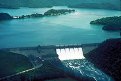
Dam and Lake Location Kentucky / Tennessee Coordinates 36°32′16″N 85°27′05″W / 36.537847°N 85.451317°WCoordinates: 36°32′16″N 85°27′05″W / 36.537847°N 85.451317°W Lake type reservoir Basin countries United States The Dale Hollow Reservoir is a reservoir situated on the Kentucky/Tennessee border. The lake is formed by the damming of the Obey River, 7.3 miles (12 km) above its juncture with the Cumberland River at river mile 380. Portions of the lake also cover the Wolf River. It is also the site of Dale Hollow Lake State Park on the north (Kentucky) side.
Contents
Location
Dale Hollow Reservoir lies mainly in northern Tennessee, where it covers portions of Clay, Pickett, and Overton Counties. Small arms of the lake also extend northward into the Kentucky counties of Cumberland and Clinton. The project consists of 27,700 acres (112 km²) of water and 24,842 acres (101 km²) of surrounding land.
History
The lake takes its name from William Dale, a government surveyor and veteran of the War of 1812. Settling originally in Willow Grove, Mr. Dale bought his first 449 acres (1.8 km²) of land nearby in 1808. The farm eventually grew into a plantation known as Dale Hollow; he and his descendants lived there until the dam was started in 1942. The waters of the lake would ultimately cover both the farm and Willow Grove, “the town that drowned”.
Dale Hollow Dam and Lake was authorized by the Flood Control Act of 1938 and the River and Harbor Act of 1946. The project was completed by the United States Army Corps of Engineers in 1943, making the lake the oldest artificial lake in Kentucky.[1] Hydroelectric power generating units were added in 1948, 1949 and 1953. The project was designed by the Corps of Engineers and built under their supervision by private contractors. The hydroelectric generators of Dale Hollow Dam are used to supply power to the surrounding countryside. The dam, powerplant and reservoir are currently operated by the Nashville District of the Corps.
Recreation
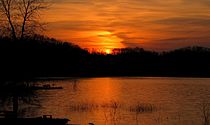 Sunset over Dale Hollow, from the Obey River Campground
The lake is also used recreationally. Water sports are moderately popular, especially water skiing. Wakeboarding and tubing are two more water sports that can be seen regularly. The main recreational use is fishing.
Dale Hollow is well-known as a prime location for smallmouth bass fishing, currently holding the world record for the largest such fish ever taken (11 lb., 15 oz).[2] It is the lake that is linked with the name Billy Westmorland [3], famed smallmouth angler of Celina, Tennessee. The lake and surrounding rivers, the Cumberland River and the Obey River also contain other species such as largemouth bass, crappie, muskellunge, walleye, catfish, gar, and trout.
The Tennessee Wildlife Resources Agency and Kentucky Department of Fish and Wildlife each maintain jurisdiction over the lake's waters within their respective states. There is a reciprocal fishing agreement between the agencies, so recreational fisherman may be licensed by either state in order to fish in the reciprocal zone. Fishermen in areas of the lake outside the zone must be licensed by the governing agency.
See also
- Geiger Island
References
- ^ Kleber, John E., ed (1992). "Lakes". The Kentucky Encyclopedia. Associate editors: Thomas D. Clark, Lowell H. Harrison, and James C. Klotter. Lexington, Kentucky: The University Press of Kentucky. ISBN 0-8131-1772-0.
- ^ "Kentucky State Record Fish List". Kentucky Department of Fish and Wildlife Resources. 2006-04-17. http://fw.ky.gov/recordfish.asp. Retrieved 2007-02-17.
- ^ "Billy Westmorland Tribute to a Champion Angler". Jim Dicken, Fishin.com Editor. http://www.fishin.com/reports/billy/billy2.htm. Retrieved 2007-03-10.
External links
Lakes and reservoirs of Kentucky Lake Barkley · Barren River Lake · Beaver Lake · Boltz Lake · Buckhorn Lake · Bullock Pen Lake · Lake Beshear · Cannon Creek Lake · Lake Carnico · Carr Creek Lake · Cave Run Lake · Cedar Creek Lake · Cranks Creek Lake · Lake Cumberland · Dale Hollow Lake · Dewey Lake · Doe Run Lake · Elk Lake · Elmer Davis Lake · Fishtrap Lake · Grayson Lake · Green River Lake · Greenbo Lake · Guist Creek Lake · Herrington Lake · Kentucky Lake · Kincaid Lake · Laurel River Lake · Lake Linville · Lake Malone · Martins Fork Lake · Nolin River Lake · Paintsville Lake · Pan Bowl Lake · Rough River Lake · Shanty Hollow Lake · Shelby Lake · Swan Lake · Taylorsville Lake · Wilgreen Lake · Williamstown Lake · Willisburg Lake · Wood Creek Lake · Yatesville Lake
 Categories:
- 1943 establishments
- Protected areas of Clay County, Tennessee
- Protected areas of Overton County, Tennessee
- Protected areas of Pickett County, Tennessee
- Reservoirs in Kentucky
- Reservoirs in Tennessee
- Buildings and structures in Clinton County, Kentucky
- Buildings and structures in Cumberland County, Kentucky
- Protected areas of Clinton County, Kentucky
- Protected areas of Cumberland County, Kentucky
- Protected areas of Fentress County, Tennessee


Wikimedia Foundation. 2010.