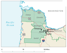
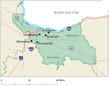
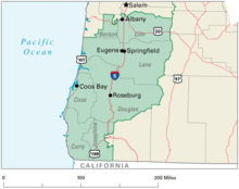
- Oregon's congressional districts
-
The U.S. state of Oregon has had five United States congressional districts since 1982, when the Fifth District was added. Boundaries were redrawn following the population changes to each district as determined by the 1990, 2000, and 2010 Censuses. Although early projections suggested that Oregon might gain a sixth congressional district as a result of the 2010 Census,[1] the state's population was about 42,000 people short of gaining a new district.[2]
Contents
First District
Main article: Oregon's 1st congressional districtDistrict 1 is in the northwest corner of the state and includes some of the Portland metropolitan area. It includes Clatsop County, Columbia County, Washington County, Yamhill County, and part of Multnomah County.
Following the 2010 census, the district boundaries were changed to move Downtown Portland from the 1st to the 3rd district.[3][4]
The district is currently without a Representative due to the resignation of Democrat David Wu.
Second District
Main article: Oregon's 2nd congressional districtDistrict 2 is the largest of Oregon's districts — and the seventh largest district in the nation — covering roughly two-thirds of the state east of the Willamette Valley. It includes all of Baker, Crook, Deschutes, Gilliam, Grant, Harney, Hood River, Jackson, Jefferson, Klamath, Lake, Malheur, Morrow, Sherman, Umatilla, Union, Wallowa, Wasco, Wheeler counties and part of eastern Josephine County, including some of the Grants Pass area.
Following the 2010 census, the district boundaries were changed slightly to move some parts of Grants Pass from the 2nd to the 4th district.[3][4]
The district has been represented by Republican Greg Walden since 1999.
Third District
Main article: Oregon's 3rd congressional districtDistrict 3 covers most of Multnomah County, including Portland east of the Willamette River, and the northern part of Clackamas County.
Following the 2010 census, the district boundaries were changed slightly to add Downtown Portland from the 1st district and southwestern Multnomah County from the 5th district, and move part of Multnomah County near Mount Scott and part of northwestern Clackamas County (including most of the city of Milwaukie) to the 5th district.[3][4]
The district has been represented by Democrat Earl Blumenauer since 1996.
Fourth District
Main article: Oregon's 4th congressional districtDistrict 4 includes the southern half of the coastal counties, including Coos, Curry, Douglas, Lane, and Linn counties and most of Benton and Josephine counties.
Following the 2010 census, the district boundaries were changed slightly to add some parts of Grants Pass from the 2nd district.[3][4]
The district has been represented by Democrat Peter A. DeFazio since 1987.
Fifth District
Main article: Oregon's 5th congressional districtDistrict 5 stretches from the central coast through the state capital into southern suburbs of Portland and part of the summit of Mount Hood. It includes Lincoln County, Marion County, Polk County, Tillamook County, part of Benton County, the southern part of Clackamas County, and a small portion of Multnomah County near Mount Scott.
Following the 2010 census, the district boundaries were changed slightly to add part of Multnomah County near Mount Scott and northwestern Clackamas County (including most of the city of Milwaukie) from the 3rd district, and move southwestern Multnomah County to the 3rd district.[3][4]
The district has been represented by Democrat Kurt Schrader since 2009.
See also
- List of lists about Oregon
- Oregon State Senate, with a map of state senate districts
References
- ^ Brace, Kimball (December 22, 2008). "New Population Estimates Show Slight Changes For 2008 Congressional Apportionment, But Point to Major Changes for 2010". Election Data Services, Inc.. http://www.edssurvey.com/images/File/NR_Appor08wTables.pdf. Retrieved 2008-12-27.
- ^ Saker, Anne (December 21, 2010). "Census shows Oregon's population robust but clearly slowing by 2010". The Oregonian. http://www.oregonlive.com/pacific-northwest-news/index.ssf/2010/12/census_oregons_population_robust_but_clearly_slowing_by_2010.html. Retrieved July 27, 2011.
- ^ a b c d e Mapes, Jeff (June 29, 2011). The Oregonian. http://blog.oregonlive.com/mapesonpolitics/2011/06/oregon_legislators_reach_agree.html title=Oregon legislators reach agreement on congressional redistricting. Retrieved July 27, 2011.
- ^ a b c d e "Oregon's Congressional Districts (Senate Bill 990)". Oregon Legislative Assembly. http://www.leg.state.or.us/redistricting/mapFiles/SB_990_Congressional.pdf. Retrieved July 27, 2011.
External links
- Maps of Oregon congressional districts, from the U.S. Geological Survey
Oregon's congressional districts All districts: Territory At-large 1 2 3 4 5
The At-large and territorial districts are obsolete.
See also: Oregon's past & present Representatives, Senators, and Delegations, 2010 elections, 2012 elections
All U.S. districts – Apportionment – Redistricting – Gerrymandering – MapsCategories:- Congressional districts of Oregon
- Politics of Oregon
Wikimedia Foundation. 2010.


