- Nadezhdinsky District
-
Nadezhdinsky District (English)
Надеждинский район (Russian)
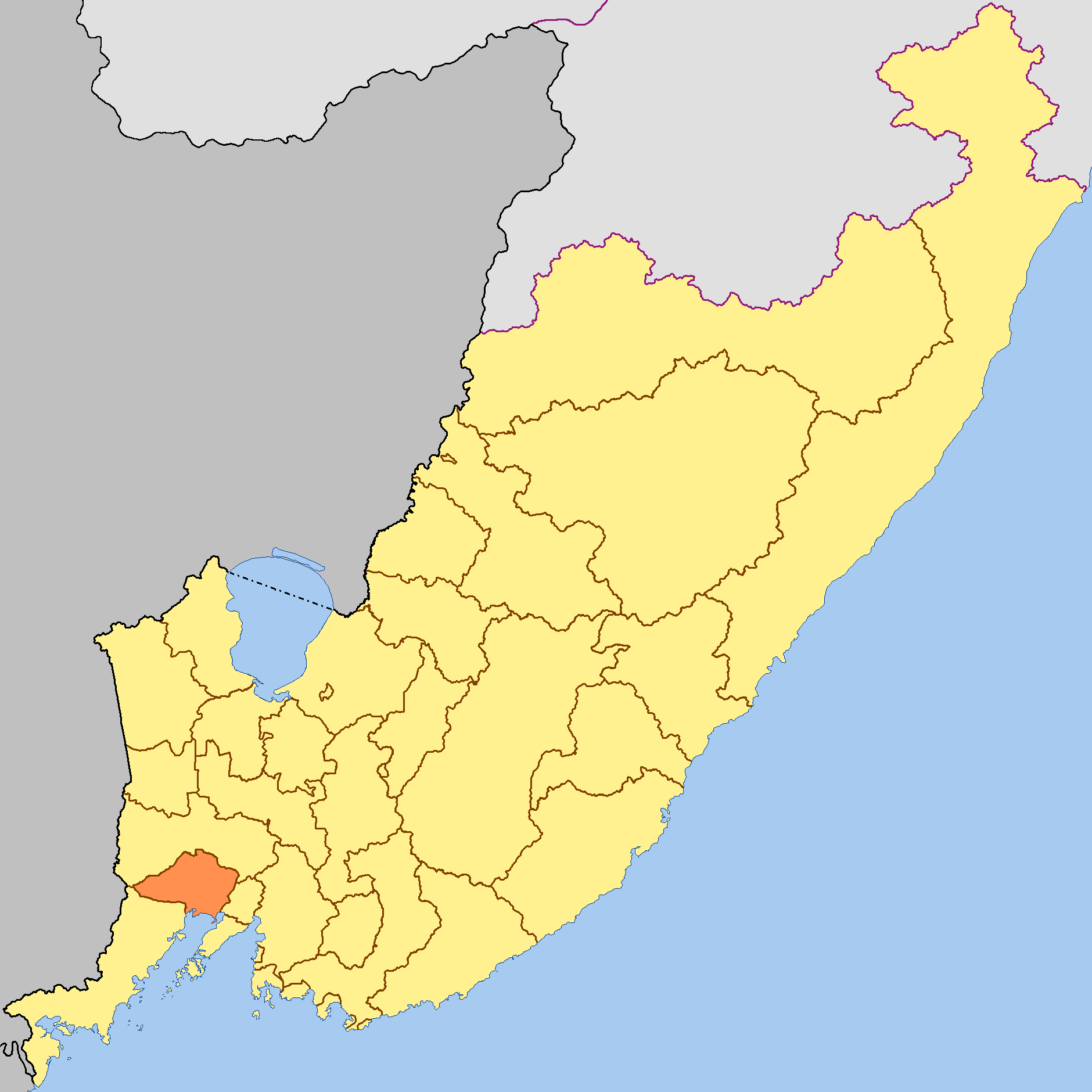
Location of Nadezhdinsky District on the map of Primorsky Krai
Coat of arms Flag Administrative status (as of 2009) Country Russia Federal subject Primorsky Krai[1] Administrative center selo of Volno-Nadezhdinskoye[2] # of rural localities 34[1] Municipal status (as of December 2004) Municipally incorporated as Nadezhdinsky Municipal District[3] - # of rural settlements 3[3] Statistics Area 1,595.7 km2 (616.1 sq mi)[4] Population (2002 Census) 40,197 inhabitants[5] - Urban population 55.7%[6] - Rural population 44.3%[6] Population (2010 est.) 39,317 inhabitants[7] Density 25 /km2 (65 /sq mi)[8] Time zone VLAST (UTC+11:00)[9] Established 1937[2] Official website Nadezhdinsky District (Russian: Наде́ждинский райо́н) is an administrative[1] and municipal[3] district (raion) of Primorsky Krai, Russia; one of the twenty-two in the krai. It is located on the southern coast of the krai. The area of the district is 1,595.7 square kilometers (616.1 sq mi).[4] Its administrative center is the rural locality (a selo) of Volno-Nadezhdinskoye.[2] District's population: 39,317 (2010 est.);[7] 40,197 (2002 Census);[5] 43,012 (1989 Census).[10] Population of Volno-Nadezhdinskoye accounts for 16.8% of the district's population.[5]
The Razdolnaya River crosses the territory of the District.
The favorable climatic conditions and closeness to Vladivostok (the administrative center of the krai) predetermined the district's specialization. There are seven agricultural enterprises which provide Vladivostok with meat, milk, eggs, vegetables, and potatoes. Mink, foxes, polecats, and deer are bred in the district.
For more than a hundred years, the brown coal deposits have been exploited in the territory of the district (Tavrichanskoye Deposit), and construction sand in the Razdolnaya River Valley has been the raw material for silicate brick production. The Razdolnensky Construction Materials Plant, which is one of the district's largest enterprises, is involved in the production of bricks. There are deposits of porous basalt, which is the raw material used by Terekhovsky Concrete Production Plant. Not far from Kiparisovo railway station are beds of sandstone which is the quartz-containing raw materials used by the glass industry. The largest glassworks in Primorsky Krai is located here.
Despite the high density of the population, close location to the large city, and the developed road network, Nadezhdinsky District boasts the unique nature attractions such as the yew (Taxus cuspidata) grove with an area of 400,000 square meters (4,300,000 sq ft), and Korean pine forests.
A federal funded road connects the settlement of Razdolnoye with Khasan, located on the Russian-North Korean border.
References
Notes
- ^ a b c Law #161-KZ, Appendix
- ^ a b c Official website of Nadezhdinsky District. Data About Nadezhdinsky District (Russian)
- ^ a b c Law #182-KZ
- ^ a b Официальный сайт Законодательного Собрания Приморского края. Сборник "Муниципальные образования Приморского края" (Official website of the Legislative Assembly of Primorsky Krai. Municipal Formations of Primorsky Krai) (Russian)
- ^ a b c Федеральная служба государственной статистики (Federal State Statistics Service) (2004-05-21). "Численность населения России, субъектов Российской Федерации в составе федеральных округов, районов, городских поселений, сельских населённых пунктов – районных центров и сельских населённых пунктов с населением 3 тысячи и более человек (Population of Russia, its federal districts, federal subjects, districts, urban localities, rural localities—administrative centers, and rural localities with population of over 3,000)" (in Russian). Всероссийская перепись населения 2002 года (All-Russia Population Census of 2002). Federal State Statistics Service. http://www.perepis2002.ru/ct/doc/1_TOM_01_04.xls. Retrieved 2010-03-23.
- ^ a b The urban/rural distributions are as of the 2002 Census. In 2004, all three urban-type settlements in the district were transformed into rural localities.
- ^ a b Федеральная служба государственной статистики (Federal State Statistics Service). Численность постоянного населения Российской Федерации по городам, посёлкам городского типа и районам на 1 января 2010 г. (Permanent Population of the Russian Federation by Cities/Towns, Urban-Type Settlements, and Districts as of January 1, 2010) (Russian)
- ^ The value of density was calculated automatically by dividing the 2002 Census population by the area specified in the infobox. Please note that this value may not be accurate as the area specified in the infobox does not necessarily correspond to the area of the entity proper or is reported for the same year as the population.
- ^ Правительство Российской Федерации. Постановление №725 от 31 августа 2011 г. «О составе территорий, образующих каждую часовую зону, и порядке исчисления времени в часовых зонах, а также о признании утратившими силу отдельных Постановлений Правительства Российской Федерации». Вступил в силу по истечении 7 дней после дня официального опубликования. Опубликован: "Российская Газета", №197, 6 сентября 2011 г. (Government of the Russian Federation. Resolution #725 of August 31, 2011 On the Composition of the Territories Included into Each Time Zone and on the Procedures of Timekeeping in the Time Zones, as Well as on Abrogation of Several Resolutions of the Government of the Russian Federation. Effective as of after 7 days following the day of the official publication).
- ^ "Всесоюзная перепись населения 1989 г. Численность наличного населения союзных и автономных республик, автономных областей и округов, краёв, областей, районов, городских поселений и сёл-райцентров. (All Union Population Census of 1989. Present population of union and autonomous republics, autonomous oblasts and okrugs, krais, oblasts, districts, urban settlements, and villages serving as district administrative centers.)" (in Russian). Всесоюзная перепись населения 1989 года (All-Union Population Census of 1989). Demoscope Weekly (website of the Institute of Demographics of the State University—Higher School of Economics. 1989. http://demoscope.ru/weekly/ssp/rus89_reg.php. Retrieved 2010-03-23.
Sources
- Законодательное Собрание Приморского края. Закон №161-КЗ от 14 ноября 2001 г. «Об административно-территориальном устройстве Приморского края», в ред. Закона №816-КЗ от 6 октября 2011 г «О внесении изменений в приложение к Закону Приморского края "Об административно-территориальном устройстве Приморского края"». Вступил в силу со дня официального опубликования. Опубликован: "Красное знамя Приморья", №69 (119), 29 ноября 2001 г. (Legislative Assembly of Primorsky Krai. Law #161-KZ of November 14, 2001 On the Administrative-Territorial Structure of Primorsky Krai, as amended by the Law #816-KZ of October 6, 2011 On Amending the Appendix of the Law of Primorsky Krai "On the Administrative-Territorial Structure of Primorsky Krai". Effective as of the official publication date).
- Законодательное Собрание Приморского края. Закон №182-КЗ от 6 декабря 2004 г. «О Надеждинском муниципальном районе». Вступил в силу со дня официального опубликования. Опубликован: "Ведомости Законодательного Собрания Приморского края", №76, 7 декабря 2004 г. (Legislative Assembly of Primorsky Krai. Law #182-KZ of December 6, 2004 On Nadezhdinsky Municipal District. Effective as of the day of the official publication).
Administrative divisions of Primorsky Krai Cities and towns Arsenyev · Artyom · Bolshoy Kamen · Dalnegorsk · Dalnerechensk · Fokino · Lesozavodsk · Nakhodka · Partizansk · Spassk-Dalny · Ussuriysk
Urban-type settlements Dunay · Gornorechensky · Gorny · Gornye Klyuchi · Kavalerovo · Khasan · Khrustalny · Kirovsky · Kraskino · Lipovtsy · Luchegorsk · Novoshakhtinsky · Olga · Plastun · Pogranichny · Posyet · Preobrazheniye · Primorsky · Putyatin · Rudny · Shkotovo · Sibirtsevo · Slavyanka · Smolyaninovo · Svetlaya · Terney · Vostok · Vysokogorsk · Yaroslavsky · ZarubinoDistricts Anuchinsky · Chernigovsky · Chuguyevsky · Dalnerechensky · Kavalerovsky · Khankaysky · Khasansky · Khorolsky · Kirovsky · Krasnoarmeysky · Lazovsky · Mikhaylovsky · Nadezhdinsky · Oktyabrsky · Olginsky · Partizansky · Pogranichny · Pozharsky · Shkotovsky · Spassky · Terneysky · YakovlevskyCategories:- Districts of Primorsky Krai
- States and territories established in 1937
Wikimedia Foundation. 2010.