- Artyom, Russia
-
For other uses, see Artyom (disambiguation).
Artyom (English)
Артём (Russian)- City[citation needed] -
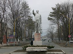
A monument to Vladimir Lenin in ArtyomCoordinates: 43°22′50″N 132°11′12″E / 43.38056°N 132.18667°ECoordinates: 43°22′50″N 132°11′12″E / 43.38056°N 132.18667°E Coat of arms Flag City Day Last Sunday of August[citation needed] Administrative status Country Russia Federal subject Primorsky Krai Administratively subordinated to Artyom City Under Krai Jurisdiction[citation needed] Municipal status Urban okrug Artyomovsky Urban Okrug[1] Head[citation needed] Vladimir Novikov[citation needed] Representative body Duma[citation needed] Statistics Area 506 km2 (195 sq mi)[citation needed] Population (2010 Census,
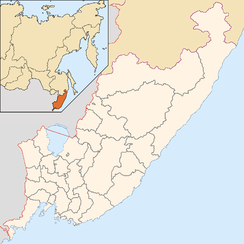
preliminary)102,600 inhabitants[2] - Rank in 2010 159th Population (2002 Census) 64,145 inhabitants[3] - Rank in 2002 250th Density 203 /km2 (530 /sq mi)[4] Time zone VLAST (UTC+11:00)[5] Founded 1924[6] Dialing code(s) +7 42337[citation needed] Official website Artyom (Russian: Артём) is a city in Primorsky Krai, Russia, situated in the northern part of the Muravyov-Amursky Peninsula. Population: 102,600 (2010 Census preliminary results);[2] 64,145 (2002 Census);[3] 68,887 (1989 Census).[7]
Artyom is built mainly with one-, two-, and five-story panel buildings, though a comparatively large number of wooden private houses can be seen.
History
Artyom was founded in 1924 near the Zybunny pit mine, named after revolutionary Fyodor Sergeyev who was better known by his nickname Artyom. On October 26, 1938, it was granted town status. In 2004, the amalgamation of surrounding former urban-type settlements Uglovoye, Zavodskoy, and Artyomovsky into the city saw its official population rise from around 60,000 to over 100,000.
Business and industry
Half of the able-bodied population of Artyom is engaged in the production of materials.
Artyom has 29 industrial enterprises, half of which are private. Among the consumer goods produced in the town are furniture, china, sewing production. The companies employing the largest number of workers in Artyom are Primorskoye Mine Administration (3,500 people) and Artyom-Mebel Furniture Factory (1,100 people). Fifteen joint ventures have been registered in Artyom.
Coal mining, an industry without future, has always been the basis of the local economy. Coal reserves have practically been exhausted. The forecasts are that transport will be the most productive industry for Artyom's economic development.
Vladivostok International Airport is located near Artyom. The largest Primorsky Krai railroad junction is also found here. Annually, 12 million tons of cargo pass through Artyom to Vladivostok, and 24 million tons to Nakhodka. In 1994, the airport served 500,000 passengers. This number represented no more than 28% of its potential.
References
- ^ Законодательное Собрание Приморского края. Закон №157-КЗ от 10 ноября 2004 г. «Об Артёмовском городском округе». Вступил в силу с 1 января 2005 г. Опубликован: "Ведомости Законодательного Собрания Приморского края", №72, 11 ноября 2004 г. (Legislative Assembly of Primorsky Krai. Law #157-UZ of November 10, 2004 On Artyomovsky Urban Okrug. Effective as of January 1, 2005).
- ^ a b Федеральная служба государственной статистики (Federal State Statistics Service) (2011). "Предварительные итоги Всероссийской переписи населения 2010 года (Preliminary results of the 2010 All-Russian Population Census)" (in Russian). Всероссийская перепись населения 2010 года (All-Russia Population Census of 2010). Federal State Statistics Service. http://www.perepis-2010.ru/results_of_the_census/results-inform.php. Retrieved 2011-04-25.
- ^ a b Федеральная служба государственной статистики (Federal State Statistics Service) (2004-05-21). "Численность населения России, субъектов Российской Федерации в составе федеральных округов, районов, городских поселений, сельских населённых пунктов – районных центров и сельских населённых пунктов с населением 3 тысячи и более человек (Population of Russia, its federal districts, federal subjects, districts, urban localities, rural localities—administrative centers, and rural localities with population of over 3,000)" (in Russian). Всероссийская перепись населения 2002 года (All-Russia Population Census of 2002). Federal State Statistics Service. http://www.perepis2002.ru/ct/doc/1_TOM_01_04.xls. Retrieved 2010-03-23.
- ^ The value of density was calculated automatically by dividing the 2010 Census population by the area specified in the infobox. Please note that this value may not be accurate as the area specified in the infobox does not necessarily correspond to the area of the entity proper or is reported for the same year as the population.
- ^ Правительство Российской Федерации. Постановление №725 от 31 августа 2011 г. «О составе территорий, образующих каждую часовую зону, и порядке исчисления времени в часовых зонах, а также о признании утратившими силу отдельных Постановлений Правительства Российской Федерации». Вступил в силу по истечении 7 дней после дня официального опубликования. Опубликован: "Российская Газета", №197, 6 сентября 2011 г. (Government of the Russian Federation. Resolution #725 of August 31, 2011 On the Composition of the Territories Included into Each Time Zone and on the Procedures of Timekeeping in the Time Zones, as Well as on Abrogation of Several Resolutions of the Government of the Russian Federation. Effective as of after 7 days following the day of the official publication).
- ^ Энциклопедия Города России. Moscow: Большая Российская Энциклопедия. 2003. p. 25. ISBN 5-7107-7399-9.
- ^ "Всесоюзная перепись населения 1989 г. Численность наличного населения союзных и автономных республик, автономных областей и округов, краёв, областей, районов, городских поселений и сёл-райцентров. (All Union Population Census of 1989. Present population of union and autonomous republics, autonomous oblasts and okrugs, krais, oblasts, districts, urban settlements, and villages serving as district administrative centers.)" (in Russian). Всесоюзная перепись населения 1989 года (All-Union Population Census of 1989). Demoscope Weekly (website of the Institute of Demographics of the State University—Higher School of Economics. 1989. http://demoscope.ru/weekly/ssp/rus89_reg.php. Retrieved 2010-03-23.
Administrative divisions of Primorsky Krai Administrative center: Vladivostok Cities and towns Arsenyev · Artyom · Bolshoy Kamen · Dalnegorsk · Dalnerechensk · Fokino · Lesozavodsk · Nakhodka · Partizansk · Spassk-Dalny · Ussuriysk
Urban-type settlements Dunay · Gornorechensky · Gorny · Gornye Klyuchi · Kavalerovo · Khasan · Khrustalny · Kirovsky · Kraskino · Lipovtsy · Luchegorsk · Novoshakhtinsky · Olga · Plastun · Pogranichny · Posyet · Preobrazheniye · Primorsky · Putyatin · Rudny · Shkotovo · Sibirtsevo · Slavyanka · Smolyaninovo · Svetlaya · Terney · Vostok · Vysokogorsk · Yaroslavsky · ZarubinoDistricts Anuchinsky · Chernigovsky · Chuguyevsky · Dalnerechensky · Kavalerovsky · Khankaysky · Khasansky · Khorolsky · Kirovsky · Krasnoarmeysky · Lazovsky · Mikhaylovsky · Nadezhdinsky · Oktyabrsky · Olginsky · Partizansky · Pogranichny · Pozharsky · Shkotovsky · Spassky · Terneysky · YakovlevskyCategories:- Cities and towns in Primorsky Krai
- Cities and towns built in the Soviet Union
- Populated places established in 1924
Wikimedia Foundation. 2010.


