- Missinaibi River
-
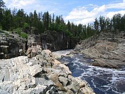
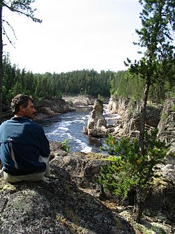
Missinaibi River Thunderhouse FallsCountry Canada Province Ontario Region Algoma District, Cochrane District Source Missinaibi Lake - location 12 km SSW from Peterbell inside the Chapleau Crown Game Preserve, Algoma District - coordinates 48°29′56″N 83°25′52″W / 48.49889°N 83.43111°W Mouth Moose River - location Unorg. Cochrane District - coordinates 50°44′08″N 81°28′02″W / 50.73556°N 81.46722°W Length 426 km (265 mi) [1] Basin 23,500 km2 (9,100 sq mi) [1] The Missinaibi River is a river in northern Ontario, Canada, which flows northeast from Missinaibi Lake, north of Chapleau, and empties into the Moose River, which drains into James Bay. This river (including Missinaibi Lake and Moose River to James Bay) is 755 kilometres (469 mi) in length.[2] It is one of the longest free-flowing and undeveloped rivers in Ontario.[3]
The river's name means "pictured waters" in the Cree language which is thought to refer to the pictographs found on rock faces along the river.
At Thunderhouse Falls, which is actually a chain of relatively small waterfalls connected by violent rapids, the river drops 40 metres, part of its descent from the Canadian Shield to the Hudson Bay Lowlands.
Contents
History
In the days of the fur trade, this river provided access to James Bay by way of the Moose River and to Lake Superior by way of the Michipicoten River. There is also evidence that native peoples used the river as a trading route long before that time. This route was used by traders from both the Hudson's Bay Company and the North West Company. A number of trading posts were built along the river in the late 18th century and the fur trade continued until the late 19th century.
Today, the river is used for canoeing, fishing and camping. Recreational use is facilitated by an arrangement which allows canoeists to load their boats on a train so they can be returned south, after canoeing the wild stretches of the river. The river is managed as a provincial waterway park and was designated as a Canadian Heritage River in 2004.
Tributaries
- Brunswick River
- Fire River
- Hay River
- Mattawitchewan River
- Albany Forks
- Oba River, Oba Lake
- Albany Forks
- Pivabiska River
- Opasatika River
- Soweska River
Missinaibi Provincial Park
Missinaibi Provincial Park IUCN Category II (National Park)Location Ontario, Canada Nearest city Mattice Area 990.90 square kilometres (382.59 sq mi) Established 1970, enlarged in 1989 Governing body Ontario Parks The entire length of the Missinaibi River from Missinaibi Lake to the Moose River is protected and part of the Missinaibi Provincial Park. The park also includes Missinaibi Lake, Brunswick River, Brunswick Lake, Little Missinaibi River, and Little Missinaibi Lake.
See also
- List of Ontario rivers
- James Bay Rivers
External links
- Ontario Parks - Missinaibi Prov. Park official website
- Snow Falling on Black Spruce- A Northern Ontario Canoe Sojourn Down the Missinaibi
- Missinaibi Complete - Missinaibi canoe trip July 1-22, 2004
References
- ^ a b Atlas of Canada
- ^ Wilson, Hap (1994). Missinaibi - Journey to the Northern Sky. pp. 45 60 122. ISBN 1-895465-08-7.
- ^ "Missinaibi". Ontario Parks. 2008-05-09. http://www.ontarioparks.com/english/miss.html. Retrieved 2009-06-04.
Canadian Heritage Rivers System 
Rivers Alsek • Arctic Red • Athabasca • Bay du Nord • Bloodvein • Bonnet Plume • Boundary Waters • Clearwater • Cowichan • Detroit • Fraser • French • Grand • Hayes • Hillsborough • Humber • Kazan • Kicking Horse • Main • Margaree • Mattawa • Missinaibi • North Saskatchewan • Red • Rideau • Seal • Shelburne • Soper • South Nahanni • St. Croix • St. Marys • Tatshenshini • Thames • Thelon • The Three Rivers • Upper Restigouche • YukonNominated See also: American Heritage Rivers • Category:American Heritage Rivers • Category:Canadian Heritage Rivers • Category:Rivers of Canada Categories:- IUCN Category II
- Canadian Heritage Rivers
- Rivers of Ontario
- Hudson's Bay Company trading posts
Wikimedia Foundation. 2010.


