- Moose River (Ontario)
-
Moose River 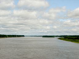
Country Canada Province Ontario Region Cochrane District Source confluence Mattagami and Missinaibi Rivers - location Unnamed wilderness of Unorg. Cochrane District - coordinates 50°44′08″N 81°28′02″W / 50.73556°N 81.46722°W Mouth James Bay - location 17 km NE from Moosonee - coordinates 51°21′02″N 80°23′57″W / 51.35056°N 80.39917°W Length 104 km (65 mi) [1] Basin 108,500 km2 (41,900 sq mi) [1] Discharge - average 1,370 m3/s (48,380 cu ft/s) [1] 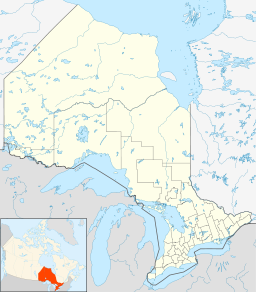
 Location of the mouth of the Moose River in Ontario.
The Moose River is a Canadian river in the Hudson Plains ecozone of northern Ontario which flows 100 km northeast from the junction of the Mattagami and Missinaibi Rivers into James Bay. Its drainage basin is 108,500 km² and it has a mean discharge rate of 1370 m³/s. Its full length is 547 kilometres (340 mi) if counted from the head of the Mattagami River. [1]
This river formed part of the water route to Lake Superior in the days of the fur trade. Moose Factory, located on Moose Factory Island near the river's mouth, was a fur trading post of the Hudson's Bay Company and Ontario's first English settlement. Moosonee, Ontario, on the north bank of the river, is the northern terminus of the Polar Bear Express railway route which begins at Cochrane, Ontario.
Contents
Tributaries
The tributaries of this river include:
- Kwataboahegan River
- Cheepash River
- Abitibi River
- Frederick House River
- Mattagami River
- Kapuskasing River
- Nemegosenda River
- Chapleau River
- Nemegosenda River
- Groundhog River
- Ivanhoe River
- Nat River
- Kapuskasing River
- Missinaibi River
- Brunswick River
- Fire River
- Hay River
- Mattawitchewan River
- Albany Forks
- Oba River, Oba Lake
- Albany Forks
- Pivabiska River
- Opasatika River
- Soweska River
Moose River Bird Sanctuary
Moose River Bird Sanctuary lies at the mouth of the Moose River and comprises Ship Sands Island and a piece of land on the eastern flats of the river mouth. The 14.60 km² sanctuary is protected under the Migratory Birds Convention Act and is part of the Southern James Bay wetland complex, which was designated a wetland of international importance (Ramsar Convention) in May 1987.
This area plays a significant role in the annual cycle of waterfowl. The funnel-shaped outline of Hudson and James bays causes birds migrating from the Arctic to concentrate at the southern end of James Bay each autumn, particularly in the late autumn, where the extensive coastal wetlands provide critical staging and moulting areas for migrating Lesser Snow Geese, dabbling ducks and shorebirds such as Red Knot, Short-billed Dowitcher, Dunlin, Greater Yellowlegs, Lesser Yellowlegs, Ruddy Turnstone, and American Golden Plover.[2]
Settlement of Moose River
At mile 142 of the Polar Bear Express railway route there is a small settlement called Moose River. This settlement is just before a large railway bridge that crosses Moose River and is a flag stop on the Polar Bear Express rail route. There is an Ontario Northland Railway bunkhouse that used to be a school. The Moose River bridge was built in the 1930s and the settlement was a much larger community at that time. Currently the Moose River stop at mile 142 is used for the residents of the settlement and as a pick-up and drop-off site for boaters.
See also
References
Categories:- Rivers of Ontario
- Bird sanctuaries of Canada
- Tributaries of James Bay
- Northern Ontario geography stubs


Wikimedia Foundation. 2010.