- McKenzie, North Dakota
-
McKenzie, North Dakota — Township — Location within the state of North Dakota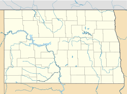
 McKenzie, North Dakota
Coordinates: 46°49′20″N 100°24′55″W / 46.82222°N 100.41528°WCoordinates: 46°49′20″N 100°24′55″W / 46.82222°N 100.41528°W Country United States State North Dakota County Burleigh Area - Total 35.9 sq mi (93.1 km2) - Land 35.9 sq mi (93.0 km2) - Water 0.1 sq mi (0.2 km2) Elevation 1,749 ft (533 m) Population (2000) - Total 83 - Density 2.3/sq mi (0.9/km2) Time zone Central (CST) (UTC-6) - Summer (DST) CDT (UTC-5) ZIP code 58572 Area code(s) 701 FIPS code 38-49380[1] GNIS feature ID 1759339[2] McKenzie is an unincorporated community in Burleigh County, North Dakota, United States. It lies about 20 miles east of Bismarck along I-94/US 83. The community was named after early North Dakota politician Alexander McKenzie. McKenzie's ZIP code is 58572.
References
- ^ "American FactFinder". United States Census Bureau. http://factfinder.census.gov. Retrieved 2008-01-31.
- ^ "US Board on Geographic Names". United States Geological Survey. 2007-10-25. http://geonames.usgs.gov. Retrieved 2008-01-31.
Municipalities and communities of Burleigh County, North Dakota County seat: Bismarck Cities 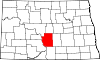
Townships Apple Creek | Boyd | Canfield | Christiania | Clear Lake | Crofte | Cromwell | Driscoll | Ecklund | Estherville | Florence Lake | Francis | Ghylin | Gibbs | Glenview | Grass Lake | Harriet-Lien | Hay Creek | Hazel Grove | Logan | Long Lake | McKenzie | Menoken | Missouri | Morton | Naughton | Painted Woods | Richmond | Rock Hill | Schrunk | Sibley Butte | Steiber | Sterling | Taft | Telfer | Thelma | Trygg | Wild Rose | Wilson | Wing
CDPs Unorganized
territoriesBurnt Creek-Riverview | Lincoln-Fort Rice | Lyman | Phoenix
Unincorporated
communitiesFootnotes ‡This populated place also has portions in an adjacent county or counties
 Bismarck-Mandan Metropolitan Area (ND)
Counties Core city Surrounding areas †-county seat Categories:- Unincorporated communities in North Dakota
- Populated places in Burleigh County, North Dakota
- North Dakota geography stubs


Wikimedia Foundation. 2010.