- Blaengwrach
-
 Blaengwrach
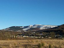
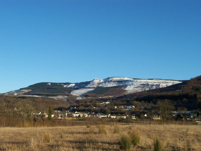
Blaengwrach (pronounced /blaɪn.ˈɡrɑːx/ blyn-grahkh)[1][2] is a village near Glynneath and Resolven in the county borough of Neath Port Talbot, Wales. It is also the name of a community and an electoral ward of Neath Port Talbot county borough. There are, however, some differences between the boundaries of the community and the ward. The ward had a population of 1,985 in the 2001 census, but 837 of these were actually residents of the neighbouring community of Glynneath and so the population of the Blaengwrach community itself would have been 1,148.
Blaengwrach is a predominantly upland area, and contains the highest points of three local hills or mountains, namely Mynydd Resolfen (383mt/1257 ft) and the rather more impressive Mynydd Pen-y-Cae (573mt/1880 ft) and Craig-y-Llyn (600mt/1970 ft), both of which offer spectacular views of the valley below and the Brecon Beacons in the distance. Craig-y-Llyn is the highest point in the old county of Glamorgan, and is home to a nature reserve containing Llyn Fach and a Site of Special Scientific Interest.
The village of Blaengwrach is often confused with the settlement of Cwmgwrach. Traditionally, the two are settlements separated by a stream or brook running through the middle of them. However, the sign welcoming you to Cwmgwrach is actually in Blaengwrach, and in similar fashion, Blaengwrach school is actually in Cwmgwrach, although this could be explained by its being named after the wider ward. In reality the residents call the entire village Cwmgwrach, with Blaengwrach being best used as the name for the wider area in which the village is situated. A history of the village (Cwmgwrach: Valley of the Witch) was written by Ian Currie. Huw Pudner and Chris Hastings have written a folk song called 'Selar Hill' which is about the open cast mining on Selar Hill above the village of Cwmgwrach.
The village itself contains various local shops, pubs and a rugby union club, Cwmgwrach RFC. However, for wider services the village is largely dependent upon Glynneath.
Government and politics
Blaengwrach Ordnance Survey OS grid reference: Maps for SN868052 Geography Total population 1,987 (2001 census) Administration Local council: Neath Port Talbot County Borough Council Number of councillors]: 1 Nation: Wales Post office and telephone Postcode(s): SA11 Dialling code: +44-1639 Politics Welsh Assembly: Neath UK Parliament: Neath European Parliament: Wales The electoral ward of Blaengwrach includes part or all of the villages of Blaengwrach and Cwmgrach in the parliamentary constituency of Neath. The Blaengwrach ward is bounded by the wards of Glynneath to the north; Rhigos of Rhondda Cynon Taff to the east; Glyncorrwg to the south; and Resolven to the southwest. The ward consists of a built up settlement to the northwest. The central area is dominated by open cast coal mining, while the rest of the ward is ringed by woodlands and forests.
In the 2008 local council elections, the electorate turnout was 51.42%. The results were:
Candidate Party Votes Status Alf Siddley Labour 432 Labour gain Carolyn Edwards Plaid 380 References
- ^ John Wells's Phonetics Blog
- ^ G.M. Miller, BBC Pronouncing Dictionary of British Names (Oxford UP, 1971), p. 16; "Welsh speakers pronounce 'gwrach' as one syllable by treating the 'w' as a rounding of the lips to accompany the 'r'," which also occurs with English /r/.
External links
- www.geograph.co.uk Photos of Blaengwrach and surrounding area
- Cwmgwrach Public Cemetery transcripts and images
- St. Mary's Church, Blaengwrach, transcripts and images
Neath Port Talbot Communities Aberavon · Baglan Bay · Blaengwrach · Blaenhonddan · Briton Ferry · Bryn · Cilybebyll · Clyne · Coedffranc · Crynant · Cwmavon · Cwmllynfell · Dyffryn Clydach · Glyncorrwg · Glynneath · Gwaun-cae-Gurwen · Margam · Margam Moors · Neath · Onllwyn · Pelenna · Pontardawe · Port Talbot · Resolven · Sandfields East · Sandfields West · Seven Sisters · Tai Bach · Tonna · Ystalyfera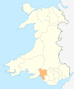
Towns and villages Aberavon · Aberdulais · Abergarwed · Alltwen · Baglan · Blaengwrach · Blaenhoddan · Cadoxton · Cilfrew · Cilybebyll · Clyne · Cwmgors · Cwmllynfell · Crynant · Glynneath · Godre'r Graig · Goytre · Groes · Llangiwg · Lonlas · Lower Brynamman · Margam · Melincourt Falls · Morfa Glas · Neath · Pontardawe · Port Talbot · Resolven · Rhiwfawr · Rhydyfro · Seven Sisters · Skewen · Tairgwaith · Tonna · YstalyferaCastles Rivers Electoral wards of Neath Port Talbot county borough Aberavon Neath Aberdulais · Allt-Wen · Blaengwrach · Bryncoch North · Bryncoch South · Cadoxton · Cimla · Crynant · Cwmllynfell · Dyffryn · Glynneath · Godre'r Graig · Gwaun-Cae-Gurwen · Lower Brynamman · Neath East · Neath North · Neath South · Onllwyn · Pelenna · Pontardawe · Resolven · Rhos · Seven Sisters · Tonna · Trebanos · Ystalyfera
Communities of Neath Port Talbot county borough Aberavon · Baglan · Baglan Bay · Blaengwrach · Blaenhonddan · Briton Ferry · Bryn · Cilybebyll · Clyne and Melincourt · Coedffranc · Crynant · Cwmafan · Cwmllynfell · Dyffryn Clydach · Glyncorrwg · Glynneath · Gwaun-Cae-Gurwen · Margam · Margam Moors · Neath · Onllwyn · Pelenna · Pontardawe · Port Talbot · Resolven · Sandfields East · Sandfields West · Seven Sisters · Taibach · Tonna · Ystalyfera
Categories:- Vale of Neath
- Villages in Neath Port Talbot
- Electoral wards of Neath Port Talbot
- Communities in Neath Port Talbot

Wikimedia Foundation. 2010.