- Cilybebyll
-
Coordinates: 51°43′08″N 3°49′48″W / 51.719°N 3.830°W
Cilybebyll 
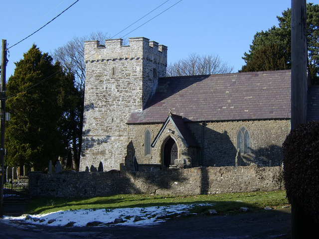
St John the Evangelist's church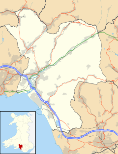
 Cilybebyll
Cilybebyll shown within Neath Port TalbotPopulation 4,806 (2001) OS grid reference SN7404 Community Cilybebyll Principal area Neath Port Talbot Ceremonial county West Glamorgan Country Wales Sovereign state United Kingdom Post town SWANSEA Dialling code 01792 Police South Wales Fire Mid and West Wales Ambulance Welsh EU Parliament Wales UK Parliament Neath Welsh Assembly Neath List of places: UK • Wales • Neath Port Talbot Cilybebyll /ˌkɪləˈbɛbɪɬ/ is a village and community in Neath Port Talbot County Borough in Wales. It includes the villages of Alltwen, Fforest Gôch, Gellinudd and Rhos, and is located 1.9 miles (3.1 km) east of Pontardawe, 4.7 miles (7.6 km) north of Neath and 10.3 miles (16.6 km) north east of Swansea. The community has a population of 4,806.[1]
The Cilybebyll estate was established in the 15th century,[2] and after development by various families, by 1838 was recorded as having the largest land holding in the district. The main house, Plas Cilybebyll, was redeveloped in 1840 by Henry Leach, creating a south-facing Victorian facade on the property. His son Frances Edward Leach inherited the estate in 1848, changing his name to Lloyd in 1849 by Royal Charter in order not to forfeit his inheritance. The family remained in residence until the early 20th century, when the family records were passed to Swansea Museum. The main house today is a guest house.
On 15 September 2011, water poured into the mine workings at Gleision Colliery. Three miners escaped to the surface, with one taken to Morriston Hospital. Units from the Mines Rescue Service were called in from across the United Kingdom, to rescue four men located 90 metres (300 ft) below the surface.[3] Four bodies were subsequently found. Parallel inquiries into the causes of the disaster were launched by South Wales Police and the Health and Safety Executive.[4]
References
- ^ "Parish Headcounts: Neath Port Talbot". Neighbourhood Statistics. Office for National Statistics. http://www.neighbourhood.statistics.gov.uk/dissemination/viewFullDataset.do?instanceSelection=03070&productId=779&$ph=60_61&datasetInstanceId=3070&startColumn=1&numberOfColumns=8&containerAreaId=790570. Retrieved 15 September 2011.
- ^ "West Glamorgan Archive Service: Cilybebyll Estate Papers". Your Gateway to History. Archifau Cymru. http://www.archiveswales.org.uk/anw/get_collection.php?inst_id=34&coll_id=1204&expand=&L=0. Retrieved 15 September 2011.
- ^ "Four Miners Trapped in Swansea Valley Mine, Three Freed". BBC News Wales. 15 September 2011. http://www.bbc.co.uk/news/uk-wales-14933069. Retrieved 15 September 2011.
- ^ Morris, Steven (16 September 2011). "Fourth Miner Found Dead in Wales". The Guardian. http://www.guardian.co.uk/uk/2011/sep/16/fourth-trapped-miner-found-dead. Retrieved 16 September 2011.
External links
- A Vision of Britain Through Time
- British History Online
- British Listed Buildings
- Genuki
- Geograph
- Liber Mortuorum: The Book of the Dead: St John the Evangelist, Cilybebyll
- Office for National Statistics
Neath Port Talbot Neath Port Talbot County Borough Council Communities Aberavon · Baglan Bay · Blaengwrach · Blaenhonddan · Briton Ferry · Bryn · Cilybebyll · Clyne · Coedffranc · Crynant · Cwmavon · Cwmllynfell · Dyffryn Clydach · Glyncorrwg · Glynneath · Gwaun-cae-Gurwen · Margam · Margam Moors · Neath · Onllwyn · Pelenna · Pontardawe · Port Talbot · Resolven · Sandfields East · Sandfields West · Seven Sisters · Tai Bach · Tonna · Ystalyfera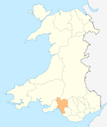
Towns and villages Aberavon · Aberdulais · Abergarwed · Alltwen · Baglan · Blaengwrach · Blaenhoddan · Cadoxton · Cilfrew · Cilybebyll · Clyne · Cwmgors · Cwmllynfell · Crynant · Glynneath · Godre'r Graig · Goytre · Groes · Llangiwg · Lonlas · Lower Brynamman · Margam · Melincourt Falls · Morfa Glas · Neath · Pontardawe · Port Talbot · Resolven · Rhiwfawr · Rhydyfro · Seven Sisters · Skewen · Tairgwaith · Tonna · YstalyferaCastles Rivers Categories:- Communities in Neath Port Talbot


Wikimedia Foundation. 2010.