- Maribyrnong, Victoria
-
Maribyrnong
Melbourne, Victoria
 Maribyrnong
Population: 8242 (2006)[1] Postcode: 3032 Area: 5.5 km² (2.1 sq mi) Location: 8 km (5 mi) from Melbourne LGA: City of Maribyrnong State District: Footscray Federal Division: Maribyrnong, Gellibrand Mean max temp Mean min temp Annual rainfall 19.7 °C
67 °F9.3 °C
49 °F553.3 mm
21.8 inSuburbs around Maribyrnong: Essendon West Aberfeldie Moonee Ponds Avondale Heights Maribyrnong Ascot Vale Maidstone Maidstone Footscray Maribyrnong is a suburb 8 km north-west of Melbourne, Victoria, Australia. Its Local Government Area is the City of Maribyrnong, part of River Ward.[2] At the 2006 Census, Maribyrnong had a population of 8242.
Maribyrnong takes its name from the Maribyrnong River which bounds the suburb to the north and east. Its other borders are Williamson Road, Rosamond Road, Mephan Street and Owen Street to the south.
Maribyrnong contains Highpoint Shopping Centre, one of Australia's largest shopping centres. The suburb is also home to the Anglers Tavern Hotel , located on the banks of the Maribyrnong River. The hotel is a popular night spot and eatery for locals and Melbournians alike.
Contents
History
A Maribyrnong Post Office opened on 19 March 1881 and closed in 1887. It reopened in 1912 and closed again in 1975.[3] There is currently an Australia Post at Highpoint Shopping Centre.
Maribyrnong is home to the Department of Defence ammunitions factory and storage facility. Although many of the buildings are now disused, the site has now been earmarked for development by the State Government for housing and low density commercial infrastructure.
 Highpoint Shopping Centre
Maribyrnong contains several schools, both Catholic and State Government run. Maribyrnong College (est 1958) is the sole high school in the suburb, which recently underwent significant renovations by the State Government. St Margarets Catholic Primary School and nearby Footscray North Primary School both cater for primary school aged children in the area.
There are also various kindergarten and child care centers dotted in and around Maribyrnong.
Flora and fauna
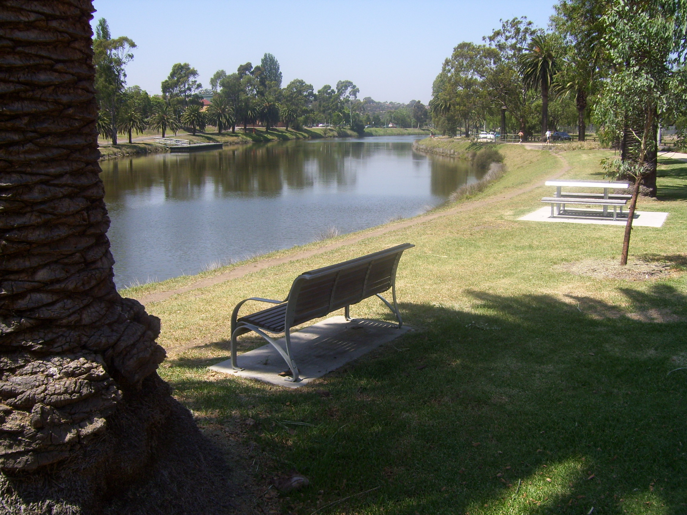
 The Maribyrnong river from the suburb of Maribyrnong
Many native species exist along the Maribyrnong River. Some species thrive in the area. The most noticeable are;
- Rainbow Lorikeet
- Common Brushtail Possum
- Flying Foxes or Fruit Bat Pteropus
- Cockatoo
Maribyrnong has numerous parks dotted mostly near the Maribyrnong River. These reservers are typically unsuitable for development due to the risk of flooding and thus have been established as gardens and reserves for locals to enjoy.
Places of worship
There is only one place of worship throughout the entire suburb of Maribyrnong - a church in the Roman Catholic tradition. St Margaret's which is the namesake of the Catholic primary school is part of the Parish of Ascot Vale, and shares the same priest which conducts services at St Mary's in Ascot Vale.[4]
Climate
Climate data for Maribyrnong Explosives Factory Month Jan Feb Mar Apr May Jun Jul Aug Sep Oct Nov Dec Year Average high °C (°F) 26.0
(78.8)25.3
(77.5)23.9
(75.0)19.7
(67.5)16.6
(61.9)13.8
(56.8)13.5
(56.3)14.7
(58.5)17.2
(63.0)19.4
(66.9)21.7
(71.1)24.4
(75.9)19.7 Average low °C (°F) 13.4
(56.1)13.6
(56.5)12.6
(54.7)9.9
(49.8)7.7
(45.9)5.9
(42.6)5.5
(41.9)5.8
(42.4)7.0
(44.6)8.6
(47.5)9.9
(49.8)12.1
(53.8)9.3 Precipitation mm (inches) 40.6
(1.598)40.8
(1.606)40.7
(1.602)46.3
(1.823)49.4
(1.945)39.0
(1.535)40.0
(1.575)45.8
(1.803)51.9
(2.043)57.7
(2.272)53.3
(2.098)48.2
(1.898)553.9
(21.807)Avg. precipitation days 5.0 5.4 7.1 9.0 11.7 11.2 12.1 12.0 11.3 11.5 9.8 7.8 113.9 Source: [5] Sport
Maribyrnong Aquatic Centre
The Maribyrnong Aquatic Centre was established in 2006.
Tracey's Speedway
Maribyrnong Reserve was previously utilized as a racetrack used for various motor sports events during the 1950s before closing in 1964.[6][7] Still situated at the ground are 2 free standing grand stands which have been refurbished at various times. In most cases the stands are rarely used for spectator events, and instead act as change rooms for local sports clubs which use the indoor facilities. Today the ground acts as a soccer pitch during winter months, and is also utilized by St Margaret's Primary School for some Australian Rules Football matches.
Transport
Trains
No trains run through the suburb. The nearest train stations are Ascot Vale on the Craigieburn line or Footscray and West Footscray stations on the Werribee, Sydenham and Williamstown lines.
Tram
The Route 57 tram provides public transport from Flinders Street Station (Elizabeth & Flinders Streets) in the city to West Maribyrnong running through Ascot Vale, Flemington and North Melbourne.
The Route 82 tram provides public transport from Moonee Ponds (Ascot Vale Road & Puckle Street) to Footscray (Leeds & Irving Streets). It is one of only three Melbourne tram routes which does not travel through the Melbourne CBD.
Buses
There are also several bus routes that run through Maribyrnong, many terminating at Highpoint Shopping Centre. Buses run to Caroline Springs, Avondale Heights, East Keilor and Essendon. The introduction of Melbourne's first orbital bus line, the SmartBus, runs just north of Maribyrnong along Buckley Street in Essendon.[8] Bus Lines running through Maribyrnong include the 215, 223, 406, 407, 408, 409, and 468.
Walking and cycling
The suburb adjoins the Maribyrnong River Trail which is used by commuting and recreational cyclists along the Maribyrnong River. There are also numerous bike and walking trails which link the suburb to various other suburbs and take in some of the western suburbs greatest natural beauties, such as Pipemakers Park, Afton Street Conservation Park and Footscray Park.
Recent developments
Despite being an inner city suburb, like many western suburbs, there are significant areas of land within Maribyrnong that have yet been developed. Mostly owned by the Federal Government for the Department of Defence, the land is now seen as a prime opportunity for housing developments. The most notable development recently under construction is the Delphin Lend Lease Edgewater, located near Highpoint on Gordon Street which takes in spectacular city views and is adjacent to the historic Jack's Magazine.
The largest development to be announced by the State Government is the 128 hectare Defence site of the Maribyrnong Explosives Factory, bound by the Maribyrnong river. 3,000 new homes are expected to be built, along with open parkland, shops and the inclusion of many decade old defence buildings in keeping with heritage. Construction is expected to commence is 2012 with the project taking 10 – 15 years to be fully completed.[9]
Notable residents
- Keith Ashton - local activist [10]
- Anthony Laughton - journalist
- Sandy - The only "Waler" (Australian military horse) to return from World War I[11]
- Dr Geoffrey Bichel- Local Artist and Colonel.
See also
- City of Footscray - the former local government area of which part of Maribyrnong was a part.
- City of Sunshine - the former local government area of which part of Maribyrnong was a part.
References
- ^ Australian Bureau of Statistics (25 October 2007). "Maribyrnong (State Suburb)". 2006 Census QuickStats. http://www.censusdata.abs.gov.au/ABSNavigation/prenav/LocationSearch?collection=Census&period=2006&areacode=SSC21431&producttype=QuickStats&breadcrumb=PL&action=401. Retrieved 2007-09-29.
- ^ Maribyrnong City Council - http://www.maribyrnong.vic.gov.au/Page/page.asp?Page_Id=63&h=0
- ^ Premier Postal History. "Post Office List". https://www.premierpostal.com/cgi-bin/wsProd.sh/Viewpocdwrapper.p?SortBy=VIC&country=. Retrieved 2008-04-11
- ^ Catholic Archdiocese of Melbourne - http://www.melbourne.catholic.org.au/parishes/parishdetail.asp?parish_id=337
- ^ "Climate statistics for Maribyrnong Explosives Factory". Bureau of Meteorology. http://reg.bom.gov.au/climate/averages/tables/cw_087038_All.shtml. Retrieved 9 August 2011.
- ^ 18/Jun/2009 Motorsport Archive.com
- ^ 18/Jun/2009 National Library of Australia
- ^ Metlink - http://www.metlinkmelbourne.com.au/assets/Maps/Localities/PDFs/28_Maribyrnong.pdf
- ^ VicUrban - http://www.vicurban.com/cs/Satellite?c=VPage&cid=1236308498393&pagename=VicUrban%2FLayout&site=VicUrban
- ^ The Age - http://www.theage.com.au/news/national/in-memory-of-a-big-brave-old-anzac/2005/10/22/1129775997132.html
- ^ http://www.awm.gov.au/encyclopedia/horses/sandy.asp
External links
Coordinates: 37°46′12″S 144°53′35″E / 37.77°S 144.893°E
Suburbs of the City of Maribyrnong | Melbourne | Victoria Braybrook · Footscray · Kingsville · Maidstone · Maribyrnong · Seddon · Tottenham · West Footscray · Yarraville
Categories:- Suburbs of Melbourne

Wikimedia Foundation. 2010.