- North Atlantic oscillation
-
For the rock band, see North Atlantic Oscillation (band).


The North Atlantic oscillation (NAO) is a climatic phenomenon in the North Atlantic Ocean of fluctuations in the difference of atmospheric pressure at sea level between the Icelandic low and the Azores high. Through east-west oscillation motions of the Icelandic low and the Azores high, it controls the strength and direction of westerly winds and storm tracks across the North Atlantic. It is part of the Arctic oscillation, and varies over time with no particular periodicity.[citation needed]
The NAO was discovered in the 1920s by Sir Gilbert Walker. Unlike the El Niño-Southern Oscillation phenomenon in the Pacific Ocean, the NAO is a largely atmospheric mode. It is one of the most important manifestations of climate fluctuations in the North Atlantic and surrounding humid climates.[citation needed]
The North Atlantic Oscillation is closely related to the Arctic oscillation (AO) or Northern Annular Mode (NAM), but should not be confused with the Atlantic Multidecadal Oscillation (AMO).
Contents
Definition
The NAO has multiple possible definitions. The easiest to understand are those based on measuring the seasonal average air pressure difference between stations, such as:
- Lisbon, Portugal and Stykkisholmur/Reykjavik, Iceland
- Ponta Delgada, Azores and Stykkisholmur/Reykjavik, Iceland
- Azores (1865–2002), Gibraltar (1821–2007), and Reykjavik, Iceland[1]
These definitions all have in common the same northern point (because this is the only station in the region with a long record) in Iceland; and various southern points. All are attempting to capture the same pattern of variation, by choosing stations in the "eye" of the two stable pressure areas: The Azores high and the Icelandic low (shown in the graphic).
A more complex definition, only possible with more complete modern records generated by numerical weather prediction, is based on the principal empirical orthogonal function (EOF) of surface pressure.[1] This definition has a high degree of correlation with the station-based definition. This then leads onto a debate as to whether the NAO is distinct from the AO/NAM, and if not, which of the two is to be considered the most physically based expression of atmospheric structure (as opposed to the one that most clearly falls out of mathematical expression).
Description
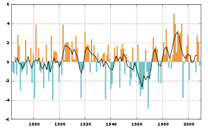 Winter index of the NAO based on the difference of normalized sea level pressure (SLP) between Lisbon, Portugal and Stykkisholmur/Reykjavik, Iceland since 1864, with a five year moving average (black)
Westerly winds blowing across the Atlantic bring moist air into Europe. In years when westerlies are strong, summers are cool, winters are mild and rain is frequent. If westerlies are suppressed, the temperature is more extreme in summer and winter leading to heatwaves, deep freezes and reduced rainfall.
A permanent low-pressure system over Iceland (the Icelandic Low) and a permanent high-pressure system over the Azores (the Azores High) control the direction and strength of westerly winds into Europe. The relative strengths and positions of these systems vary from year to year and this variation is known as the NAO. A large difference in the pressure at the two stations (a high index year, denoted NAO+) leads to increased westerlies and, consequently, cool summers and mild and wet winters in Central Europe and its Atlantic facade. In contrast, if the index is low (NAO-), westerlies are suppressed, these areas suffer cold winters and storms track southerly toward the Mediterranean Sea. This brings increased storm activity and rainfall to southern Europe and North Africa.
Especially during the months of November to April, the NAO is responsible for much of the variability of weather in the North Atlantic region, affecting wind speed and wind direction changes, changes in temperature and moisture distribution and the intensity, number and track of storms.
Although having a less direct influence than for Western Europe, the NAO is also believed to have an impact on the weather over much of eastern North America. During the winter, when the index is high (NAO+), the Icelandic low draws a stronger south-westerly circulation over the eastern half of the North American continent which prevents Arctic air from plunging southward. In combination with the El Niño, this effect can produce significantly warmer winters over the northeastern United States and southeastern Canada. Conversely, when the NAO index is low (NAO-), these areas can incur winter temperatures significantly colder than the norm.
North Atlantic hurricanes
See also: Pre-1600 Atlantic hurricane seasonsBy controlling the position of the Azores high, the NAO also influences the direction of general storm paths for major North Atlantic tropical cyclones: a position of the Azores high farther to the south tends to force storms into the Gulf of Mexico, whereas a northern position allows them to track up the North American Atlantic Coast.[2]
As paleotempestological research has shown, few major hurricanes struck the Gulf coast during 3000–1400 BC and again during the most recent millennium. These quiescent intervals were separated by a hyperactive period during 1400 BC and 1000 AD, when the Gulf coast was struck frequently by catastrophic hurricanes and their landfall probabilities increased by 3–5 times.[3][4][5]
Ecological effects
The NAO has been in an overall more positive regime since the late 1970s, bringing colder conditions to the North-West Atlantic, which has been linked with the thriving populations of Labrador Sea snow crabs, which have a low temperature optimum.[6]
The NAO+ warming of the North Sea reduces survival of cod larvae which are at the upper limits of their temperature tolerance, as does the cooling in the Labrador Sea, where the cod larvae are at their lower temperature limits.[6] Though not the critical factor, the NAO+ peak in the early 1990s may have contributed to the collapse of the Newfoundland cod fishery.[6]
On the East Coast of the United States an NAO+ causes warmer temperatures and increased rainfall, and thus warmer, less saline surface water. This prevents nutrient-rich upwelling which has reduced productivity. Georges Bank and the Gulf of Maine are affected by this reduced cod catch.[6]
The strength of the NAO is also a determinant in the population fluctuations of the intensively studied Soay sheep.[7]
Winter of 2009-10 in Europe
The winter of 2009-10 in Europe was unusually cold, especially during December, January and February. It is theorized that this may be due to solar activity.[8] The Met Office reported that the UK, for example, had experienced its coldest winter for 30 years. This coincided with an exceptionally negative phase of the NAO.[9] Analysis published in mid-2010 suggests it was caused by a freak combination of an 'El Nino' event and the rare occurrence of an extremely negative NAO.[10][11]
However, during the winter of 2010-11 in Northern and Western Europe, the Icelandic low, typically positioned west of Iceland and east of Greenland, appeared regularly to the east of Iceland and so allowed exceptionally cold air into Europe from the Arctic. A strong area of high pressure was initially situated over Greenland, reversing the normal wind pattern in the northwestern Atlantic, creating a blocking pattern driving warm air into northeastern Canada and cold air into Western Europe, as was the case during the previous winter. This occurred during a La Niña season, and is connected to the rare Arctic dipole anomaly.[12][13]
See also
- Arctic oscillation
- Antarctic oscillation
- Atlantic Ocean
- Anticyclone
- El Niño / Southern Oscillation Index
- Global warming
- Latitude of the Gulf Stream and the Gulf Stream north wall index
- Pacific decadal oscillation
- Pacific-North American teleconnection pattern
- North Atlantic Current
- North Atlantic Gyre
References
- ^ a b Hurrell, Jim. "NAO/NAM Climate Indices". CGD's Climate Analysis Section (National Center for Atmospheric Research). http://www.cgd.ucar.edu/cas/jhurrell/indices.html.
- ^ Scott, D. B.; Collins, E. S.; Gayes, P. T. & Wright, E. (2003). "Records of prehistoric hurricanes on the South Carolina coast based on micropaleontological and sedimentological evidence, with comparison to other Atlantic Coast records". Geological Society of America Bulletin 115 (9): 1027–1039. doi:10.1130/B25011.1.
- ^ Liu, Kam-biu; Fearn, Miriam L. (2000). "Reconstruction of Prehistoric Landfall Frequencies of Catastrophic Hurricanes in Northwestern Florida from Lake Sediment Records". Quaternary Research 54 (2): 238–245. Bibcode 2000QuRes..54..238L. doi:10.1006/qres.2000.2166.
- ^ McCloskey, T. A.; Knowles, J. T. (2009). "Migration of the tropical cyclone zone throughout the Holocene". In Elsner, J. B.; Jagger, T. H.. Hurricanes and Climate Change. New York: Springer. ISBN 9780387094090.
- ^ Elsner, James B.; Liu, Kam-biu; Kocher, Bethany (2000). "Spatial Variations in Major U.S. Hurricane Activity: Statistics and a Physical Mechanism". Journal of Climate 13 (13): 2293–2305. Bibcode 2000JCli...13.2293E. doi:10.1175/1520-0442(2000)013<2293:SVIMUS>2.0.CO;2.
- ^ a b c d Pearson, Aria (2009-01-03). "Perfect Storm: Why storms are good news for fishermen". New Scientist. pp. 32–35. http://www.newscientist.com/article/mg20126881.700-why-storms-are-good-news-for-fisherman--.html. Retrieved 2009-01-13.
- ^ Coulson, T; et al. (2001). "Age, Sex, Density, Winter Weather, and Population Crashes in Soay Sheep". Science 292 (5521): 1528–1531. Bibcode 2001Sci...292.1528C. doi:10.1126/science.292.5521.1528. PMID 11375487. http://www.sciencemag.org/cgi/content/abstract/292/5521/1528. Retrieved 2009-01-13.
- ^ http://www.sciencedaily.com/releases/2010/04/100415080848.htm
- ^ UK's climatic research unit NAO index data
- ^ Pamela Rutherford (2 Sep 2010). "Huge snowfall caused by rare clash of weather events". BBC News Online. http://www.bbc.co.uk/news/science-environment-11152077. Retrieved Dec 2010.
- ^ R. Seager, Y. Kushnir, J. Nakamura, M. Ting, and N. Naik (July 2010). "Northern hemisphere winter snow anomalies: ENSO, NAO and the winter of 2009/10". Lamont-Doherty Earth Observatory, Columbia University. doi:10.1029/2010GL043830. http://www.ldeo.columbia.edu/res/div/ocp/drought/snow.shtml. Retrieved Dec 2010.
- ^ Pearce, Fred (26 December 2010). "Why is it so cold? Simple... it's the North Atlantic Oscillation - and it's got a bit stuck". Daily Mail Online. http://www.dailymail.co.uk/sciencetech/article-1341618/Why-cold-Simple--North-Atlantic-Oscillation--got-bit-stuck.html. Retrieved 28 December 2010.
- ^ Masters, Jeffrey. "Florida shivers; Hot Arctic-Cold Continents pattern is back". Weather Underground. Jeff Masters' WunderBlog. http://www.wunderground.com/blog/JeffMasters/comment.html?entrynum=1710. Retrieved 28 December 2010.
External links
- Current NAO observations and forecasts
- UK's climatic research unit information sheet on the NAO
- Overview paper on the NAO from the USA's National Center for Atmospheric Research Hurrell at al, ~2002, 35pp
- The North Atlantic Oscillation by Martin Visbeck
- Overview of Climate Indices
- Heavy January snowfall caused by freak 'weather collision'
Climate oscillations Climate oscillations 8.2 kiloyear event · Antarctic Circumpolar Wave · Antarctic oscillation · Arctic dipole anomaly · Arctic oscillation · Atlantic Equatorial mode · Atlantic multidecadal oscillation · Bond event · Dansgaard–Oeschger event · Diurnal cycle · El Niño-Southern Oscillation · Equatorial Indian Ocean oscillation · Glacial cycles · Indian Ocean Dipole · Madden–Julian oscillation · Milankovitch cycles · North Atlantic oscillation · North Pacific Oscillation · Orbital forcing · Pacific decadal oscillation · Pacific-North American teleconnection pattern · Quasi-biennial oscillation · Seasons · Solar variability

Wikimedia Foundation. 2010.