- Kandy District
-
Kandy District
මහනුවර දිස්ත්රික්කය
கண்டி மாவட்டம்— Administrative District — Map of Sri Lanka with Kandy District highlighted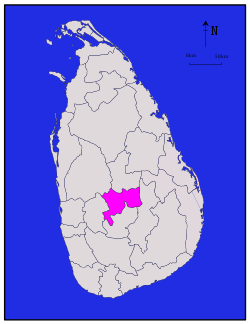
Coordinates: 7°15′N 80°45′E / 7.25°N 80.75°ECoordinates: 7°15′N 80°45′E / 7.25°N 80.75°E Country  Sri Lanka
Province Central Province Created Capital Kandy Divisions List- Divisional Secretariats: 20
- Grama Niladhari: 1,188
Government – District Secretary Gotabaya Jayarathna – Local List- Municipal Councils: 1
- Urban Councils: 3
- Pradeishiya Sabhas: 17
Area – Total 1,940 km2 (749 sq mi) – Land 1,917 km2 (740.2 sq mi) – Water 23 km2 (8.9 sq mi) Population (2001) – Total 1,279,028 – Density 659.3/km2 (1,707.6/sq mi) Time zone Sri Lanka (UTC+05:30) ISO 3166 code LK-21 Website ds.gov.lk/dist_kandy Kandy District (Sinhala: මහනුවර දිස්ත්රික්කය, Tamil: கண்டி மாவட்டம்) is a district of the Central Province of Sri Lanka. Its area is 1906.3 km²[1]. The capital of the district is Kandy.
Demographics
Ethnic groups Sinhalese 947,900 (74.11%) Sri Lankan Tamil 52,052 (4.07%) Sri Lankan Moor 168,049 (13.14%) Indian Tamil 103,622 (8.1%) Burgher 2,128 (0.17%) Sri Lankan Malay 2,668 (0.21%) Other 2,609 (0.2%) Religions Buddhism 937,001 (73.26%) Hinduism 134,438 (10.51%) Islam 173,590 (13.57%) Roman Catholic 23,232 (1.82%) Other Christian 10,330 (0.81%) Other 437 (0.03%) The population according to the 2001 census is 1,279,028 of which 74.1 % are Sinhalese, 13.1 % Sri Lankan Moors, 8.1 % Tamils of Indian origin and 4.1 % Sri Lankan Tamils.[2]
73.3 % of the population are Buddhists, 13.6 % Muslim, 10.5 % Hindu and 2.6 % Christian.[3]
References
Districts of Sri Lanka Central (Kandy • Matale • Nuwara Eliya) · Eastern (Ampara • Batticaloa • Trincomalee) · North Central (Anuradhapura • Polonnaruwa) · Northern (Jaffna • Kilinochchi • Mannar • Mullaitivu • Vavuniya) · North Western (Kurunegala • Puttalam) · Sabaragamuwa (Kegalle • Ratnapura) · Southern (Galle • Hambantota • Matara) · Uva (Badulla • Moneragala) · Western (Colombo • Gampaha • Kalutara)

This Kandy District, Central Province, Sri Lanka location article is a stub. You can help Wikipedia by expanding it.
