- Mullaitivu District
-
This article is about the district in Sri Lanka. For the town, see Mullaitivu.
Mullaitivu District
முல்லைத்தீவு மாவட்டம்
මුලතිවු දිස්ත්රික්කය— Administrative District — Location within Sri Lanka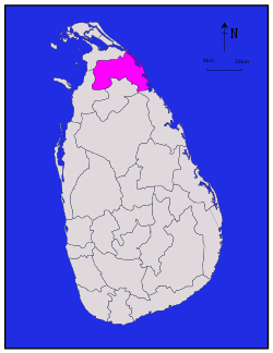
Coordinates: 09°14′N 80°32′E / 9.233°N 80.533°ECoordinates: 09°14′N 80°32′E / 9.233°N 80.533°E Country  Sri Lanka
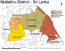
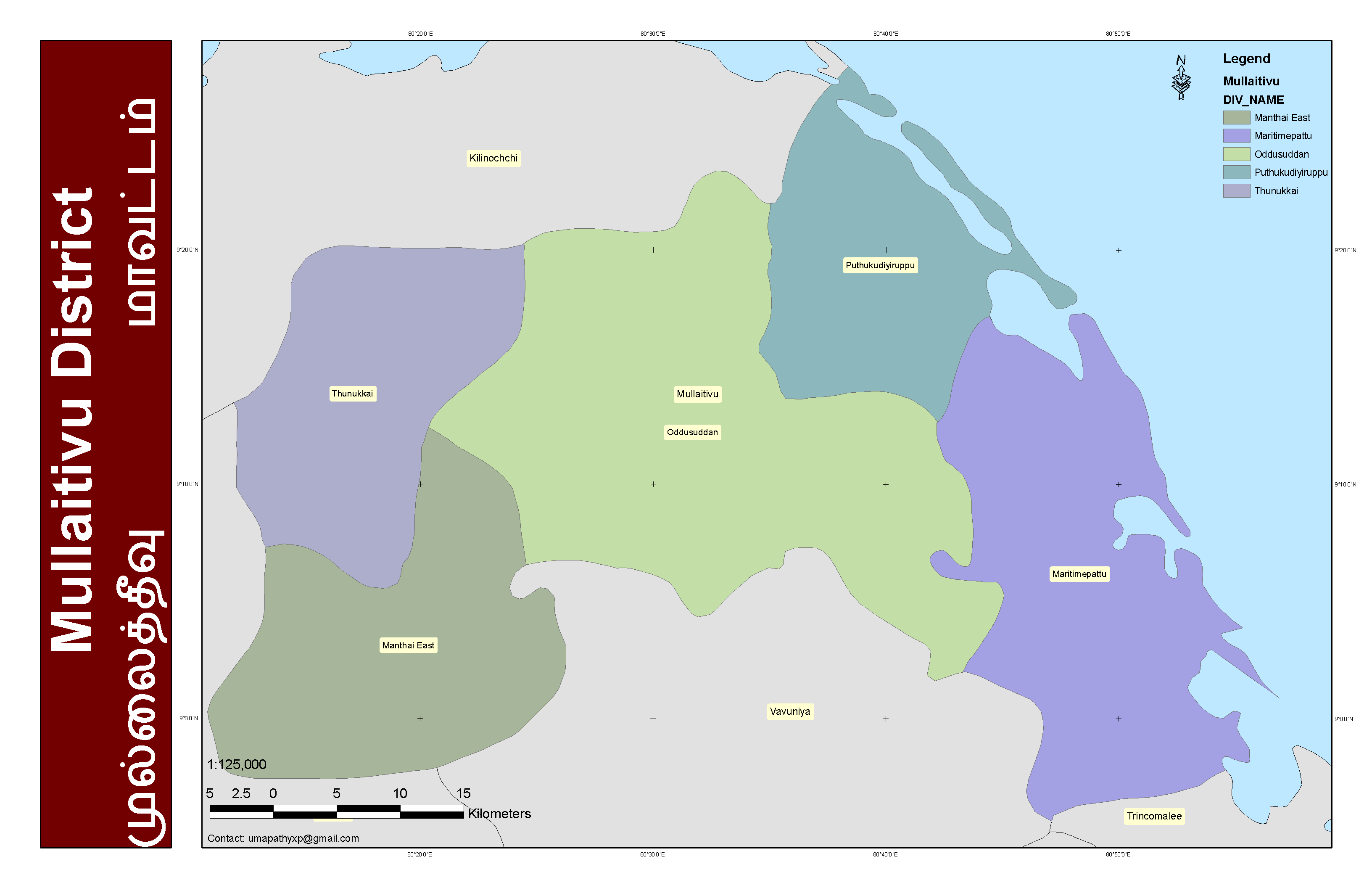
Province Northern Created September 1978 Capital Mullaitivu Divisional Secretariats List- Manthai East
- Maritimepattu
- Oddusuddan
- Puthukudiyiruppu
- Thunukkai
Government – District Secretary A. Pathinathar Area – Total 2,617 km2 (1,010.4 sq mi) – Land 2,415 km2 (932.4 sq mi) – Water 202 km2 (78 sq mi) 7.72% Area rank 11th (3.99% of total area) Population (2007) – Total 220,311 – Density 84.2/km2 (218/sq mi) Ethnicity(2007)[1] – Sri Lankan Tamil 220,117 (99.91%) – Moor 193 (0.09%) – Sinhalese 1 (0.00%) – Indian Tamil 0 (0.01%) – Other 0 (0.00%) Religion – Hindu – Catholic – Muslim – Buddhist – Other Time zone Sri Lanka (UTC+05:30) Post Codes 42000-42999 ISO 3166 code LK-45 Vehicle registration NP Official Languages Tamil, Sinhala Website Mullaitivu District Secretariat Mullaitivu district (Tamil: முல்லைத்தீவு மாவட்டம் Mullaittīvu, Sinhala: මූලදූව දිස්ත්රික්කය Mulativ) is one of the 25 administrative districts of Sri Lanka. The district is administered by a District Secretariat headed by a District Secretary (previously known as a Government Agent) appointed by the central government of Sri Lanka. The headquarters is located in Mullaitivu town. The district was carved out of the northern part of Vavuniya district together with parts of the then Jaffna district (now Kilinochchi district), Mannar district and Trincomalee district in September 1978.
Contents
History
The Mullativu area was colonized in the second half of the 18th century by Jaffna Tamils primarily from Alaveddy, Udduppidy and Navaly.[2].
Geography
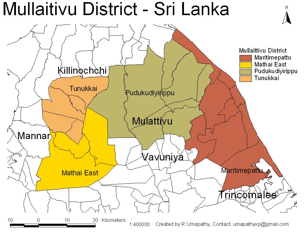
 Map of Mullatitivu District
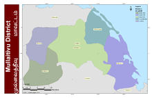
 Detailed map of Mullaitivu District
Mullaitivu district is located in the north east of Sri Lanka in the Northern Province. It has an area of 2,617 square kilometres (1,010 sq mi)[3].
Administrative units
Mullaitivu district is divided into 5 Divisional Secretary's (DS) Divisions, each headed by a Divisional Secretary (previously known as an Assistant Government Agent)[4]. The DS Divisions are further sub-divided into 127 Grama Niladhari (GN) Divisions (villages)[4].
DS Division Main Town GN
Divisions[4]Area
(km2)[5]Population[1] Manthai East Pandiyankulam 15 515.0 24,122 Maritimepattu Mullaitivu 46 744.6 55,809 Oddusuddan Oddusuddan 27 639.0 25,765 Puthukkudiyiruppu Puthukkudiyiruppu 19 371.0 89,784 Thunukkai Thunukkai 20 347.3 24,831 Total 127 2,616.9 220,311 Demographics
Population
Mullaitivu district's population was 220,311 in 2007[1]. The population of the district is almost exclusively Sri Lankan Tamil.
The population of the district, like the rest of the North and East, has been heavily affected by the civil war. The war has killed an estimated 70,000 people[6]. Several hundred thousand Sri Lankan Tamils, possibly as much as 400,000[7], have emigrated to the West since the start of the war. There are a further 800,000 internally displaced persons in Sri Lanka, many of them living in refugee camps in the North and East and depending on aid provided by NGOs[8]. There are approximately 100,000 Sri Lankan refugees is India[9]. Many Sri Lankan Tamils have also moved to the relative safety of Colombo. The war has also caused almost all of the Sri Lankan Moors and Sinhalese who lived in the district to flee to other parts of Sri Lanka.
Ethnicity
Population of Mullaitivu District by ethnic group 1981 to 2007 Year Sri Lankan Tamil Sri Lankan Moors Sinhalese Others Total No. % No. % No. % No. % No. % 1981 Census 69,670 89.88% 3,777 4.87% 3,948 5.09% 117 0.15% 77,512 100.00% 2001 Estimate1 79,544 99.99% 0 0.00% 8 0.01% 0 0.00% 79,552 100.00% 2007 Estimate 220,117 99.91% 193 0.09% 1 0.00% 0 0.00% 220,311 100.00% Source:[1] 1 2001 Census was not carried out in Mullaitivu district.
Politics and government
Local government
Mullaitivu district has four local authorities all of which are Pradeshya Sabhas[10].
Local Authority Elected
MembersArea
(km2)Population Manthai East Pradeshya Sabha 0 494.0 24,298 Maritimepattu Pradeshya Sabha 0 728.6 55,809 Puthukkudiyiruppu Pradeshya Sabha 9 968.0 115,605 Thunukkai Pradeshya Sabha 0 326.3 24,965 Source:[10] References
- ^ a b c d 2007 Estimate - Northern Provincial Council
- ^ Sivaratnam, C. (1968). The Tamils in early Ceylon. pp. 153. http://books.google.com/books?id=hlocAAAAMAAJ&q=%22This+Vanni+district+was+peacefully+colonised+in+the%22&dq=%22This+Vanni+district+was+peacefully+colonised+in+the%22&hl=en&ei=7ifVS6X9E5KCsgP279H6CQ&sa=X&oi=book_result&ct=result&resnum=1&ved=0CDgQ6AEwAA.
- ^ Department of Census & Statistics Statistical Abstract 2007
- ^ a b c Mullaitivu District Secretariat Administration Structure (GN Divisions)
- ^ Northern Provincial Council Statistical Handbook 2008 (Geographical)
- ^ BBC News Quick guide: Sri Lanka
- ^ Sri Lankan Tamil Migration
- ^ UNHCR Global Appeal 2008-2009 - Sri Lanka
- ^ Acharya, Arunkumar (2007). "Ethnic conflict and refugees in Sri Lanka". Autonomous University of Nuevo Leon
- ^ a b Northern Provincial Council Statistical Handbook 2008 (Administration and Local Government)
External links
Mullaitivu District Secretariat
Districts of Sri Lanka Central (Kandy • Matale • Nuwara Eliya) · Eastern (Ampara • Batticaloa • Trincomalee) · North Central (Anuradhapura • Polonnaruwa) · Northern (Jaffna • Kilinochchi • Mannar • Mullaitivu • Vavuniya) · North Western (Kurunegala • Puttalam) · Sabaragamuwa (Kegalle • Ratnapura) · Southern (Galle • Hambantota • Matara) · Uva (Badulla • Moneragala) · Western (Colombo • Gampaha • Kalutara)

Wikimedia Foundation. 2010.