- Pennsylvania Route 120
-
"U.S. Route 120" redirects here. For the US 120 in the preliminary 1925 plan, see U.S. Route 120 (1925).
PA Route 120

Highways in Pennsylvania with PA 120 in red.Route information Maintained by PennDOT Length: 106 mi[citation needed] (171 km) Existed: 1926 (as US 120) – present Major junctions West end: 
 US 219/PA 948 in Ridgway
 PA 255 in St. Marys
 PA 46 in Emporium
 PA 155 near Emporium
 PA 555 in Driftwood
 PA 872 near Jericho
 PA 144 in Renovo
East end:  US 220 in Lock Haven
Highway system Roads in Pennsylvania
Interstate • US • State • Legislative←  US 119
PA 121  →
→Pennsylvania Route 120 is a state highway in the U.S. state of Pennsylvania, running from U.S. Route 219 in Ridgway east to U.S. Route 220 in Lock Haven.
Contents
Bucktail State Park Natural Area
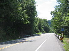 PA 120 in Clinton County, at the western end of Bucktail State Park Natural Area
In much of Cameron and Clinton counties, PA 120 is a scenic drive designated Bucktail State Park Natural Area. Bucktail State Park Natural Area runs 75 miles (121 km) from Emporium to Lock Haven, and is named for the Pennsylvania Bucktail Regiment, who came from the area during the American Civil War. PA 120 and the park run along Sinnemahoning Creek and the West Branch Susquehanna River and also pass through Renovo (in Clinton County).
Bucktail State Park Natural Area was established by the Pennsylvania State Legislature in 1933. It includes 21,039 acres (85.14 km2), of which 9,239 acres (37.39 km2) are in Cameron County and 11,800 acres (47.75 km2) in Clinton County. While much of the land is state owned and part of the Elk and Sproul State Forests, there are also many tracts of privately owned land within the official boundaries of the park. The law establishing the park defined its boundaries as "all that area of land extending in length from the western city line of Lock Haven, in Clinton County, to the eastern borough line of Emporium, in The County of Cameron, and along the course of the western branch of the Susquehanna River, and its tributary, Sinnemahoning Creek, in Clinton and Cameron counties, an estimated distance of 75 miles, and in width from mountain rim to mountain rim across the valley."[1] The park is primarily dedicated to wildlife viewing, especially elk.
History
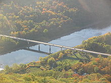 The PA 120 bridge over the West Branch Susquehanna River, as seen from Hyner View State Park in Clinton County.
Pennsylvania Route 120 follows an old Native American Trail, the Sinnemahoning Path. This trail was used by Native Americans to cross the eastern continental divide (specifically the Allegheny Front) between the Susquehanna River (which drains into the Chesapeake Bay) and the Allegheny River (which forms the Ohio River with the Monongahela River at Pittsburgh and eventually drains into the Gulf of Mexico via the Mississippi River). American Pioneers also used the trail to make their way west and it was also known as the Bucktail Trail
PA 120 was U.S. Route 120 until ca. 1967. US 120 was initially planned in 1926 as an Erie-Philadelphia route, but was truncated to Ridgway-Reading in 1927. The road east of Lock Haven became U.S. Route 220, U.S. Route 15 and U.S. Route 122 ca. 1935; this alignment is now roughly followed by US 220, Interstate 180, PA Route 147 and PA Route 61.
Major intersections
County Location Mile Destinations Notes Clinton Castanea Township 0.0 US 220Eastern terminus PA 120, Interchange Lock Haven 0.7  PA 150
Intersection with eastbound PA 150 only 0.7 PA 150Intersection with westbound PA 150 only 0.8  PA 664
Southern terminus of PA 664 Renovo 28.4 PA 144Eastern end of concurrency with PA 144 29.9 PA 144Western end of concurrency with PA 144 Cameron Grove Township 52.5 PA 872Southern terminus of PA 872 Driftwood 56.3 PA 555Eastern terminus of PA 555 Emporium 73.3 PA 155Southern terminus of PA 155 Emporium 74.7 PA 46Southern terminus of PA 46 Elk St. Marys 93.4 PA 255Northern end of concurrency with PA 255 93.6 PA 255Southern end of concurrency with PA 255 Ridgway 102.6 
US 219 TRKEastern end of concurrency with US 219 TRK 103.8
US 219 TRK/US 219Western end of concurrency with US 219 TRK, western terminus of US 219 TRK, western termius of PA 120 1.000 mi = 1.609 km; 1.000 km = 0.621 mi References
External links
Categories:- U.S. Route 20
- State highways in Pennsylvania


Wikimedia Foundation. 2010.