- Pennsylvania Route 664
-
PA Route 664
Route information Maintained by Pennsylvania Department of Transportation Length: 17.65 mi[1] (28.40 km) Existed: 1930 – present Major junctions South end:  PA 120 in Lock Haven
North end:  PA 44 in Haneyville
Location Counties: Clinton, Lycoming Highway system Roads in Pennsylvania
Interstate • US • State • Legislative←  PA 663
PA 666  →
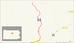
→Pennsylvania Route 664 (designated by the Pennsylvania Department of Transportation as SR 0664) is a 17.65-mile (28.40 km) long state highway located in Clinton and Lycoming counties in Pennsylvania. The southern terminus is at State Route 120 in Lock Haven, while the northern terminus is at State Route 44 on the Clinton-Lycoming county line in the community of Haneyville. The route passes through small communities, but does not intersect with any other legislated highways in the area.
The route was assigned in 1930, two years after a majority of state routes were assigned, and had continuous repavings done from 1935 to 1966. There have been no changes in road alignment since its inception.
Contents
Route description
 Pennsylvania Route 664 begins at Route 120 right here
State Route 664 begins at an intersection with State Route 120 in community of Lock Haven. The highway progresses northward, leaving the community limits of Lock Haven. After the intersection with East Water Street, State Route 664 crosses the West Branch of the Susquehanna River. The bridge over the branch of river was constructed in 1986.[2] At the intersection with Farrandsville Road, the highway turns eastward, paralleling the river. Nearing State Route 150, the highway turns northward and into Dunnstown. While winding around a few curves, State Route 664 intersects with Armory Drive, an access road to a local armory. The route's surroundings are highly developed in Dunnstown, with the highway passes along homes. At the intersection with Aikey Street, State Route 664 leaves Dunnstown and proceeds northward.[1]
The highway passes some homes and forests north of Dunnstown, entering Woodward Township soon after. At the intersection with Township Road 406, State Route 664 starts winding in several directions, but following a northward basis. This continues until the intersection with Arbutus Drive, where it heads straight to the northwest. At a clearing in a nearby forest, State Route 664 enters the community of Swissdale. The stay in the community is short, with the highway leaving after a few blocks. Just north of Swissdale, State Route 664 makes a long hairpin turn, curving from east to west before turning north once again. Just after the intersection with Honey Suckle Lane, State Route 664 progresses towards Haneyville.[1]
The next stretch of State Route 664 is full of bends, and the highway continuously turns at a constant rate. At an intersection with another Honey Suckle Lane, the highway starts its northwestern progression once again. This changes again when Tedrow Lane begins paralleling the highway. Now following a steady northeastern alignment, the highway continues through the large patches of trees south of Haneyville. At Little Plum Run Road, the highway turns onto a steady northward alignment. The highway continues through the trees for a while, continuing northward on its way to Gallagher Township.[1]
At a bend in the highway, there is a small patch of development, with a few houses near the highway. At the intersection with Township Road 529, State Route 664 enters Gallagher Township. Eventually, the large patch of forests in the surroundings come towards a clearing, where the highway intersects with Old Dirt Road. After crossing a stream, State Route 664 gains the moniker of the Coudersport Pike. The highway passes a small patch of development, reaching another clearing in the forest. After entering another forest, State Route 664 ends at an intersection with State Route 44 in the community of Haneyville.[1]
History
State Route 664 was assigned two years after the mass numbering of state routes in Pennsylvania in 1928.[3][4] The highway itself took several years to transition from gravel to actual pavement. The first segment, which occurred in 1935, was from Little Plum Run Road and northward.[5] The second segment was in 1936, when the Pennsylvania Department of Highways paved the piece of State Route 664 from a point just south of Gallagher to the Gallagher Township line.[6] In 1938, the third segment, from Swissdale to Gallagher Township was paved.[7]
In 1949, the Department of Highways paved the piece of State Route 664 from Gallagher Township to the Lycoming County line.[8] In 1951, the section between Swissdale and Little Plum Run Road was paved once again.[9] Two years after that, the section from the Lycoming County line to State Route 44 was improved in its condition.[10] That lone section was improved in 1966.[11] There have been no recorded changes in alignment since its 1930 assignment.[12]
Major intersections
County Location Mile[1] Destinations Notes Clinton Lock Haven 0.00 PA 120 (Renovo Road)Southern terminus Lycoming Haneyville 17.65 PA 44Northern terminus 1.000 mi = 1.609 km; 1.000 km = 0.621 mi References
- ^ a b c d e f Yahoo! Inc. Yahoo! Maps – overview map of State Route 664 (Map). Cartography by NAVTEQ. http://maps.yahoo.com/#mvt=h&lat=41.32711&lon=-77.471786&zoom=18&q1=41.136942%2C-77.442486&q2=41.325555%2C-77.47493. Retrieved 2008-12-24.
- ^ National Bridge Inventory: Structure Number: 180664001000880. United States Department of Transportation. 2007.
- ^ Pennsylvania Department of Highways (1928). Map Showing Pennsylvania State Highways (Map).
- ^ Pennsylvania Department of Highways (1930). Tourist Map of Pennsylvania State Highways (Map).
- ^ Pennsylvania Department of Highways (1935). Tourist Map of Pennsylvania State Highways (Map).
- ^ Pennsylvania Scenic and Historical Commission (1936). Carefree Holidays Await You in Pennsylvania (Map).
- ^ Pennsylvania Commission (1938). Pennsylvania (Map).
- ^ Pennsylvania Department of Highways (1949). Official Road Map - Pennsylvania (Map).
- ^ Pennsylvania Department of Highways (1951). Official Map - Pennsylvania Highways (Map).
- ^ Pennsylvania Department of Highways (1953). Official Road Map - Pennsylvania (Map).
- ^ Pennsylvania Department of Highways (1966). Discover the New Pennsylvania - Official Highway Map (Map).
- ^ Pennsylvania Department of Transportation (2008). Pennsylvania (Map).
External links
Categories:- State highways in Pennsylvania
- Transportation in Clinton County, Pennsylvania
- Transportation in Lycoming County, Pennsylvania


Wikimedia Foundation. 2010.