- South Kazakhstan Province
-
South Kazakhstan Province
Оңтүстік Қазақстан облысы
Южно-Казахстанская область— Province — 
Coat of armsMap of Kazakhstan, location of South Kazakhstan Province highlighted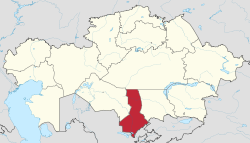
Coordinates: 43°00′N 068°30′E / 43°N 68.5°ECoordinates: 43°00′N 068°30′E / 43°N 68.5°E Country  Kazakhstan
Capital Shymkent Government – Akim Myrzakhmetov Askar Isabekovich Area[1] – Total 117,300 km2 (45,289.8 sq mi) Population (2007-01-01)[1] – Total 2,282,500 – Density 19.5/km2 (50.4/sq mi) Time zone East (UTC+6) – Summer (DST) not observed (UTC+6) Postal codes 160000 Area codes +7 (725) ISO 3166 code KZ-ZHA Vehicle registration X Districts 11 Cities 8 Townships 13 Villages 932 Website www.ontustik.gov.kz South Kazakhstan Province (Kazakh: Оңтүстік Қазақстан облысы, Oñtüstik Qazaqstan oblısı) is the southernmost province of Kazakhstan, with a population of 2,282,500 people. Its capital is Shymkent, with 539,600 people. Other cities in South Kazakhstan include Turkestan, Sayram, Kentau, Arys, Shardara, Jetysu, Saryag'ash and Lenger. This province and Atyrau Province are Kazakhstan's two smallest provinces; both are about 117,300 square kilometers in area. South Kazakhstan borders the neighboring country of Uzbekistan (and is very near the Uzbekistan capital Tashkent), as well as three other Kazakhstan provinces: Karagandy Province (to the north), Kyzylorda Province (to the west) and Jambyl Province (to the east). The Syr Darya passes through the province, on its way to the Aral Sea. Also, an oil pipeline runs from Turkmenabat, Turkmenistan to Omsk, Russia (where it connects with a larger, Siberian pipeline) through South Kazakhstan. Oil, lead and zinc are refined in Shymkent.
Contents
Demographics
The South Kazakhstan Province is the most densely populated of Kazakhstan's many regions. This derives from the oblast's gentler climate, better irrigation infrastructure, and proximity to historical population centers [such as Uzbekistan's Tashkent and the Silk Road cities of Samarkand and Bukhara]. SKO is also the fastest growing of Kazakhstan's Province, due to two main factors. One is the birthrate among traditional Kazakh and Uzbek families, where families of five to eight children are commonplace. The other is the exodus of cheap migrant labor from northern Uzbekistan. These migrant workers sometimes become full-fledged immigrants, and if they are ethnic Kazakhs this process is easily green-lighted through local governments for an (unacknowledged and under-the-table) fee.
As such, South Kazakhstan Province is the only province with a demographic breakdown where ethnic Russians are not in the first or second most populous categories. Census results are old and made using Soviet methods that served propaganda over accuracy, but they still point to Kazakhs being the most populous, closely followed by Uzbeks, with Russians bringing in a distant third.
The population of Southern Kazakhstan, despite obvious numerical prevalence of Kazakhs (which has considerably amplified from the beginning 1990 and now the share of Kazakhs in the population makes an order of 72 %), differs a considerable ethnolanguage variety. So in the area population it is traditionally wide (about 18 % of all population) the Uzbeks making a considerable part of the population of some cities and areas of area are presented (to Sauries, Turkestan, Aksukent, Ikan), live Russian (basically in the city of Shymkent though their share was considerably reduced for last 20 years from more than 23 % in 1980 to nearby 6 % now), Tadjiks, Koreans, Kurds live also. Are extended Kazakh, Russian (including as means of international dialogue) and Uzbek languages.
History
Historically speaking, South Kazakhstan Province is home to Kazakhstan's oldest and greatest marvels. Two thousand years ago it was part of the northern border of the Persian Empire. It owes its long history of habitation to a mixing of Persian culture and science with the native Turkic/Mongol tribal clans. South Kazakhstan Province was part of the Satrap of Sogdiana.
Some places of historical interest include the cities of Turkestan, Otrar and Sayram. Sayram was the birthplace of Ahmed Yasavi (1103–66), a great Sufic scholar and author that lived and worked throughout Central Asia. He is entombed in a mausoleum complex that stands in present-day Turkestan, and which has been named a World Heritage Site by UNESCO. It was commissioned by Amir Temur (Tamerlane) to increase his standing among the area. The mausoleum was built by Persian masters, though it was left unfinished with the death of Tamerlane. The original scaffolding that would have been used to apply the colored-tile still protrudes from the front entrance.
References
- National Geographic Atlas of the World, Eighth Edition.
External links
 Media related to South Kazakhstan Province at Wikimedia Commons
Kyzylorda Province Karagandy Province Zhambyl Province Navoiy Province,  Uzbekistan
 South Kazakhstan Province

Jizzax Province, UzbekistanSirdaryo Province, UzbekistanTashkent Province, Uzbekistan South Kazakhstan ProvinceCapital: Shymkent
Districts 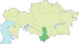
Major cities  Provinces of Kazakhstan
Provinces Akmola · Aktobe · Almaty · Atyrau · East Kazakhstan · Karagandy · Kostanay · Kyzylorda · Jambyl · Mangystau · North Kazakhstan · Pavlodar · South Kazakhstan · West Kazakhstan
Metropolitan cities Categories:


Wikimedia Foundation. 2010.