Atyrau Province

Atyrau Province

Infobox Province of Kazakhstan
Kazakh_name = Атырау облысы
lat_deg = 47 | lat_min = 07 | lat_sec = 0
lon_deg = 51 | lon_min = 53 | lon_sec = 0
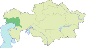


ISOAbbrev = ATY
capital = Atyrau
largest_city =
governor = Bergey Ryskaliev
raions = 7
cities = 2
towns = 10
villages = 188
area = 118600
area_source =
population = 479984
pop_date = 2006-12-01
pop_ref = [ [http://www.e-atyrau.kz/rus/index.php?name=Pages&op=page&pid=1 Official site - General Information] ]
utc_offset = +5
PLZ = 060000
area_code = +7 (712)
licence_plate = E
Website = http://www.e-atyrau.kz/eng/

Atyrau Province ( _kz. Атырау облысы) is a province of Kazakhstan. It is situated in the west of the country around the northeast of the Caspian Sea. Its capital is the city of Atyrau, with a population of 142,500 people; the province itself has 380,000 people. With an area of 118,600 square kilometers, it is the second-smallest province in Kazakhstan (South Kazakhstan Province is the smallest). It borders the neighboring country Russia, as well as fellow Kazakh provinces Aktobe Province, Mangystau Province, and West Kazakhstan Province. A large part of the province is situated in the oil-rich Caspian Depression; because of this, many oil wells have been drilled in the Tengiz Field area, and a pipeline runs from Atyrau (the city) to Grozny, Russia, where it intersects with a Russian pipeline going to Europe.

External links

* [http://www.e-atyrau.kz/eng/ Official website]

References

* "National Geographic Atlas of the World", Eighth Edition.


Wikimedia Foundation. 2010.

Игры ⚽ Нужна курсовая?

Look at other dictionaries:

  • Atyrau — Infobox Settlement official name = Atyrau native name = Атырау |The Central Mosque Imangali (in honour to Imangali Tasmagambetov) image map caption = pushpin pushpin label position =bottom pushpin mapsize = 280 pushpin map caption =Location in… …   Wikipedia

  • Mangystau Province — Маңғыстау облысы Мангистауская область   Province   Map of Kazakhstan, location of Mangystau Provi …   Wikipedia

  • South Kazakhstan Province — Оңтүстік Қазақстан облысы Южно Казахстанская область   Province   …   Wikipedia

  • Aktobe Province — Infobox Province of Kazakhstan Kazakh name = Ақтөбе облысы lat deg = 50 | lat min = 17 | lat sec = 0 lon deg = 57 | lon min = 10 | lon sec = 0 ISOAbbrev = AKT capital = Aktobe largest city = governor = Eleusin Sagyndykov raions = 12 cities = 8… …   Wikipedia

  • North Kazakhstan Province — Солтүстік Қазақстан облысы Северо Казахстанская область   Province   …   Wikipedia

  • Mukur, Kazakhstan — For other settlements, see Mukur. Mukur   Village   Coordinates …   Wikipedia

  • Makat District — Makat   District   Мақат ауданы Country …   Wikipedia

  • Makhambet District — Makhambet   District   Махамбет ауданы Country …   Wikipedia

  • Salimzhan Nakpaev — Salimzhan Zhumashuly Nakpaev (Kazakh: Сәлімжан Жұмашұлы Нақпаев [sælɪmˈʒɑn ʒʊmɑʃʊˈlɯ nɑqˈpɑjəf], Russian: Салимжан Жумашевич Накпаев [salʲimˈʒan ʒuˈmaʃɪvʲitʃ nakˈpajɪf]), born in 1966, has since October 2006 served as the mayor of Atyrau, the… …   Wikipedia

  • Provinces of Kazakhstan — Kazakhstan is divided into 14 provinces (Kazakh: облыстар / oblystar; singular: облысы / oblysy; Russian: области / oblasti; singular: область / oblast ). The provinces are further subdivided into districts (Kazakh: аудандар / audandar; singular …   Wikipedia

Share the article and excerpts

Direct link
Do a right-click on the link above
and select “Copy Link”