- North Kazakhstan Province
-
North Kazakhstan Province
Солтүстік Қазақстан облысы
Северо-Казахстанская область— Province — 
Coat of armsMap of Kazakhstan, location of North Kazakhstan Province highlighted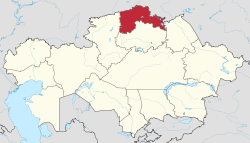
Coordinates: 54°53′N 69°10′E / 54.883°N 69.167°ECoordinates: 54°53′N 69°10′E / 54.883°N 69.167°E Country  Kazakhstan
Capital Petropavl Government - Akim Serik Bilyalov Area[1] - Total 98,040 km2 (37,853.5 sq mi) Population (2005-01-01)[1] - Total 665,800 - Density 6.8/km2 (17.6/sq mi) Time zone East (UTC+6) - Summer (DST) not observed (UTC+6) Postal codes 150000 Area codes +7 (715) ISO 3166 code KZ-SEV Vehicle registration T Districts 13 Cities 5 Townships Villages 208 Website http://www.sko.kz North Kazakhstan Province (Kazakh: Солтүстік Қазақстан облысы, Soltüstik Qazaqstan oblısı) is a province of Kazakhstan, with a population of 665,800. Its capital is Petropavl, with a population of 193,300 people. The province borders Russia to the north, and also borders three other Kazakh provinces: Akmola Province to the south, Pavlodar Province to the east and Kostanay Province to the west. The area of the province is 98,040 square kilometers, making it the fourth smallest of all the Kazakh provinces. The Ishim (Esil) River, a tributary of the Irtysh River, flows from Karagandy Province to Russia through North Kazakhstan Province.
Contents
Travel information
There are interesting landscapes, forest tracts and lake areas of Shalkar and Imantau nature zones. There are many places of historical and cultural value, very important for archeology, history, architecture and monument art. In the aul of Syrymber the country estate of Shokan Valikhanov, the first Kazak scientist was reconstructed, a fine memorial of the wood architecture of the 19th century. You can see memorial monument, which was stated in honour of national heroes Karasay and Agyntay near Saumalkol. There are plenty of archeological objects (burial mounds, ancient cities of ancient settlements) in the regions of the Ishim, the Chaglinka, the Iman Burluk rivers. In the natural boundary Botay (Iman-Burluk river) more than 60000 objects were discovered, which let to suppose that the domestication of wild horse by the ancient Man started here about 5,5 thousands years ago. The information presented you by the KAZAKHSTAN-REISEN national tour operator for Kazakhstan. You can obtain information about travel services and visa support absolutely free. All additional information about hotels, seasonal temperatures and actual situation is also available absolutely free. Just follow the external links at the bottom of this page.
Demographics
The major ethnic groups are as follows:
- Russians (48.5% in 2006, 49.79% in 1999 & 51.49% in 1989).
- Kazakhs (32.3% in 2006, 29.57% in 1999 & 22.59% in 1989).
- Ukrainian (6.3% in 2006, 6.47% in 1999 & 7.73% in 1989).
- German (3.9% in 2006, 5.67% in 1999 & 9.51% in 1989).
- Polish (2.7% in 2006, 2.58% in 1999 & 2.51% in 1989).
- Tatar (2.2% in 2006, 1.54% in 1999 & 1.80% in 1989).
- Byelorussian (1.2% in 2006, 2.46% in 1999 & 2.89% in 1989).
- Others, mostly Greeks, Mordvin & Uzbek (2.9% in 2006, 2.11% in 1999 & 2.18% in 1989).[2]
The population — about 725 thousand inhabitants.
National structure of the North Kazakhstan region [2]
People 1989, % 1999, % 2009 [3], %
Russian 48,21 49,79 48,25
Kazakhs 22,59 29,57 35,89
Ukrainians 7,73 6,47 4,55
Germans 9,51 5,67 2,7
Poles 2,51 2,58 2,7
Tatars 1,80 1,54 2,3
Byelorussians 2,89 2,46 1,2
Others 2,18 2,11 2,11
In total 100,00 100,00 100,00
The national structure also considerably varies on areas and area cities. So, in Petropavlovsk Russian make — 71,12 % of the population, in Ualihanovsky area Kazakhs — 86,04 % of the population prevail. In more details about national structure of areas according to 2004 under the reference [1]. The Polish diaspora largest in Kazakhstan (Poles in Kazakhstan See) lives In area.
Besides, СКО was unique area in Kazakhstan with natural decline in population, however since 2008 in area the natural increase of the population [4] is observed.
External links
References

 Russia
Kostanay Province 
Pavlodar Province  North Kazakhstan Province

Akmola Province  North Kazakhstan Province
Capital: Petropavl Districts Aiyrtau · Akkayin · Akzhar · Esil · Gabit Musirepov · Kyzylzhar · Magzhan Zhumabaev · Mamlyut · Shal akyn · Taiynsha · Timiryazev · Ualikhanov · Zhambyl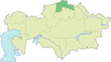
Major cities  Provinces of Kazakhstan
Provinces Akmola · Aktobe · Almaty · Atyrau · East Kazakhstan · Karagandy · Kostanay · Kyzylorda · Jambyl · Mangystau · North Kazakhstan · Pavlodar · South Kazakhstan · West Kazakhstan
Metropolitan cities Categories:- North Kazakhstan Province
- Provinces of Kazakhstan
- Kazakhstan geography stubs


Wikimedia Foundation. 2010.