Kyzylorda Province

Kyzylorda Province

Infobox Province of Kazakhstan
Kazakh_name = Қызылорда облысы
state_coa = Kyzylorda_province_seal.pngcoa_size =
coa_link =
lat_deg = 45 | lat_min = 0 | lat_sec = 0
lon_deg = 64 | lon_min = 0 | lon_sec = 0
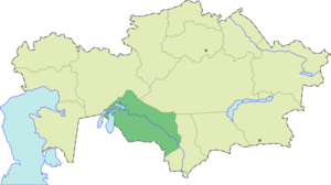


ISOAbbrev = KZY
capital = Kyzylorda
largest_city =
governor = Mukhtar Kul-Mukhammed
raions = 7
cities = 2
towns = 6
villages =
area = 226000
area_source =
population = 596000
pop_date = 2006-09-01
pop_ref =
utc_offset = +6
PLZ = 120000
area_code = +7 (724)
licence_plate = N
Website = http://www.kyzylorda.kz/

Kyzylorda (( _kz. Қызылорда облысы) is a province of Kazakhstan. Its capital is the city of Kyzylorda, with a population of 157,400. The province itself has a population of 590,000. Other notable settlements include Aralsk, Qazaly (Kazalinsk) and the Russian-administered Baikonur, which services the Baikonur Cosmodrome. The province borders neighboring country Uzbekistan, as well as three other provinces: Aktobe Province, Karagandy Province, and South Kazakhstan Province. The Syr Darya River, flowing from the Tian Shan mountains to the Aral Sea, passes through Kyzylorda Province. The total area of the province is 226,000 square kilometers.

ee also

*Barsa-Kelmes Nature Reserve

External links

* [http://www.kyzylorda.kz/ Official regional administration website]

References


Wikimedia Foundation. 2010.

Игры ⚽ Поможем решить контрольную работу

Look at other dictionaries:

  • Kyzylorda — Infobox City official name = Kyzylorda native name = Қызылорда |Train station image map caption = pushpin pushpin label position =bottom pushpin mapsize = 280 pushpin map caption =Location in Kazakhstan subdivision type = Country subdivision… …   Wikipedia

  • Kyzylorda — Héraldique …   Wikipédia en Français

  • South Kazakhstan Province — Оңтүстік Қазақстан облысы Южно Казахстанская область   Province   …   Wikipedia

  • Navoiy Province — Coordinates: 42°0′N 64°15′E / 42°N 64.25°E / 42; 64.25 …   Wikipedia

  • Karagandy Province — Infobox Province of Kazakhstan Kazakh name = Қарағанды облысы state coa = Coat of Arms of Karagandy Province.svg coa size = coa link = lat deg = 48 | lat min = 0 | lat sec = 0 lon deg = 71 | lon min = 0 | lon sec = 0 ISOAbbrev = KAR capital =… …   Wikipedia

  • Aktobe Province — Infobox Province of Kazakhstan Kazakh name = Ақтөбе облысы lat deg = 50 | lat min = 17 | lat sec = 0 lon deg = 57 | lon min = 10 | lon sec = 0 ISOAbbrev = AKT capital = Aktobe largest city = governor = Eleusin Sagyndykov raions = 12 cities = 8… …   Wikipedia

  • North Kazakhstan Province — Солтүстік Қазақстан облысы Северо Казахстанская область   Province   …   Wikipedia

  • Mangystau Province — Маңғыстау облысы Мангистауская область   Province   Map of Kazakhstan, location of Mangystau Provi …   Wikipedia

  • Provinces of Kazakhstan — Kazakhstan is divided into 14 provinces (Kazakh: облыстар / oblystar; singular: облысы / oblysy; Russian: области / oblasti; singular: область / oblast ). The provinces are further subdivided into districts (Kazakh: аудандар / audandar; singular …   Wikipedia

  • Outline of Kazakhstan — …   Wikipedia

Share the article and excerpts

Direct link
Do a right-click on the link above
and select “Copy Link”