- Tierra del Fuego Province, Chile
-
Tierra del Fuego Province
Provincia de Tierra del Fuego— Province — Location in the Magallanes Region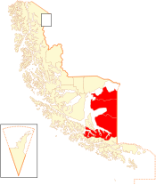 Location in Chile
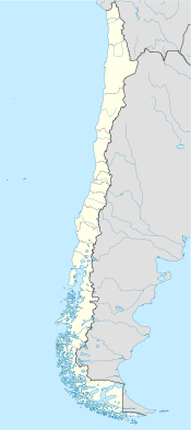
 Tierra del Fuego Province
Coordinates: 53°36′S 69°23′W / 53.6°S 69.383°WCoordinates: 53°36′S 69°23′W / 53.6°S 69.383°W Country Chile Region Magallanes Capital Porvenir Communes Porvenir
Primavera
TimaukelGovernment - Type Provincial - Governor Catalina Besnier Anguita Area[1] - Total 22,592.7 km2 (8,723.1 sq mi) Population (2002 Census)[1] - Total 6,904 - Density 0.3/km2 (0.8/sq mi) - Urban 4,734 - Rural 2,170 Sex[1] - Men 4,418 - Women 2,486 Time zone CLT [2] (UTC-4) - Summer (DST) CLST [3] (UTC-3) Area code(s) 56 + 61 Website Government of Tierra del Fuego Tierra del Fuego Province (Spanish: Provincia de Tierra del Fuego) is one of four provinces in the southern Chilean region of Magallanes and Antártica Chilena (XII). It includes the Chilean part of the main island of Tierra del Fuego. There is also an Argentine province of the same name, Tierra del Fuego Province, Argentina. Chilean Tierra del Fuego has two major cities, Porvenir, capital of the province, and Cerro Sombrero, and a number of smaller towns. A key geographical feature is Bahía Inútil ("Useless Bay"), so named by British geographers in the late 19th century because the bay is not useful as a port.[citation needed]
Contents
Geology and hydrography
Gold-bearing sands have been recorded at a number of sites within the Fuegan shores of the Tierra del Fuego Province.[4] Chilean Tierra del Fuego is known for numerous small lakes including Lago Blanco and Lago Deseado.
Demography
According to the 2002 census by the National Statistics Institute (INE), the province spans an area of 22,592.7 km2 (8,723 sq mi)[1] and had a population of 6,904 inhabitants (4,418 men and 2,486 women), giving it a population density of 0.3 /km2 (1 /sq mi). It is the third most sparsely populated province in the country after Antártica Chilena and Capitan Prat, and it is the fifth least populated province in the country. Of these, 4,734 (68.6%) lived in urban areas and 2,170 (31.4%) in rural areas. Between the 1992 and 2002 censuses, the population fell by 1.2% (81 persons).[1]
History
The shores among the islands have provided settlement locations for early man in the Americas; in particular the Wulaia Bay area of Navarino Island has yielded evidence of early settlement by the Yaghan people.[5]
See also
References
- C. Michael Hogan (2008) Bahia Wulaia Dome Middens, Megalithic Portal, ed. Andy Burnham
- J. Rabassa (2008) The Late Cenozoic of Patagonia and Tierra Del Fuego, Published by Elsevier, 524 pages ISBN 0444529543
- ^ a b c d e (Spanish) "Territorial division of Chile" (PDF). National Statistics Institute. 2007. http://www.ine.cl/canales/chile_estadistico/territorio/division_politico_administrativa/pdf/dpa_completa.pdf. Retrieved 18 March 2011.
- ^ "Chile Time". WorldTimeZones.org. http://www.world-time-zones.org/zones/chile-time.htm. Retrieved 2010-07-28.
- ^ "Chile Summer Time". WorldTimeZones.org. http://www.world-time-zones.org/zones/chile-summer-time.htm. Retrieved 2010-07-28.
- ^ J. Rabassa, 2008
- ^ C. Michael Hogan, 2008
Provinces of Chile Aisén • Antártica Chilena • Antofagasta • Arauco • Arica • Biobío • Cachapoal • Capitán Prat • Cardenal Caro • Cauquenes • Cautín • Chacabuco • Chañaral • Chiloé • Choapa • Coihaique • Colchagua • Concepción • Copiapó • Cordillera • Curicó • El Loa • Elqui • General Carrera • Huasco • Iquique • Isla de Pascua • Limarí • Linares • Llanquihue • Los Andes • Magallanes • Maipo • Malleco • Marga Marga • Melipilla • Ñuble • Osorno • Palena • Parinacota • Petorca • Quillota • Ranco • San Antonio • San Felipe de Aconcagua • Santiago • Talagante • Talca • Tamarugal • Tierra del Fuego • Tocopilla • Última Esperanza • Valdivia • Valparaíso< Communes and municipalities in Magallanes y Antártica Chilena Region Última Esperanza Province 
Magallanes Province Tierra del Fuego Province Antártica Chilena Province Categories:- Tierra del Fuego
- Provinces of Chile
- Divided regions
- Magellan and Chilean Antarctica Region


Wikimedia Foundation. 2010.