- Maipo Province
-
Maipo Province
Provincia de Maipo— Province — Location in the Santiago Metropolitan Region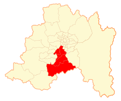 Location in Chile
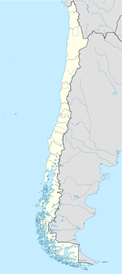
 Maipo Province
Coordinates: 33°45′S 70°46′W / 33.75°S 70.767°WCoordinates: 33°45′S 70°46′W / 33.75°S 70.767°W Country Chile Region Santiago Metropolitan Capital San Bernardo Communes List of 4:- Buin
- Paine
- San Bernardo
- Calera de Tango
Government - Type Provincial - Governor Area[1] - Total 1,120.5 km2 (432.6 sq mi) Area rank 5 Population (2002 Census)[1] - Total 378,444 - Rank 3 - Density 337.7/km2 (874.8/sq mi) - Urban 336,198 - Rural 42,246 Sex[1] - Men 187,789. - Women 190,655 Time zone CLT [2] (UTC-4) - Summer (DST) CLST [3] (UTC-3) Area code 56 + 2 Website Governorate of Maipo Maipo Province (Spanish: Provincia de Maipo) is one of six provinces in the Santiago Metropolitan Region of central Chile. Its capital is San Bernardo.
Contents
Administration
As a province, Maipo is a second-level administrative division of Chile, governed by a provincial governor who is appointed by the president.
Communes
The province is composed of four communes (Spanish: comunas), each governed by a municipality consisting of an alcalde and municipal council:
- Buin
- Paine
- San Bernardo, capital
- Calera de Tango
Geography and demography
The province spans an area of 1,120.5 km2 (433 sq mi), making it the second smallest province in the Santiago Metropolitan Region. According to the 2002 census, Maipo was the third most populous province in the region with a total population of 378,444. At that time, there were 336,198 people living in urban areas, 42,246 living in rural areas, 187,789 men, and 190,655 women.[1]
References
- ^ a b c d (Spanish) Instituto Nacional de Estadísticas
- ^ "Chile Time". WorldTimeZones.org. http://www.world-time-zones.org/zones/chile-time.htm. Retrieved 2010-07-28.
- ^ "Chile Summer Time". WorldTimeZones.org. http://www.world-time-zones.org/zones/chile-summer-time.htm. Retrieved 2010-07-28.
External links
Provinces of Chile Aisén • Antártica Chilena • Antofagasta • Arauco • Arica • Biobío • Cachapoal • Capitán Prat • Cardenal Caro • Cauquenes • Cautín • Chacabuco • Chañaral • Chiloé • Choapa • Coihaique • Colchagua • Concepción • Copiapó • Cordillera • Curicó • El Loa • Elqui • General Carrera • Huasco • Iquique • Isla de Pascua • Limarí • Linares • Llanquihue • Los Andes • Magallanes • Maipo • Malleco • Marga Marga • Melipilla • Ñuble • Osorno • Palena • Parinacota • Petorca • Quillota • Ranco • San Antonio • San Felipe de Aconcagua • Santiago • Talagante • Talca • Tamarugal • Tierra del Fuego • Tocopilla • Última Esperanza • Valdivia • Valparaíso< Communes and municipalities in Santiago Metropolitan Region > Santiago Province Santiago · Cerrillos · Cerro Navia · Conchalí · El Bosque · Estación Central · Huechuraba · Independencia · La Cisterna · La Florida · San Ramón · La Granja · La Pintana · La Reina · Las Condes · Lo Barnechea · Lo Espejo · Lo Prado · Macul · Maipú · Ñuñoa · Pedro Aguirre Cerda · Peñalolén · Providencia · Pudahuel · Quilicura · Quinta Normal · Recoleta · Renca · San Joaquín · San Miguel · Vitacura
Chacabuco Province Cordillera Province Maipo Province Melipilla Province Talagante Province Categories:- Provinces of Chile
- Santiago Metropolitan Region
- Chile geography stubs


Wikimedia Foundation. 2010.