- O'Higgins Region
-
O'Higgins Region
VI Región del Libertador
General Bernardo O'Higgins— Region of Chile — 

Flag
Coat of armsMap of O'Higgins Region
Country Chile Capital Rancagua Provinces Cachapoal, Colchagua, Cardenal Caro Government – Intendant Héctor Huenchullán Area[1] – Total 16,387 km2 (6,327.1 sq mi) Area rank 14 Lowest elevation 0 m (0 ft) Population (2002)[1] – Total 780,627 – Rank 6 – Density 47.6/km2 (123.4/sq mi) ISO 3166 code CL-LI The VI O'Higgins Region (Spanish: VI Región del Libertador General Bernardo O'Higgins) is one of Chile's 15 first order administrative divisions. It is subdivided into three provinces. It is named in honour of Bernardo O'Higgins Riquelme, one of Chile's founding fathers.
The O'Higgins Region is bordered to the west by the Pacific Ocean, to the east by the Republic of Argentina, to the north by the Valparaíso and Santiago Metropolitan Regions, and to the south by the Maule Region. It extends approximately between the parallels of 33°51’ and 35°01’ south latitude, and between the meridian of 70°02’ west longitude and the Pacific Ocean.
The capital and largest city of the region is Rancagua. The second major town is San Fernando.
Contents
Geography
In pre-Quaternary times extensive Nothofagus forests covered much of O'Higgins Region.[2]
The O'Higgins Region is part of the very restricted range of the endangered Chilean Wine Palm, Jubaea chilensis; in prehistoric times this Chilean endemic tree had a significantly larger range.[3]
History
From 9000 BCE to 300 BCE (the Archaic Period), the humans who inhabited the region moved between the coast and the valley as well as the Andes. At sites such as Pichilemu, Cáhuil and Bucalemu, they left trash deposits or shell middens bearing testimony to their raids[citation needed]. During the Agroalfarero Period (300 BCE - 1470 CE), the inhabitants experienced changes in their way of life, the most important being the cultivation of vegetables and the manufacture of clay objects. From 600 CE onwards, they started cultivating beans, maize, squashes, pumpkins and Quinoa[citation needed]. All of these except Quinoa and some types of maize required irrigation, which prompted them to move to the banks of creeks and rivers. During this period, groups of people lived in Quincha houses with straw roofs, in the vicinity of irrigation channels and horticulture crops, a style of life attributable to the Promaucaes or Picunches and to the Chiquillanes. During the Colonial Period (1541 CE to 1811 CE), the region became dominated, like the rest of the country, by the Spanish, and a system of ranching became predominant[citation needed].
Demography
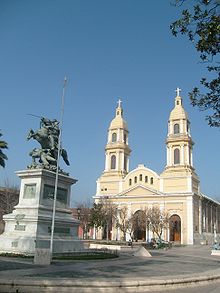 Cathedral at Plaza de los Heroes
 See also: List of cities in Chile#O'Higgins Region
The O'Higgins region contains a large part of the rural population (surpassed only by the Maule Region). Amongst the highly populated cities, Rancagua (206,971 inhabitants) stands out for having been transformed, in recent times, into an outskirt of Santiago. It is close being located 87 km south of Santiago. It is the capital of the Cachapoal Province as well the O'Higgins Region. According to the census of 2002,[4] other densely populated cities are: San Fernando (49,519 inhabitants); Rengo (30,891); Machalí (23,920); Graneros (21,616); San Vicente de Tagua Tagua (18,914); Santa Cruz (18,603); Chimbarongo (13,795); San Francisco de Mostazal (12,037); and Pichilemu (9,027) a well-known beach resort city founded by Agustin Ross Edwards in the late 19th century.
Economy
The main industrial and export activity takes place at CODELCO’s El Teniente mine, which contributes 7.7% of Chile’s copper production. The ore is processed at the Sewell and Colón concentrator plants, smelted and refined at Caletones, and shipped from the port of San Antonio, in the Valparaíso Region. Byproducts include molybdenum and silver.
Agriculture contributes 30.1% of the region’s GDP. One out of every four hectares of fruit orchards in Chile is in the O’Higgins Region. The main crops are apples and pears, followed by table grapes, plums, kiwis, and nectarines.
Manufacturing activity in the region is mostly related to copper mining, agribusiness, and food and beverages. One particular growth area is the production of fruit juices and pulp, and dehydrated fruit.
Over the past few years, there has been significant development in the forestry sector, especially plantations of eucalyptus and radiata pine.
Law and Government
The region is governed by an intendant, who is appointed by the president. Moises Saravia is the current intendant (2011).
The administration of the region rests with the regional government, which is headed by the intendant and the regional council (Consejo Regional de Chile). The latter comprises sixteen regional administrators, who are elected indirectly (ten from Cachapoal, four from Colchagua, and two from Cardenal Caro).
Administrative divisions
For purposes of interior administration, the O'Higgins region is divided into three provinces:
- Cachapoal Province, capital: Rancagua,
- Colchagua Province, capital: San Fernando,
- Cardenal Caro Province, capital: Pichilemu.
The provinces are subdivided into 33 communes.
See also: List of communes in ChilePolitico-administrative divisions of the O'Higgins Region Province Capital Commune Cachapoal Rancagua 1 Codegua 2 Coínco 3 Coltauco 4 Doñihue 5 Graneros 6 Las Cabras 7 Machalí 8 Malloa 9 Mostazal 10 Olivar 11 Peumo 12 Pichidegua 13 Quinta de Tilcoco 14 Rancagua 15 Rengo 16 Requínoa 17 San Vicente de Tagua Tagua Cardenal Caro Pichilemu 18 La Estrella 19 Litueche 20 Marchihue 21 Navidad 22 Paredones 23 Pichilemu Colchagua San Fernando 24 Chépica 25 Chimbarongo 26 Lolol 27 Nancagua 28 Palmilla 29 Peralillo 30 Placilla 31 Pumanque 32 San Fernando 33 Santa Cruz 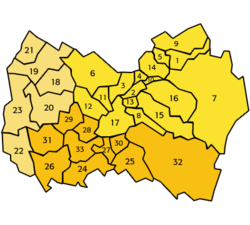
Culture
This area is known as the "huaso province" after the name of the Chilean cowboy, the huaso. Sashes and mantas – traditional items of the huaso costume – are woven in Doñihue on heavy vertical looms. Designs imitate vine leaves, bunches of grapes, pines and copihues. Other designs of colored stripes are woven on horizontal looms.
The population is a mixture of both European (including Argentinan immigrants) and Indigenous races and cultures, thus the region has a homogeneous culture known as Chileanidad is present and a mestizo imprint is evident.
The O'Higgins region had Spanish (most notably are Andalusian, Basque, Aragonese and Navarrese) settlers and other European immigrants in its history. The French and Italian families established agriculture with the key Chilean wine industry from their vineyards. Breweries can be found as well to produce beer is the legacy of German and Swiss immigration. Livestock herding was co-founded by some British, Greek and Yugoslavian settlers.
The Wine Route is one of the main tourist attractions of the Colchagua valley and has resulted in an important economic revival.
In the late 19th century, a small number of Cherokee and Oklahoman settlers of American Indian descent from Indian Territory, USA came to the O'Higgins region by the Chilean government. The Cherokee were displaced by white Anglo settlement in Oklahoma at the time, so they accept an offer to settle in Chile, then founded a cooperative farm (1880's) Ovasso an Osage language word for "the end" or "edge". The farm settlement was abandoned from lack of successful farm production.[citation needed][dubious ]
There is quite a small colony of Aartis or "Artas", East Indians descended from hired rail workers came from then British India in the early 20th century. The Artas are from a Hindi language word for "shining cloth" that was wore over their bodies during Hindu religious rites, but they rather call themselves desis.[citation needed][dubious ]
Due to a relatively close distance to Santiago, a more urban influence has been present in the local culture. The largest city, Rancagua is fast-becoming a suburb of Santiago's upper-class professional workforce.[citation needed]
Regional Festivals
Anniversaries Date English Name Spanish Name Notes 1–2 October Disaster of Rancagua Desastre de Rancagua In memory of the Battle
of Rancagua which occurred in 1814References
- ^ a b "O´Higgins Region". Government of Chile Foreign Investment Committee. http://www.cinver.cl/english/chile/ohiggins.asp. Retrieved 13 March 2010.
- ^ Thomas T. Veblen, Robert S. Hill and Jennifer Read (1996) The Ecology and Biogeography of Nothofagus Forests, Yale University Press, 403 pages ISBN 0-300-06423-3
- ^ C. Michael Hogan (2008) Chilean Wine Palm: Jubaea chilensis, GlobalTwitcher.com, ed. Nicklas Stromberg
- ^ "Chile: Proyecciones y Estimaciones de Población. Total País 1950-2050" Instituto National de Estadísticas (INE)
External links
- "The Libertador Bernardo O’Higgins Region" at the Chilean government website (Spanish)
- Regional government of the O'Higgins Region (Spanish)
- VI.cl: Portal de la Sexta Región (Portal for the Sixth Region) (Spanish)
- Pichilemu's official website (Spanish)
Regions of Chile XV Arica and Parinacota · I Tarapacá · II Antofagasta · III Atacama · IV Coquimbo · V Valparaíso · VI O'Higgins · VII Maule · VIII Biobío · IX Araucanía · XIV Los Ríos · X Los Lagos · XI Aisén · XII Magallanes · RM Santiago Metropolitan

< Communes and municipalities in O'Higgins Region > Cachapoal Province 
Cardenal Caro Province Colchagua Province Chépica · Chimbarongo · Lolol · Nancagua · Palmilla · Peralillo · Placilla · Pumanque · San Fernando · Santa CruzCoordinates: 34°10′02″S 70°43′37″W / 34.16722°S 70.72694°W
Categories:


Wikimedia Foundation. 2010.