- Malleco Province
-
Malleco Province
Provincia de Malleco— Province — Location in the Araucanía Region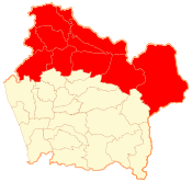 Location in Chile
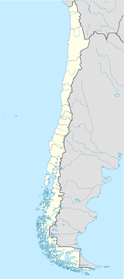
 Malleco Province
Coordinates: 38°15′S 72°15′W / 38.25°S 72.25°WCoordinates: 38°15′S 72°15′W / 38.25°S 72.25°W Country Chile Region Araucanía Capital Angol Communes List of 11:- Angol
- Renaico
- Collipulli
- Lonquimay
- Curacautín
- Ercilla
- Victoria
- Triaguen
- Lumaco
- Purén
- Los Sauces
Government - Type Provincial - Governor Area[1] - Total 13,433.3 km2 (5,186.6 sq mi) Population (2002 Census)[1] - Total 201,615 - Density 15/km2 (38.9/sq mi) - Urban 139,261 - Rural 43,801 Sex[1] - Men 100,227 - Women 101,388 Time zone CLT [2] (UTC-4) - Summer (DST) CLST [3] (UTC-3) Area code(s) 56 + 45 Website Government of Malleco Malleco Province (Spanish: Provincia de Malleco) is one of two provinces in the southern Chilean region of Araucanía (IX). Its estimated population is 223,184 (2005)[citation needed], and it covers an area of 13,433 km2 (5,187 sq mi). The provincial capital is the city of Angol.
Malleco Province is known for having the emblematic Malleco Viaduct and the Las Raíces Tunnel, Chile's longest tunnel that links the eastern part of Malleco province to the rest of the province.
Communes
As one of Chile's second level administrative divisions, Malleco comprises eleven communes, each administered by its respective municipality.
- Angol
- Renaico
- Collipulli
- Lonquimay
- Curacautín
- Ercilla
- Victoria
- Traiguén
- Lumaco
- Purén
- Los Sauces
Geography and demography
According to the 2002 census by the National Statistics Institute (INE), the province spans an area of 13,433.3 km2 (5,187 sq mi)[1] and had a population of 201,615 inhabitants (100,227 men and 101,388 women), giving it a population density of 15 /km2 (39 /sq mi). Of these, 139,261 (69.1%) lived in urban areas and 43,801 (21.7%) in rural areas. Between the 1992 and 2002 censuses, the population fell by 0.7% (1,422 persons).[1]
References
 This article incorporates text from a publication now in the public domain: Chisholm, Hugh, ed (1911). Encyclopædia Britannica (11th ed.). Cambridge University Press.
- ^ a b c d e (Spanish) "Territorial division of Chile" (PDF). National Statistics Institute. 2007. http://www.ine.cl/canales/chile_estadistico/territorio/division_politico_administrativa/pdf/dpa_completa.pdf. Retrieved 18 March 2011.
- ^ "Chile Time". WorldTimeZones.org. http://www.world-time-zones.org/zones/chile-time.htm. Retrieved 2010-07-28.
- ^ "Chile Summer Time". WorldTimeZones.org. http://www.world-time-zones.org/zones/chile-summer-time.htm. Retrieved 2010-07-28.
Provinces of Chile Aisén • Antártica Chilena • Antofagasta • Arauco • Arica • Biobío • Cachapoal • Capitán Prat • Cardenal Caro • Cauquenes • Cautín • Chacabuco • Chañaral • Chiloé • Choapa • Coihaique • Colchagua • Concepción • Copiapó • Cordillera • Curicó • El Loa • Elqui • General Carrera • Huasco • Iquique • Isla de Pascua • Limarí • Linares • Llanquihue • Los Andes • Magallanes • Maipo • Malleco • Marga Marga • Melipilla • Ñuble • Osorno • Palena • Parinacota • Petorca • Quillota • Ranco • San Antonio • San Felipe de Aconcagua • Santiago • Talagante • Talca • Tamarugal • Tierra del Fuego • Tocopilla • Última Esperanza • Valdivia • Valparaíso< Communes and municipalities in Araucanía Region > Cautín Province Carahue · Cholchol · Cunco · Curarrehue · Freire · Galvarino · Gorbea · Lautaro · Loncoche · Melipeuco · Nueva Imperial · Padre Las Casas · Perquenco · Pitrufquén · Pucón · Saavedra · Temuco · Teodoro Schmidt · Toltén · Vilcún · Villarrica
Malleco Province Angol · Collipulli · Curacautín · Ercilla · Lonquimay · Los Sauces · Lumaco · Purén · Traiguén · Renaico · VictoriaCategories:


Wikimedia Foundation. 2010.