- Curacautín
-
Curacautín
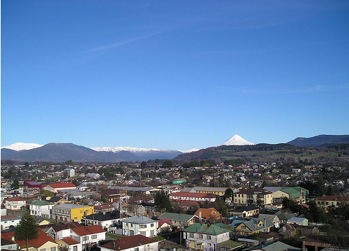
Fuerte Curacautín— City and Commune — View of Curacautín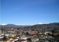
Coat of armsMap of the Curacautín commune in the Araucanía Region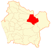 Location in Chile
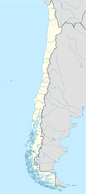
 Curacautín
Coordinates (city): 38°26′S 71°53′W / 38.433°S 71.883°WCoordinates: 38°26′S 71°53′W / 38.433°S 71.883°W Country Chile Region Araucanía Region Province Malleco Province Established March 12, 1882 Government[1][2] - Type Municipality - Alcalde Jorge Saquel Albarran (Ind.) Area[3] - Total 1,664.2 km2 (642.6 sq mi) Population (2002 Census)[3] - Total 16,970 - Density 10.2/km2 (26.4/sq mi) - Urban 12,412 - Rural 4,558 Demonym Curacautinense(s) Sex[3] - Men 8310 - Women 8660 Time zone CLT (UTC−4) - Summer (DST) CLST (UTC−3) Postal Code 4700000 Area code(s) 56 + 45 Website Municipality of Curacautín Curacautín, which means "Gathering Stone" in Mapudungun, is a commune and city in the Chilean province of Malleco. Curacautín is located 90 kilometres northeast of Temuco, in a valley near the volcanoes Tolhuaca, Lonquimay and Llaima, all of which can be seen from the city. Historically, it served as a highway of sorts for the Pehuenches that lived on either side of the Andes mountain range.
Contents
Volcanic Origin
This area is valued for its natural beauty. Conguillío and Tolhuaca National Parks; Malleco, Malalcahuello, and Nalcas National Reserves are all close by
History
The fort at Curacautín was founded on March 12, 1882 by Gregorio Urrutia Venegas.
Between 1913 and 1915, two important structures (the railroad and the Greater City Hall) were built. In 1938, Mosso plywood factory began production, being the fist in Chile to export plywood. This, coupled with the railroad, allowed products to be shipped all over Chile as well as internationally. This factory was one of the main employers of the commune, having a big impact in every aspect of the city. In 2000, FOCURA (formerly Mosso) its declares in bankruptcy, ending an era in Curacautín.[4]
Demographics
According to the 2002 census of the National Statistics Institute, Curacautín spans an area of 1,664 km2 (642 sq mi) and has 16,970 inhabitants (8,310 men and 8,660 women). Of these, 12,412 (73.1%) lived in urban areas and 4,558 (26.9%) in rural areas. Between the 1992 and 2002 censuses, the population fell by 6.4% (1,165 persons).[3]
Administration
As a commune, Curacautín is a third-level administrative division of Chile administered by a municipal council, headed by an alcalde who is directly elected every four years. The 2008-2012 alcalde is Jorge Saquel Albarran (Ind.).[1][2]
Within the electoral divisions of Chile, Curacautín is represented in the Chamber of Deputies by Enrique Estay (UDI) and Fuad Chahín (PDC) as part of the 49th electoral district, (together with Victoria, Lonquimay, Melipeuco, Vilcún, Lautaro, Perquenco and Galvarino). The commune is represented in the Senate by Alberto Espina Otero (RN) and Jaime Quintana Leal (PPD) as part of the 14th senatorial constituency (Araucanía-North).
References
- ^ a b (Spanish) "Asociación Chilena de Municipalidades". http://www.mcuracautin.cl/. Retrieved 7 February 2011.
- ^ a b (Spanish) "Municipality of Curacautín". http://www.mcuracautin.cl/. Retrieved 7 February 2011.
- ^ a b c d (Spanish) "National Statistics Institute". http://www.ine.cl/canales/chile_estadistico/censos_poblacion_vivienda/censo_pobl_vivi.php. Retrieved 8 September 2010.
- ^ http://historiadecuracautin.blogspot.com/2007/10/historia-fabrica-mosso.html
External links
- (Spanish) Municipality of Curacautín
< Communes and municipalities in Araucanía Region > Cautín Province Carahue · Cholchol · Cunco · Curarrehue · Freire · Galvarino · Gorbea · Lautaro · Loncoche · Melipeuco · Nueva Imperial · Padre Las Casas · Perquenco · Pitrufquén · Pucón · Saavedra · Temuco · Teodoro Schmidt · Toltén · Vilcún · Villarrica
Malleco Province Angol · Collipulli · Curacautín · Ercilla · Lonquimay · Los Sauces · Lumaco · Purén · Traiguén · Renaico · VictoriaCategories:- Communes of Chile
- Populated places established in 1882
- Populated places in Malleco Province


Wikimedia Foundation. 2010.