- Conguillío National Park
-
Conguillío National Park 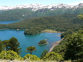
Lake ConguillíoLocation Araucanía Region, Chile Nearest city Melipeuco, Curacautin Coordinates 38°40′00″S 71°39′00″W / 38.6666667°S 71.65°WCoordinates: 38°40′00″S 71°39′00″W / 38.6666667°S 71.65°W Area 608 km² Established 1950 Visitors 21,805 (in 2004) Governing body Corporación Nacional Forestal Conguillío National Park is located in the Andes, in the provinces of Cautín and Malleco, in the Araucanía Region of Chile. Its name derives from the Mapuche word for "water with Araucaria seeds". This national park covers about 608 square kilometers.
Among the attractions in the park are the Llaima volcano, Sierra Nevada and wild landscapes characterized by islands of vegetation completely surrounded by vast areas of basaltic to andesitic lava flows.
Extensive forests, formed mainly by Araucarias and Nothofagus, and lagoons increase the scenic beauty of the park. It is also known as Los Paraguas (The Umbrellas), due to the shape of the Monkey Puzzle trees.
The park was used as filming location for Walking with Dinosaurs, a television series produced by the BBC.
Contents
Acces
- Sector Umbrellas is accessed by way Vilcún-Drawer-Cherquenco, asphalt from drawer to Cherquenco, rest gravel, all-weather, except snow days, so you must use chains and four-wheel drive .
- Sector Conguillío: by Victoria-Curacautín, Route CH-181 Curacautín paved road to the rest gravel, passable throughout the year to care Captrén, depending on snow accumulation, the rest passable only in summer period from November to March. You can also access this sector until the park entrance road Curacautín Lautaro to Curacautín, the remaining gravel in good condition, then continues roofing to control house, 8 km approximately.
- Sector Melipeuco: paved road to Melipeuco. The rest is gravel in fair condition and passable throughout the year to Truful-Truful booth.
Llaima volcano eruption
The January 1 of 2008 was the last eruption of the volcano. The park had to be evacuated, including about 150 tourists and employees of CONAF, because at 18:20 hours local time the volcano Llaima erupted. During the eruption, launched vent s and solid material to a thousand feet above the main crater, located to 3,150 meters, authorities said. [1]
See also
- Araucarias Biosphere Reserve
- Lake Conguillío
References
- (Spanish) Parque Nacional Conguillío
External links
National Parks of Chile Alberto de Agostini | Alerce Andino | Archipiélago de Juan Fernández | Bernardo O'Higgins | Bosque de Fray Jorge | Cabo de Hornos | Chiloé | Conguillío | Corcovado | Hornopirén | Huerquehue | Isla Guamblin | Isla Magdalena | La Campana | Laguna del Laja | Laguna San Rafael | Las Palmas de Cocalán | Lauca | Llanos de Challes | Llullaillaco | Nahuelbuta | Nevado Tres Cruces | Pali Aike | Pan de Azúcar | Puyehue | Queulat | Radal Siete Tazas | Rapa Nui | Tolhuaca | Torres del Paine | Vicente Pérez Rosales | Villarrica | Volcán Isluga

This article related to a protected area in South America is a stub. You can help Wikipedia by expanding it.
