- Llullaillaco National Park
Infobox_protected_area | name = Llullaillaco National Park
iucn_category = II
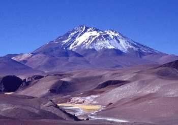
caption = Llullaillaco
locator_x =
locator_y =
location =Antofagasta Region ,Chile
nearest_city = Antofagasta
lat_degrees = 24
lat_minutes = 43
lat_seconds = 0
lat_direction = S
long_degrees = 68
long_minutes = 37
long_seconds = 0
long_direction = W
area = 2,687 km²
established =
visitation_num =
visitation_year =
governing_body =Corporación Nacional Forestal Llullaillaco National Park is a national park of
Chile , located 275 km southeast ofAntofagasta in theAndes . It lies between the eastern slopes of theCordillera Domeyko and the international border withArgentina . In the park there are several important mountains that culminate at the summit ofLlullaillaco volcano. The park also is characterized by extensive semi-desert plains interspersed by "Quebradas". A part of theInca road system is found in "Río Frío" area.The park's vegetation is dominated by high Andean steppes. In the park have been recorded 126 flora species, 21 of which are endemic to the area.cite journal | author = Marticorena, A. | coauthors = V. Pardo, A. Peñaloza, M.A. Negritto, L.A. Cavieres & M. Parada | title = Adiciones y notas a la flora del Parque Nacional Llullaillaco, II Región, Chile. | journal = Gayana Bot. | date = 2004 | volume = 61 | issue = 2 | pages = 49–54 | url = http://www.scielo.cl/scielo.php?script=sci_arttext&pid=S0717-66432004000200001&lng=es&nrm=iso
accessdate = 2007-09-30 | id =ISSN :0717-6643]Herds of
vicuña s wander through the park.References
*Es icon [http://www.sernatur.cl/Areas_Silvestres/Antofagasta/Antofagasta.html Parque Nacional Llullaillaco]
Wikimedia Foundation. 2010.