- South China Sea Islands
-
The South China Sea Islands consist of over 250 around 1-km² islands, atolls, cays, shoals, reefs, and sandbars in the South China Sea, most of which have no indigenous people, many of which are naturally under water at high tide, some of which are permanently submerged. The features are grouped into three archipelagos (listed by area size), Macclesfield Bank and Scarborough Shoal:
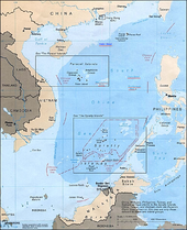 South China Sea
- The Spratly Islands, disputed between the People's Republic of China, the Republic of China, and Vietnam, with Malaysia, Brunei, and the Philippines claiming part of the archipelago[1]
- The Paracel Islands, disputed between the People's Republic of China, the Republic of China, and Vietnam[2]
- The Pratas Islands, disputed between the People's Republic of China and the Republic of China
- The Macclesfield Bank, disputed between the People's Republic of China, the Philippines, and the Republic of China
- The Scarborough Shoal, disputed between the People's Republic of China, the Philippines, and the Republic of China
There are minerals, natural gas, and oil deposits on the islands and under their nearby seafloor, also an abundance of sealife, such as fish, animals and vegetation traditionally exploited as food by all the claimant nations for thousands of years - mostly without disputes that could risk war. in the 20th Century, since the WW2 settlements failed to resolve ownership of such lesser areas of land, seas and islands, (even Formosa Island) - and because of the economic, military, and transportational importance - their control, especially that of the Spratlys, has been in dispute between China and several Southeast Asian countries such as Vietnam from the mid-20th century onwards. True occupation and control are shared between the claimants. (See Claims and control)
Contents
History
The countries with the most extensive activity in the South China Sea Islands are China and Vietnam.
In the 19th century, as a part of the occupation of Indochina, France claimed control of the Spratlys until the 1930s, exchanging a few with the British. During World War II, the Islands were annexed by Japan.
The People's Republic of China founded in 1949 claimed the islands as part of the province of Canton (Guangdong), and later of the Hainan special administrative region.
Claims and control
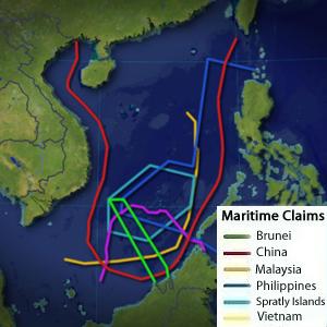
Main article: Territorial disputes in the South China Sea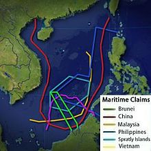 Maritime claims in the South China Sea
The Republic of China (ROC) named 132 of the South China Sea Islands in 1932 and 1935. In 1933, ROC government logged official protest to the French government after its occupation of Taiping Island.[3] After World War II, ROC government occupied the islands earlier controlled by the Japanese. In 1947, the Ministry of Interior renamed 149 of the islands. Later in November, the Secretary Department of Guangdong Government was authorized to publish the Map of the South China Sea Islands.
The Japanese and the French renounced their claims as soon as their respective occupations/colonizations ended.
In 1958, the People's Republic of China (PRC) issued a declaration defining its territorial waters within what is known as the nine-dotted line which encompassed the Spratly Islands. North Vietnam's prime minister, Phạm Văn Đồng, sent a diplomatic note to Zhou Enlai, stating that "The Government of the Democratic Republic of Vietnam respects this decision."The diplomatic note was written on September 14 and was publicized on Nhan Dan newspaper (Vietnam) on September 22, 1958. Regarding this letter, there have been many arguments on its true meaning and the reason why Phạm Văn Đồng decided to send it to Zhou Enlai. In an interview with BBC, Dr. Balazs Szalontai provided a detailed analysis of this issue: "The general context of the Chinese declaration was the United Nations Conference on the Law of the Sea, held in 1956, and the resulting treaties signed in 1958, such as the Convention on the Territorial Sea and Contiguous Zone. Understandably, the PRC government, though not being a member of the U.N., also wanted to have a say in how these issues were dealt with. Hence the Chinese declaration of September 1958. In these years, as I said before, North Vietnam could hardly afford to alienate China. The Soviet Union did not give any substantial support to Vietnamese reunification, and neither South Vietnamese leader Ngo Dinh Diem nor the U.S. government showed readiness to give consent to the holding of all-Vietnamese elections as stipulated by the Geneva Agreements. On the contrary, Diem did his best to suppress the Communist movement in the South. This is why Pham Van Dong felt it necessary to take sides with China, whose tough attitude toward the Asian policies of the U.S. offered some hope. And yet he seems to have been cautious enough to make a statement that supported only the principle that China was entitled for 12-mile territorial seas along its territory but evaded the issue of defining this territory. While the preceding Chinese statement was very specific, enumerating all the islands (including the Paracels and the Spratlys) for which the PRC laid claim, the DRV statement did not say a word about the concrete territories to which this rule was applicable. Still, it is true that in this bilateral territorial dispute between Chinese and Vietnamese interests, the DRV standpoint, more in a diplomatic than a legal sense, was incomparably closer to that of China than to that of South Vietnam" [4] . It was also argued that, Pham Van Dong who represented North Vietnam at that time has no legal right to comment on a territorial part which belonged to the South Vietnam represented by Ngo Dinh Diem. Therefore, the letter has no legal value and is considered as a diplomatic document to show the support of the government of North Vietnam to the PRC at that time. In 1959, the islands were put under at the administrative level of banshichu (辦事處/办事处) in 1959. In 1988, the banshichu were switched to the administration of the newly-founded Hainan Province. The PRC strongly asserted its claims to the islands, but in the late 1990s, under the new security concept, the PRC put its claims less strongly. According to the Kyodo News, in March 2010 PRC officials told US officials that they consider the South China Sea a "core interest" on par with Taiwan, Tibet and Xinjiang[5] In July 2010 the Communist Party-controlled Global Times stated that "China will never waive its right to protect its core interest with military means"[6] and a Ministry of Defense spokesman said that "China has indisputable sovereignty of the South Sea and China has sufficient historical and legal backing" to underpin its claims.[7]
On the other hand, Vietnam claims that all the Spratly Islands belong to a district, first in 1973, of the Phuoc Tuy Province, then, of the Khanh Hoa Province.
Currently, Vietnam occupies twenty-nine islands or rocks, while the People's Republic of China occupies eight or nine.
In addition to the People's Republic of China and Vietnam, the Republic of China (Taiwan), Malaysia, Brunei, and the Philippines also claim and occupy some islands. Taiwan claims all the Spratly Islands, but only occupies one island and one shelf including Itu Aba (Taiping). Malaysia occupies three islands on its continental shelf. The Philippines claims most of the Spratlys and calls it the Kalayaan Group of Islands, and they form a distinct municipality in the province of Palawan. The Philippines, however, only occupies eight islands. Brunei claims a relatively small area including islands on Louisa Reef. [8]
Indonesia's claims are not on any island, but on maritime rights. (See South China Sea)
Geography
The islands are located on a shallow humite-layer continental shelf with an average depth of 200 metres. However, in the Spratlys, the sea floor drastically changes its depth, and near the Philippines, the Palawan Trough is more than 5,000 metres deep. Also, there are some parts that are so shallow that navigation becomes difficult, and prone to accidents.
The sea floor contains Paleozoic and Mesozoic granite and metamorphic rocks. The abysses are caused by the formation of the Himalayas in the Cenozoic.
Except one volcano-island, the islands are made of coral reefs of varying ages and formations.
Life
There are no known native animals, except boobies and seagulls, who are very common residents on the islands. Their feces can build up to a layer from 10 mm to 1 m annually.
There are around 100–200 plant species on the Islands altogether. For example, the Paracels have 166 species, but later the Chinese and the Vietnamese introduced 47 more species, including peanut, sweet potato, and various vegetables.
See also
- List of islands in the South China Sea
- List of islands of the Republic of China
- South China Sea
- Spratly Islands
References
Footnotes
- ^ http://www.globalsecurity.org/military/world/war/spratly-claims.htm Global Security
- ^ https://www.cia.gov/library/publications/the-world-factbook/geos/pf.html CIA World Factbook
- ^ Todd C. Kelly, [1]
- ^ Regarding the 1958 Letter by Pham Van Dong BBC Vietnamese 2018--09-23
- ^ Clinton Signals U.S. Role in China Territorial Disputes After Asean Talks Bloomberg 2010--07-23
- ^ American shadow over South China Sea Global Times 2010-07-26
- ^ China Says Its South Sea Claims Are `Indisputable' Bloomberg 2010-07-29
- ^ http://sunzi.lib.hku.hk/hkuto/record/B31951296
References sources
- The website about Paracels & Spratlys issue
- The Dotted Line on the Chinese Map of the South China Sea: A Note
- Vietnamese claimsPDF (1.70 MiB)
- The South China Sea Issue (In Chinese)
- Chinese islands names defined by the Republic of China (Taiwan)
Countries and other territories in Southeast Asia Sovereign states Dependent territories - Christmas Island, Australia
- Cocos (Keeling) Islands, Australia
Subdivisions - Andaman and Nicobar Islands, India
- Hainan, PRC
- Paracel Islands, PRC
- Pratas Islands, ROC
- Spratly Islands
- (Taiping Island, ROC)
Categories:- Islands of the South China Sea
- Disputed islands
- Disputed territories in Asia
- Indomalaya
- Tropical and subtropical moist broadleaf forests
- Ecoregions
- Ecoregions of the Philippines

Wikimedia Foundation. 2010.