- Vulkaneifel
-
For the mountainous natural region it is named after, see Vulkan Eifel.
Landkreis Vulkaneifel — District — 
Country  Germany
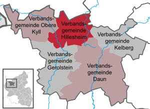
State Rhineland-Palatinate Capital Daun Area – Total 911.01 km2 (351.7 sq mi) Population (31 December 2010)[1] – Total 61,267 – Density 67.3/km2 (174.2/sq mi) Time zone CET (UTC+1) – Summer (DST) CEST (UTC+2) Vehicle registration DAU Website kreis-daun.de Vulkaneifel is a district (Kreis) in the northwest of the state Rhineland-Palatinate, Germany. It is the least densely populated district in the state and the fourth most sparsely populated district on Germany. The administrative centre of the district is in Daun. Neighboring districts are Euskirchen (North Rhine-Westphalia), Ahrweiler, Mayen-Koblenz, Cochem-Zell, Bernkastel-Wittlich, and Bitburg-Prüm.
Contents
History
The district was created in 1815 when the Eifel became part of Prussia. As most of the local industries had their traditional markets in France, the district fell into a severe economic crisis. The construction of a railroad in the second half of the 19th century helped it to recover. The construction of the Nürburgring in 1927 was also an infrastructural project that helped the local economy. The district was enlarged significantly in 1970-71, when the districts Mayen and Prüm were dissolved and parts were added to the Daun district.
On January 1, 2007 the district Daun was renamed Vulkaneifel, the name of the landscape.
Geography
The district is located in the Eifel mountains, containing volcanic lakes called Maar. The largest river in the district is the Kyll.
The Vulkaneifel consists of three regions: Vulkanische Osteifel (municipalities of Brohltal, Vordereifel, Mendig, Pellenz), Vulkanische Hocheifel (municipalities of Adenau, Kelberg, Ulmen, and the village of Nohn), and Vulkanische Westeifel (remainder of the municipality of Hillesheim, and municipalities Obere Kyll, Gerolstein, Manderscheid, Daun).
Tourism
Places of interest in the Vulkaneifel include the maar lakes around Daun, and Manderscheid, as well as the caldera lake of Laacher See at the abbey of Maria Laach, which is the largest, and the youngest within the region. Hiking and cycling trails dot the region.
Museums in the Vulkaneifel include the Lava-Dome (the German volcanic museum) in Mendig, the Vulkanhaus in Strohn, and the Eifel-Vulkanmuseum in Daun.
The Vulkaneifel contains three geological parks (2004,45 km²), the Vulkanpark Brohltal/Laacher See, the Vulkanpark Osteifel, and the Vulkaneifel European Geopark.
 Courtyard of the Castle of Lissingen
The Castle of Eltz and the Castle of Lissingen are well preserved castles in the Vulkaneifel.
Coat of arms
The coat of arms show the symbols of three territories which historically made up the district. In the left is the cross of Trier, the lion in the right represents the Counts of Blankenheim-Gerolstein. The escutcheon in the middle show the arms of the Counts of Daun. Towns and municipalities
References
- ^ "Bevölkerung der Gemeinden am 31.12.2010" (in German). Statistisches Landesamt Rheinland-Pfalz. 31 December 2010. http://www.statistik.rlp.de/fileadmin/dokumente/berichte/A1033_201022_hj_G.pdf.
External links
- Official website (German)
 Urban and rural districts in the State of Rhineland-Palatinate in Germany
Urban districts Frankenthal · Kaiserslautern · Koblenz · Landau · Ludwigshafen · Mainz · Neustadt · Pirmasens · Speyer · Trier · Worms · ZweibrückenRural districts Ahrweiler · Altenkirchen · Alzey-Worms · Bad Dürkheim · Bad Kreuznach · Bernkastel-Wittlich · Birkenfeld · Bitburg-Prüm · Cochem-Zell · Donnersbergkreis · Germersheim · Kaiserslautern · Kusel · Mainz-Bingen · Mayen-Koblenz · Neuwied · Rhein-Hunsrück-Kreis · Rhein-Lahn-Kreis · Rhein-Pfalz-Kreis · Südliche Weinstraße · Südwestpfalz · Trier-Saarburg · Vulkaneifel · WesterwaldkreisCategories:- Districts of Rhineland-Palatinate
- Vulkaneifel district


Wikimedia Foundation. 2010.