- Mukteshwar
-
Mukteshwar — city — Coordinates 29°28′20″N 79°38′52″E / 29.4722°N 79.6479°ECoordinates: 29°28′20″N 79°38′52″E / 29.4722°N 79.6479°E Country India State Uttarakhand District(s) Nainital Time zone IST (UTC+05:30) Area
• 2,171 metres (7,123 ft)
Mukteshwar is a town and tourist destination in the Nainital district of Uttarakhand, India. It sits high in the Kumaon Hills at an altitude of 2286 meters (7500 feet), 51 km from Nainital, 72 km from Haldwani, and 395 km from Delhi.
Contents
Local attractions
Mukteshwar gets its name from an 350-year-old temple to Shiva, known as Mukteshwar Dham, situated atop the highest point in the town, within the IVRI campus, and close to which lie the overhanging cliffs, locally known as Chauli-ki-Jali, used for rock climbing and rappelling, with an excellent view of the valleys below. The sunrise point is at the government-run PWD Guest House. One can also visit the Indian Veterinary Research Institute. IVRI hostels and the PWD resthouse were the prominent shelters for ages. Now, KMVN operates a Tourist Rest house (can be booked from Delhi as well as on Phone / Wireless from other KMVN guest houses). Several other hotels, resorts, guest houses and seasonal tent / hut based camps come up. Valley Unwind Resort is one of the best resort for various eco-tour activities around the valley. Nice scenery can be viewed from Chaulli ki Jaali, where rocks jut out from the hill face at a bizarre angle. This is a great place to observe eagles and other feathered scavengers as they swoop down at their prey.[1] IVRI laboratories (experiments on tiny rats, gold plated books, cattle-sheds), 16 mile x 14 mile wide Deodar forest, prestine 22 snow-peaks view, advanture of living among wildlife like tigers and bears, are some of the major attractions of this sleepy town. Mukteshwar is abode of a saint - Shri Mukteshwar Maharaj ji - who lived at the Top Cottage Temple where his samadhi is situated. One of his disciple - Swami Sanshudhanand ji - now stays there. Whole temple complex is a Tapovan, and an ideal place for meditation. Charm of visiting Mukteshwar lies in enjoying nature, listening to air gushing through deodar forests, bird watching, meditation, and seeking peace. If you are the city dwelling, club hopping, TV-Multiplex-Mall addicted type, then give this place a miss, the cleanliness, solitude and nature will bore you.
History
Till 1893 the place was known for its shrines and temple before it was selected for serum production to protect animals from cattle plague. [2] On the recommendation of the Cattle Plague Commission, the Institute then known as the Imperial Bacteriological Laboratory had its genesis on December 9, 1889 at Pune, and later relocated to Mukteshwar in 1893 [3] to facilitate segregation and quarantine of highly contagious organisms. Initially the laboratory at Mukteshwar was completed in 1898 but destroyed by fire in 1899. It has been resurrected again in 1901. Then annual expenditure on the research was Rs. 50,000. [4] Later it was developed into the Indian Veterinary Research Institute (IVRI), which later moved its headquarters to Izatnagar. Still Mukteshwar serves as the hill campus of IVRI, including various facilities such as an experimental goat farm.[5][6] The noted nobel winner scientist Robert Koch visited this place on request of then GOI. The microscope used by him and other historical articles are kept in the museum maintained by IVRI. Hill carved cold room in 1900 is a place of attraction for visitors. It was made to store biological materials then.
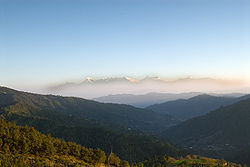 Mukteshwar, a view of the Himalayas.
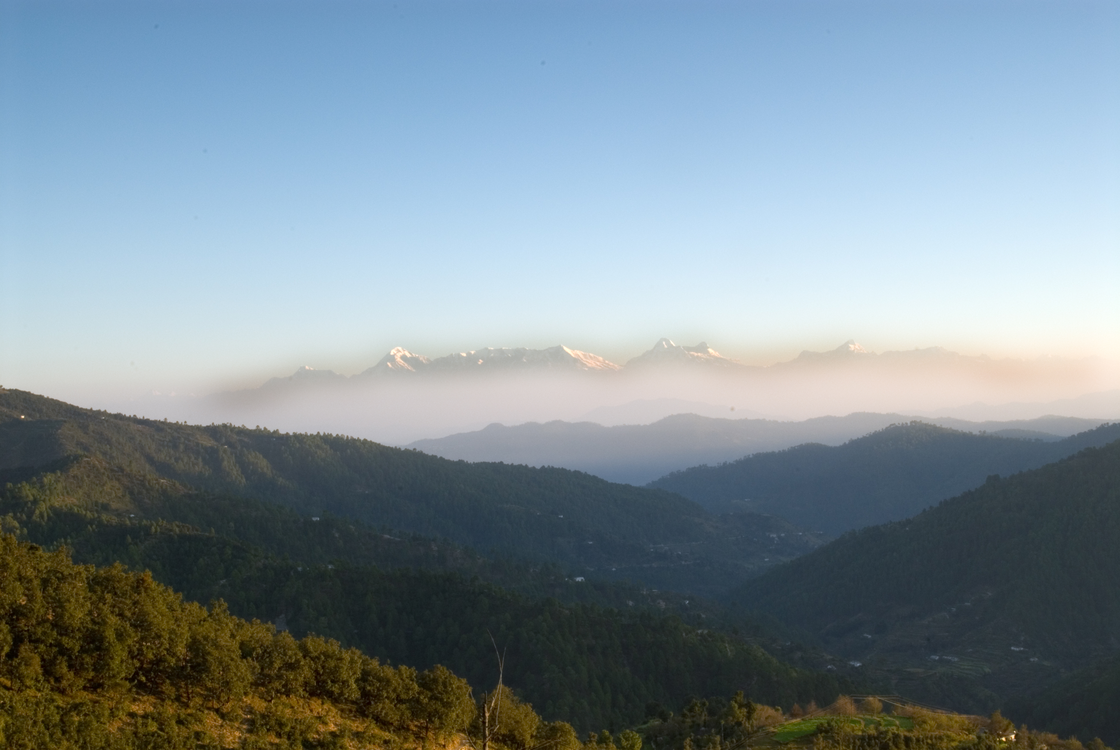
Because of the hilly topography, agriculture in the area consists chiefly of potato fields and fruit orchards on terraces cut into the hillsides.
Robert Koch visited IVRI Mukteshwar to work on cattle plague.
Famous saviour of horror stricken people of mountains from Man-eating tiger and writer Jim Corbett visited Mukteshwar. He wrote a story of Man-Eater tiger of Mukteshwar in one of his books[7]. Jim Corbett had given befitting and thrilling account of his experiences in the jungle. His books can be freely downloaded from internet archives.[8] [9] [10] [11]
Geography
Mukteshwar is located at 29°28′20″N 79°38′52″E / 29.4722°N 79.6479°E.[12] It has an average elevation of 2,171 metres (7,123 feet).
Mukteshwar is rich in scenic beauty, with magnificent views of the Indian Himalayas including India's second-highest peak, Nanda Devi.
Kumaon Vani
With the aim to create a common platform for local communities of Supi in Uttarakhand, TERI launched 'Kumaon vani', a community radio service on March 11, 2010. Uttarakhand Governor Margaret Alva inaugurated the community radio station, the first in the state. The 'Kumaon Vani' aims to air programmes on environment, agriculture, culture, weather and education in the local language and with the active participation of the communities. The radio station covers a radius of 10 km reaching out to almost 2000 locals around Mukteshwar[13]
New development
There is also a 'Renewable Park' developed by TERI. The renewable park uses solar electricity for most of its electricity needs. Recently, the town has experienced some construction activity and townships have begun to mushroom in and around Mukteshwar. Many people are buying holiday homes here to escape large chaotic cities.
Transport
The nearest airport is at Pantnagar, and nearest railway head is at Kathgodam, 65 km from the town, from where vehicular transport is easily available, as from neighbouring towns of Bhimtal, Bhowali, and Nainital.
References
- ^ Mukteshwar
- ^ Imperial Gazetteer of India, Volume 18, Page 18
- ^ Mukteshwar Official website of Nainital district
- ^ Imperial Gazetteer of India, Volume 18, Page 18
- ^ Evolution of IVRI Indian Veterinary Research Institute Official website.
- ^ Campuses Indian Veterinary Research Institute Official website.
- ^ http://www.archive.org/details/TheTempleTigerAndMoreMan-eatersOfKumaon1954
- ^ http://www.archive.org/details/TheTempleTigerAndMoreMan-eatersOfKumaon1954
- ^ http://www.archive.org/details/maneatersofkumao029903mbp
- ^ http://www.archive.org/details/JungleLore
- ^ http://www.archive.org/details/TheMan-eatingLeopardOfRudraprayag1947
- ^ Falling Rain Genomics, Inc - Mukteshwar
- ^ http://news.oneindia.in/2010/03/13/terilaunches-kumaon-vani-community-radio-service.html
External links
Cities and towns in Nainital district Nainital Cities and towns
in other districtsAlmora · Bageshwar · Chamoli · Champawat · Dehradun · Haridwar · Pauri Garhwal · Pithoragarh · Rudraprayag · Tehri Garhwal · Udham Singh Nagar · Uttarkashi
Categories:- Cities and towns in Nainital district
- Tourism in Uttarakhand
- Hill stations in India
- Nainital


Wikimedia Foundation. 2010.