- Dantewada district
-
This article is about the district. For its eponymous headquarters, see Dantewada.
Dantewada district
दन्तेवाड़ा जिला
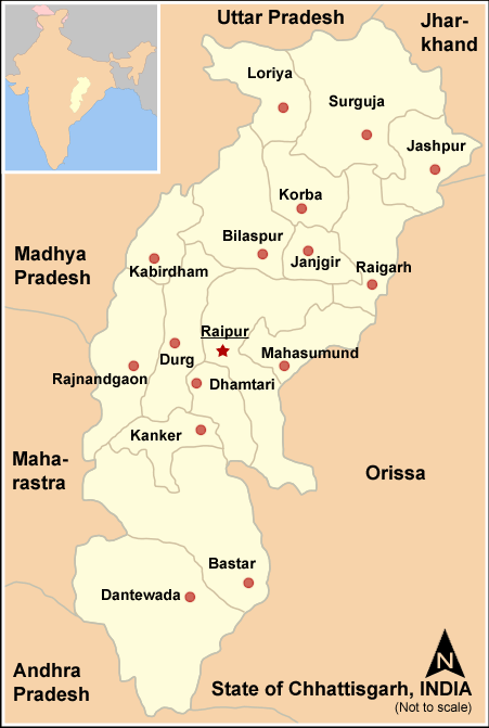
Location of Dantewada district in ChhatisgarhState Chhatisgarh,  India
IndiaAdministrative division Bastar Headquarters Dantewada Area 9,046.29 km2 (3,492.79 sq mi) Population 478,319 (2001) Population density 45 /km2 (120 /sq mi) Literacy 32 per cent Tehsils 7 Official website Dantewada District, also known as Dantewara District or Dakshin Bastar District (South Bastar District), is a district in the Indian state of Chhattisgarh. Dantewada is the district headquarters. The district is part of Bastar Division. Until 1998, the Dantewada District was a tehsil of the larger Bastar District.
As of 2011 it is the third least populous district of Chhattisgarh (out of 18), after Narayanpur and Bijapur.[1]
Contents
History
Before Indian Independence, the district was part of the princely state of Bastar. After Indian Independence in 1947, Bastar's ruler acceded to the government of India, and the erstwhile state became part of Bastar District of Madhya Pradesh state. Bastar District was divided into the districts of Bastar, Dantewada, and Kanker in 1999. In 2000, Dantewada was one of the 16 Madhya Pradesh districts that constituted the new state of Chhattisgarh. Dantewada has further been bifurcated in the year 2007 resulting into a new district Bijapur with 4 Tehsils namely Bijapur, Bhairamgarh, Usoor & Bhopalpatnam.
Maoist rebellion
The district is currently a part of the Red Corridor.[2] Over the last year, more than 350 people have been killed and 50,000 moved into camps in the Dantewada district, as a result of a Maoist uprising. The uprising was triggered by the formation in 2005 of Salwa Judum, an anti-Maoist movement.[3]
In April 2010, the Maoist rebels killed at least 75 Indian soldiers in a series of attacks on security convoys in Dantewada.[4] In May 2010, the Naxals targeted the Special Police Officers traveling in a civilian bus, killing around 31[5] to 44,[6] including several Special Police Officers (SPOs) and civilians.[7]
Geography
Dantewada District has an area of 10,238.99 km². It is bounded on the north and northeast by Bastar District, on the east by Malkangiri District of Orissa state, on the south and southwest by Khammam District of Andhra Pradesh state, and on the west by the Indravati River, which forms the boundary with Karimnagar District of Andhra Pradesh and Gadchiroli District of Maharashtra.
Demographics
According to the 2011 census Dantewada district has a population of 532,791,[1] roughly equal to the nation of Cape Verde.[8] This gives it a ranking of 540th in India (out of a total of 640).[1] The district has a population density of 59 inhabitants per square kilometre (150 /sq mi) .[1] Its population growth rate over the decade 2001-2011 was 11.9 %.[1] Dantewada has a sex ratio of 1022 females for every 1000 males,[1] and a literacy rate of 42.67 %.[1]
The district has a population of 719,065 (2001 census), of which 476,945 (66%) are tribal peoples (adivasis). The district is divided into 7 tehsils, Dantewada, Gidam, Kuwakonda, Katekalyan, Chhindgarh, Sukma, and Konta.
Education
Dantewada, with a literacy rate of 30.17%, is the least literate district in India. It is also the district having the lowest male literacy rate in India (39.75%).
References
- ^ a b c d e f g "District Census 2011". Census2011.co.in. 2011. http://www.census2011.co.in/district.php. Retrieved 2011-09-30.
- ^ "83 districts under the Security Related Expenditure Scheme". IntelliBriefs. 2009-12-11. http://intellibriefs.blogspot.com/2009/12/naxal-menace-83-districts-under.html. Retrieved 2011-09-17.
- ^ * A spectre haunting India, the Economist Volume 380 Number 8491 August 19th-25th 2006
- ^ Scores of Indian soldiers killed in Maoist ambushes. BBC. 6 April 2010.
- ^ http://www.ndtv.com/news/india/dantewada-bus-blast-toll-30-pm-to-review-naxal-strategy-26185.php?u=1439
- ^ "Talks with Maoists if they suspend violence: Chidambaram". The Times Of India. 18 May 2010. http://timesofindia.indiatimes.com/india/Talks-with-Maoists-if-they-suspend-violence-Chidambaram/articleshow/5945211.cms.
- ^ "Naxals blow up bus near Dantewada, 50 feared killed". NDTV. 17 May 2010. http://www.ndtv.com/news/india/naxals-blow-up-bus-near-dantewada-50-feared-killed-26110.php.
- ^ US Directorate of Intelligence. "Country Comparison:Population". https://www.cia.gov/library/publications/the-world-factbook/rankorder/2119rank.html. Retrieved 2011-10-01. "Cape Verde 516,100 July 2011 est."
External links

Bijapur district Narayanpur district Bastar district
Koraput district, Orissa
 Dantewada district

Khammam district, Andhra Pradesh Malkangiri district, Orissa Cities and towns in Dantewada district Dantewada Bade Bacheli · Dantewada · Geedam · Kirandul
Cities and towns
in other districtsBastar · Bilaspur · Dhamtari · Durg · Jangir-Champa · Jashpur · Kabirdham · Kanker · Korba · Koriya · Mahasamund · Raigarh · Raipur · Rajnandgaon · Surguja
Districts of Chhattisgarh Bastar · Bijapur · Bilaspur · Dantewada · Dhamtari · Durg · Janjgir Champa · Jashpur · Kabirdham · Kanker · Korba · Koriya · Mahasamund · Narayanpur · Raigarh · Raipur · Rajnandgaon · Surguja
Capital: RaipurCategories:
Wikimedia Foundation. 2010.