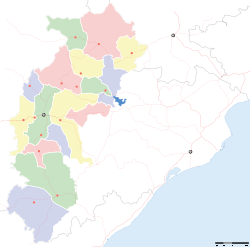
Deori, Bilaspur district

Deori, Bilaspur district

See Deori for disambiguation

Deori
—  city  —
Deori
Location of Deori
in Chhattisgarh and India
Coordinates 21°27′N 82°37′E / 21.45°N 82.62°E / 21.45; 82.62Coordinates: 21°27′N 82°37′E / 21.45°N 82.62°E / 21.45; 82.62
Country India
State Chhattisgarh
District(s) Bilaspur
Population 11,636 (2001)
Time zone IST (UTC+05:30)
Area

Elevation


247 metres (810 ft)

Deori is a census town in Bilaspur district in the state of Chhattisgarh, India.

Geography

Deori is located at 21°27′N 82°37′E / 21.45°N 82.62°E / 21.45; 82.62[1]. It has an average elevation of 247 metres (810 feet).

Demographics

As of 2001 India census[2], Deori had a population of 11,636. Males constitute 52% of the population and females 48%. Deori has an average literacy rate of 62%, higher than the national average of 59.5%: male literacy is 72% and, female literacy is 52%. In Deori, 16% of the population is under 6 years of age.

References


Wikimedia Foundation. 2010.

Игры ⚽ Поможем решить контрольную работу

Look at other dictionaries:

  • Deori, Bilaspur — See Deori for disambiguation Infobox Indian Jurisdiction native name = Deori | type = city | latd = 21.45 | longd = 82.62 locator position = right | state name = Chhattisgarh district = Bilaspur leader title = leader name = altitude = 247… …   Wikipedia

  • Deori — may refer to: Deori, Bilaspur district, a town in Chhattisgarh Deori, Gondia, a town in Maharashtra Deori, Sagar, a town in Madhya Pradesh Deori, Shahdol, a town in Madhya Pradesh Deori block in Giridih district, Jharkhand Deori people of… …   Wikipedia

  • Dindori District — This article is about the district. For its eponymous headquarters, see Dindori. Dindori district दिन्डोरी जिला …   Wikipedia

  • Villages in the district Pilibhit — Villages in District Pilibhit= There are 1227 Villages in the district Pilibhit in four tehsils and seven blocks. The tehsils are Pilibhit, Barkhera, Puranpur, Bisalpur. The blocks in the district Pilibhit are Amaria, Barkhera, Bilsanda, Bisalpur …   Wikipedia

  • List of India-related articles — Articles (arranged alphabetically) related to India or Indian culture include: NOTOC List of India related topics People are listed by their first names. 1231 SGM 3 STR 2002 Gujarat violence 2005 in India ( previous years ) 2004 Indian Ocean… …   Wikipedia

  • Index of India-related articles — Articles (arranged alphabetically) related to India or Indian culture include: List of India related topics Contents: Top · 0–9 A B C D E F G H I J K L M N O P Q R S T U V W X Y Z People are listed by their first names …   Wikipedia

  • Mehmand —   city   Coordinates Country India State Chhattisgarh …   Wikipedia

  • Mungeli —   city   …   Wikipedia

  • List of Scheduled Tribes in India — This is a full list of Scheduled Tribes in India, as recognised in India s Constitution; a total of 645 district tribes. The term Scheduled Tribes refers to specific indigenous peoples whose status is acknowledged to some formal degree by… …   Wikipedia

  • National Highway 6 ( India ) — National Highway 6, commonly referred to as NH 6, is a busy freeway that runs through of south Gujarat, Maharashtra, Chhattisgarh, Orissa, Jharkhand and West bengal state in India. The freeway touches the cities of Surat, Dhule, Nagpur, Raipur,… …   Wikipedia

Share the article and excerpts

Direct link
Do a right-click on the link above
and select “Copy Link”