- Nakagawa-ku, Nagoya
-
Nakagawa-ku
中川区— Ward — Matsushige Rock Gate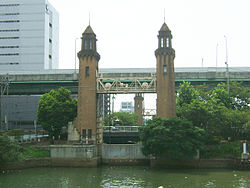 Location of Nakagawa-ku in Aichi Prefecture
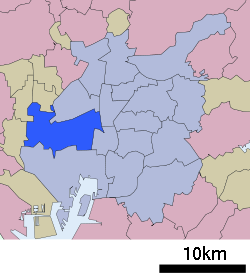

 Nakagawa-ku
Coordinates: 35°8′30″N 136°51′18″E / 35.14167°N 136.855°ECoordinates: 35°8′30″N 136°51′18″E / 35.14167°N 136.855°E Country Japan Region Chūbu region
Tōkai regionPrefecture Aichi Prefecture Area - Total 32.03 km2 (12.4 sq mi) Population (September 2011 [1]) - Total 221,751 - Density 6,909/km2 (17,894.2/sq mi) Time zone Japan Standard Time (UTC+9) City symbols - Tree Japanese Black Pine - Flower Ornamental cabbage [2] Phone number 052-362-1111 Address 愛知県名古屋市中川区高畑一丁目223
454-8501Website city.nagoya.jp/nakagawa/ (Japanese) Nakagawa (中川区 nakagawaku) is one of the 16 wards of the city of Nagoya in Aichi Prefecture, Japan.
References
- ^ "平成23年9月1日現在の世帯数と人口(全市・区別)" (in Japanese). Nagoya City. 20 September 2011. http://www.city.nagoya.jp/somu/page/0000028476.html.
- ^ "中川区の紹介" (in Japanese). Nagoya City. 1 October 2007. http://www.city.nagoya.jp/nakagawa/page/0000001962.html.
 Aichi Prefecture
Nagoya (capital city) 
Other cities Aisai | Ama | Anjō | Chiryū | Chita | Gamagōri | Handa | Hekinan | Ichinomiya | Inazawa | Inuyama | Iwakura | Kariya | Kasugai | Kitanagoya | Kiyosu | Komaki | Kōnan | Miyoshi | Nishio | Nisshin | Okazaki | Ōbu | Owariasahi | Seto | Shinshiro | Tahara | Takahama | Tokoname | Tōkai | Toyoake | Toyohashi | Toyokawa | Toyota | Tsushima | YatomiAichi District Ama District Chita District Kitashitara District Nishikasugai District Niwa District Nukata District 
This Aichi Prefecture location article is a stub. You can help Wikipedia by expanding it.


