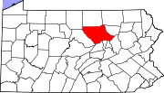
- Oval, Pennsylvania
-
Oval is a census-designated place (CDP) in Limestone Township in Lycoming County, in the U.S. state of Pennsylvania.[1] Oval is not a separately incorporated community, but is a part of Limestone Township (which is a municipality under Pennsylvania law). Oval is on Pennsylvania Route 44 and is completely surrounded by Limestone Township is southwest Lycoming County.[2][3]
References
- ^ U.S. Geological Survey Geographic Names Information System: Oval, Pennsylvania
- ^ United States Department of Commerce, Bureau of the Census (2011). 2011 BOUNDARY AND ANNEXATION SURVEY (BAS): Lycoming County, PA (Map). http://www2.census.gov/geo/pvs/bas/bas11/st42_pa/cou/c42081_lycoming/BAS11C24208100000_070.pdf. Retrieved February 13, 2011.
- ^ United States Department of Commerce, Bureau of the Census (2011). 2011 BOUNDARY AND ANNEXATION SURVEY (BAS): Lycoming County, PA (Map). http://www2.census.gov/geo/pvs/bas/bas11/st42_pa/cou/c42081_lycoming/BAS11C24208100000_071.pdf. Retrieved February 13, 2011.
Municipalities and communities of Lycoming County, Pennsylvania City Boroughs Townships Anthony | Armstrong | Bastress | Brady | Brown | Cascade | Clinton | Cogan House | Cummings | Eldred | Fairfield | Franklin | Gamble | Hepburn | Jackson | Jordan | Lewis | Limestone | Loyalsock | Lycoming | McHenry | McIntyre | McNett | Mifflin | Mill Creek | Moreland | Muncy Creek | Muncy | Nippenose | Old Lycoming | Penn | Piatt | Pine | Plunketts Creek | Porter | Shrewsbury | Susquehanna | Upper Fairfield | Washington | Watson | Wolf | Woodward
CDPs Faxon | Garden View | Kenmar | Oval | Rauchtown‡
Unincorporated
communitiesGhost town Footnotes ‡This populated place also has portions in an adjacent county
Coordinates: 41°09′04″N 77°10′09″W / 41.15111°N 77.16917°W
Categories:- Census-designated places in Lycoming County, Pennsylvania
- Pennsylvania geography stubs
Wikimedia Foundation. 2010.

