- Fairfield Township, Lycoming County, Pennsylvania
Infobox Settlement
official_name = Fairfield Township,
Lycoming County,
Pennsylvania
other_name =
native_name =
nickname =
settlement_type = Township
motto =
imagesize =
image_caption = Old stone barn in Fairfield Township, from PA 87
flag_size =
image_
seal_size =
image_shield =
shield_size =
image_blank_emblem =
blank_emblem_size =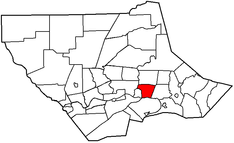
mapsize = 250x200px
map_caption = Map of Lycoming County, Pennsylvania highlighting Fairfield Township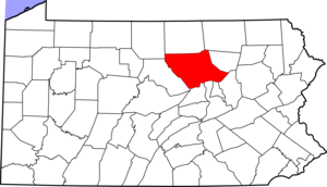
mapsize1 = 250x200px
map_caption1 = Map of Lycoming County, Pennsylvania
subdivision_type = Country
subdivision_name =United States
subdivision_type1 = State
subdivision_name1 =Pennsylvania
subdivision_type2 = County
subdivision_name2 = Lycoming
subdivision_type3 =
subdivision_name3 =
subdivision_type4 =
subdivision_name4 =
government_footnotes =
government_type =
leader_title =
leader_name =
leader_title1 =
leader_name1 =
leader_title2 =
leader_name2 =
leader_title3 =
leader_name3 =
leader_title4 =
leader_name4 =
established_title = Settled
established_date = 1742
established_title2 = Formed
established_date2 = 1825 or 1826
established_title3 =
established_date3 =
area_magnitude =
unit_pref = Imperial
area_footnotes =
area_total_km2 = 30.4
area_land_km2 = 30.1
area_water_km2 = 0.3
area_total_sq_mi = 11.7
area_land_sq_mi = 11.6
area_water_sq_mi = 0.1
area_water_percent = 1.02
area_urban_km2 =
area_urban_sq_mi =
area_metro_km2 =
area_metro_sq_mi =
area_blank1_title =
area_blank1_km2 =
area_blank1_sq_mi =
population_as_of = 2000
population_footnotes =
population_note =
population_total = 2659
population_density_km2 = 88.4
population_density_sq_mi = 228.8
population_metro =
population_density_metro_km2 =
population_density_metro_sq_mi =
population_urban =
population_density_urban_km2 =
population_density_urban_sq_mi =
population_blank1_title =
population_blank1 =
population_density_blank1_km2 =
population_density_blank1_sq_mi =
timezone = Eastern Time Zone (North America)
utc_offset = -5
timezone_DST = EDT
utc_offset_DST = -4
latd = 41 |latm = 15 |lats = 17 |latNS = N
longd = 76 |longm = 52 |longs = 35 |longEW = W
elevation_footnotes =
elevation_m = 197
elevation_ft = 646
postal_code_type =
postal_code =
area_code =
blank_name = FIPS code
blank_info = 42-24592GR|2
blank1_name = GNIS feature ID
blank1_info = 1216748GR|3
website =
footnotes =Fairfield Township is a township in Lycoming County,
Pennsylvania , in the United States. The population was 2,659 at the 2000 census. It is part of the Williamsport, PennsylvaniaMetropolitan Statistical Area .History
The exact date of the formation of Fairfield Township is not known, but court records point to sometime between August 1825 and December 1826. A petition for the division of Muncy Township was read in court in August 1825. Historical records do not record when the township was formed, but court documents cite Fairfield Township as the residence of a
defendant in a lawsuit in a Columbia County court session in 1826.cite book
last = Meginness
first = John Franklin
title = History of Lycoming County, Pennsylvania: including its aboriginal history; the colonial and revolutionary periods; early settlement and subsequent growth; organization and civil administration; the legal and medical professions; internal improvement; past and present history of Williamsport; manufacturing and lumber interests; religious, educational, and social development; geology and agriculture; military record; sketches of boroughs, townships, and villages; portraits and biographies of pioneers and representative citizens, etc. etc."
origdate = 1892
url = http://www.usgennet.org/usa/pa/county/lycoming/history/lyco-history-01.html
accessdate = 2007-04-17
edition = 1st Edition
publisher = Brown, Runk & Co.
location = Chicago, IL
id = ISBN 0-7884-0428-8
chapter =
chapterurl = http://www.usgennet.org/usa/pa/county/lycoming/history/Chapter-34.html
quote = (Note: ISBN refers to Heritage Books July 1996 reprint. URL is to a scan of the 1892 version with some OCR typos).]John Andrew Shulze retired to Fairfield Township following his 1823-1829 term as Pennsylvania'sgovernor . Shulze bought 500 acres in western Fairfield Township, now part of Montoursville for $12,000. His plan was to spend his retirement farming in theWest Branch Susquehanna Valley . Shulze quickly made am impact in Fairfield Township. He built a brick house on his farm and donated an acre of land for the construction of Union Church which was shared by theLutheran andPresbyterian congregations of Montoursville and Fairfield Township. Ultimately Shulze's time in Fairfield Township can be described as a sad failure. His repeated attempts at farming were unsuccessful. He also lost a lawsuit filed by William Cameron of Lewisburg for $3,835.49. Shulze was apparently unable to pay the suit and his property was seized and sold to pay his debt. Governor Shulze then took up residence in Montoursiville, lost even more lawsuits and eventually moved to Lancaster in 1846 where he lived until his death in 1852. As of 2007, Schulze's Montoursville home is the "Governor Schulze House"Bed and Breakfast ". [cite web|url=http://www.govshulzehouse.com/| title=Governor Schulze House Bed & Breakfast|accessdate= 2007-09-14]Fairfield Township's population has grown since the 1890 census when 468 citizens were counted. The census of 2000 counted 2,659 citizens. Fairfield Township has many residential neighborhoods that are contiguous with the neighboring borough of Montoursivlle.
Geography
Fairfield Township is bordered by Upper Fairfield Township to the north, Muncy Township to the east and the
West Branch Susquehanna River to the south. The western border is bounded by Montoursville andLoyalsock Creek which forms the border with Loyalsock Township to the west.As the crow flies , Lycoming County is about convert|130|mi|km|0 northwest ofPhiladelphia and convert|165|mi|km|0 east-northeast of Pittsburgh.According to the
United States Census Bureau , the township has a total area of 11.7square mile s (30.4km² ).11.6 square miles (30.1 km²) of it is land and 0.1 square miles (0.3 km²) of it (1.02%) is water.Demographics
As of the
census GR|2 of 2000, there were 2,659 people, 1,020 households, and 781 families residing in the township. Thepopulation density was 228.8 people per square mile (88.4/km²). There were 1,100 housing units at an average density of 94.7/sq mi (36.6/km²). The racial makeup of the township was 97.97% White, 0.60% African American, 0.30% Native American, 0.38% Asian, 0.04% from other races, and 0.71% from two or more races. Hispanic or Latino of any race were 0.53% of the population.There were 1,020 households out of which 35.4% had children under the age of 18 living with them, 65.3% were married couples living together, 7.0% had a female householder with no husband present, and 23.4% were non-families. 18.5% of all households were made up of individuals and 8.0% had someone living alone who was 65 years of age or older. The average household size was 2.61 and the average family size was 2.96.
In the township the population was spread out with 26.2% under the age of 18, 6.5% from 18 to 24, 28.0% from 25 to 44, 25.6% from 45 to 64, and 13.7% who were 65 years of age or older. The median age was 39 years. For every 100 females there were 94.8 males. For every 100 females age 18 and over, there were 93.8 males.
The median income for a household in the township was $43,438, and the median income for a family was $49,570. Males had a median income of $37,034 versus $22,826 for females. The
per capita income for the township was $19,807. About 4.1% of families and 6.4% of the population were below thepoverty line , including 7.9% of those under age 18 and 3.0% of those age 65 or over.References

Wikimedia Foundation. 2010.