- Loyalsock Township, Pennsylvania
Infobox Settlement
official_name = Loyalsock Township, Pennsylvania
settlement_type = Township
nickname =
motto =
imagesize =
image_caption = Loyalsock Creek
image_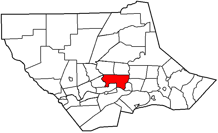
mapsize = 250x200px
map_caption = Map of Lycoming County, Pennsylvania highlighting Loyalsock Township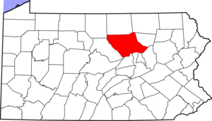
mapsize1 = 250x200px
map_caption1 = Map of Lycoming County, Pennsylvania
subdivision_type = Country
subdivision_name =United States
subdivision_type1 = State
subdivision_name1 =Pennsylvania
subdivision_type2 = County
subdivision_name2 = Lycoming
government_footnotes =
government_type =
leader_title =
leader_name =
leader_title1 =
leader_name1 =
established_title = Settled
established_date = 1768
established_title1 = Incorporated
established_date1 = 1786
unit_pref = Imperial
area_footnotes =
area_magnitude =
area_total_km2 = 55.0
area_land_km2 = 54.4
area_water_km2 = 0.6
area_total_sq_mi = 21.2
area_land_sq_mi = 20.9
area_water_sq_mi = 0.2
population_as_of = 2000
population_footnotes =
population_total = 10876
population_density_km2 = 199.9
population_density_sq_mi = 517.6
timezone = Eastern (EST)
utc_offset =
timezone_DST = EDT
utc_offset_DST =
elevation_footnotes =
elevation_m =
elevation_ft =
latd =
latm =
lats =
latNS = N
longd =
longm =
longs =
longEW =
postal_code_type =
postal_code =
area_code = 570
blank_name =
blank_info =
blank1_name =
blank1_info =
website =
footnotes =Loyalsock Township is a township in Lycoming County,
Pennsylvania , in the United States. The population was 10,876 at the 2000 census. It is part of the Williamsport, PennsylvaniaMetropolitan Statistical Area .History
Loyalsock Township was formed from Muncy Township in February 1786 by the Northumberland County court. This was nine years prior to the formation of Lycoming County. The township was originally bounded by the
West Branch Susquehanna River to the south,Loyalsock Creek was the eastern limit andLycoming Creek was the western limit. As for the northern limit, this was undefined, it may have extended as far north asNew York state. The city of Williamsport was formed in large measure from a great part of Loyalsock Township. Seventy-five percent of Williamsport's lands came from Loyalsock.cite book
last = Meginness
first = John Franklin
title = History of Lycoming County, Pennsylvania: including its aboriginal history; the colonial and revolutionary periods; early settlement and subsequent growth; organization and civil administration; the legal and medical professions; internal improvement; past and present history of Williamsport; manufacturing and lumber interests; religious, educational, and social development; geology and agriculture; military record; sketches of boroughs, townships, and villages; portraits and biographies of pioneers and representative citizens, etc. etc."
origdate = 1892
url = http://www.usgennet.org/usa/pa/county/lycoming/history/lyco-history-01.html
accessdate = 2007-04-25
edition = 1st Edition
publisher = Brown, Runk & Co.
location = Chicago, IL
id = ISBN 0-7884-0428-8
chapter = XLI
chapterurl = http://www.usgennet.org/usa/pa/county/lycoming/history/Chapter-41.html
quote = (Note: ISBN refers to Heritage Books July 1996 reprint. URL is to a scan of the 1892 version with some OCR typos).]In the
American Revolutionary War , settlements throughout the Susquehanna valley and what was to become Loyalsock Township were attacked by Loyalists and Native Americans allied with the British. After theWyoming Valley battle and massacre in the summer of 1778 (near what is now Wilkes-Barre) and smaller local attacks, the "Big Runaway " occurred throughout the West Branch Susquehanna valley. Settlers fled feared and actual attacks by the British and their allies. Homes and fields were abandoned, with livestock driven along and a few possessions floated on rafts on the river east to Muncy, then further south to Sunbury. The abandoned property was burnt by the attackers. Some settlers soon returned, only to flee again in the summer of 1779 in the "Little Runaway".Sullivan's Expedition helped stabilize the area and encouraged resettlement, which continued after the war.Isaac and William McKinney, father and son, built the McKinney Iron Works along Lycoming Creek in western Loyalsock Townshop between 1825 and 1830, when they built a forge, in an area known as Heshbon Park. Their operation was expanded in 1836 with the construction of an iron furnace and further still in 1841 when a rolling mill was added to the complex.
Iron ore was transported down theWest Branch Susquehanna River Valley and up Lycoming Creek to the iron works from Centre County. The McKinney's effort was ultimately unsuccessful. The efforts of two more iron masters also failed. The iron works was largely destroyed by a flood in 1865.Daniel Hughes was a conductor in the
Underground Railroad based in Loyalsock Township. He was the owner of abarge on thePennsylvania Canal and transportedlumber from Williamsport on theWest Branch Susquehanna River to Havre de Grace,Maryland . cite web | url = http://www.dcnr.state.pa.us/polycomm/feb/diversitydiary0299.htm | title | title = Forests & Freedom: Forgotten Links In Pennsylvania's Underground Railroad | accessdate = 2007-06-27 | author = Bob Hill | publisher = "The Resource" a publication of thePennsylvania Department of Conservation and Natural Resources ] Hughes hid runaway slaves in the hold of his barge on his return trip up theSusquehanna River to Lycoming County where he provided shelter on his property near the Loyalsock Township border with Williamsport before moving further north and to eventual freedom inCanada . cite web | url = http://www.historicwilliamsport.com/Features/Daniel%20Hughes.htm | title = Daniel Hughes: Giant of Freedom Road | accessdate = 2007-06-27 | author = Lou Hunsinger Jr. | publisher =Williamsport Sun-Gazette ] Hughes' home was located in a hollow or small valley in the mountains just north of Williamsport. This hollow is now known as Freedom Road having previously been called Nigger Hollow. In response to the actions of concerned African American citizens of Williamsport, thepejorative name was formally changed by the Williamsport City Council in 1936..Today a great part of Loyalsock Township is part of the Williamsport Metropolitan area. The flood plain between Williamsport and Montoursville is densely populated with family homes and a shopping district known as the "Golden Strip" along East Fourth Street. The northern and western parts of the township are less heavily populated but still there are many family homes and small businesses. The population of Loyalsock Township has grown to 10,876 (2000 census) this is up from 2,498 (1890 census).
Geography
Loyalsock Township is bordered by Montoursville, Fairfield and Upper Fairfield Township to the east. These eastern borders are formed by
Loyalsock Creek . The township is bordered by Williamsport and theWest Branch Susquehanna River to the south (with Armstrong Township south of the river). Williamsport also forms the eastern border along withLycoming Creek which is the dividing line between Loyalsock and Old Lycoming Township. The townships of Hepburn and Eldred form the northern border.As the crow flies , Lycoming County is about convert|130|mi|km|0 northwest ofPhiladelphia and convert|165|mi|km|0 east-northeast of Pittsburgh.According to the
United States Census Bureau , the township has a total area of 21.2square mile s (55.0km² ).21.0 square miles (54.4 km²) of it is land and 0.2 square miles (0.6 km²) of it (1.13%) is water.Demographics
As of the
census GR|2 of 2000, there were 10,876 people, 4,501 households, and 2,966 families residing in the township. Thepopulation density was 517.6 people per square mile (199.9/km²). There were 4,687 housing units at an average density of 223.1/sq mi (86.1/km²). The racial makeup of the township was 94.81% White, 2.64% African American, 0.13% Native American, 1.05% Asian, 0.01% Pacific Islander, 0.33% from other races, and 1.03% from two or more races. Hispanic or Latino of any race were 0.86% of the population.There were 4,501 households out of which 26.1% had children under the age of 18 living with them, 53.5% were married couples living together, 9.5% had a female householder with no husband present, and 34.1% were non-families. 31.0% of all households were made up of individuals and 18.9% had someone living alone who was 65 years of age or older. The average household size was 2.25 and the average family size was 2.80.
In the township the population was spread out with 20.7% under the age of 18, 5.0% from 18 to 24, 20.7% from 25 to 44, 24.3% from 45 to 64, and 29.4% who were 65 years of age or older. The median age was 47 years. For every 100 females there were 81.6 males. For every 100 females age 18 and over, there were 76.0 males.
The median income for a household in the township was $36,806, and the median income for a family was $47,952. Males had a median income of $39,623 versus $24,684 for females. The
per capita income for the township was $23,480. About 6.8% of families and 8.7% of the population were below thepoverty line , including 15.7% of those under age 18 and 4.3% of those age 65 or over.Education
[http://www.ltsd.k12.pa.us/ltsd/site/default.asp Loyalsock Township School District] consists of:
*Donald E. Shick Elementary (formerly known as Four Mile Elementary)
*Loyalsock Township Middle School
*Loyalsock Township High School A
Lancer is the mascot for the school district. The school colors are maroon and white.References

Wikimedia Foundation. 2010.