- Washington Township, Lycoming County, Pennsylvania
Infobox Settlement
official_name = Washington Township,
Lycoming County,
Pennsylvania
other_name =
native_name =
nickname =
settlement_type = Township
motto =
imagesize =
image_caption = Farms and woodlands in Washington Township with the second-growthTiadaghton State Forest on South White Deer Ridge behind.
flag_size =
image_
seal_size =
image_shield =
shield_size =
image_blank_emblem =
blank_emblem_size =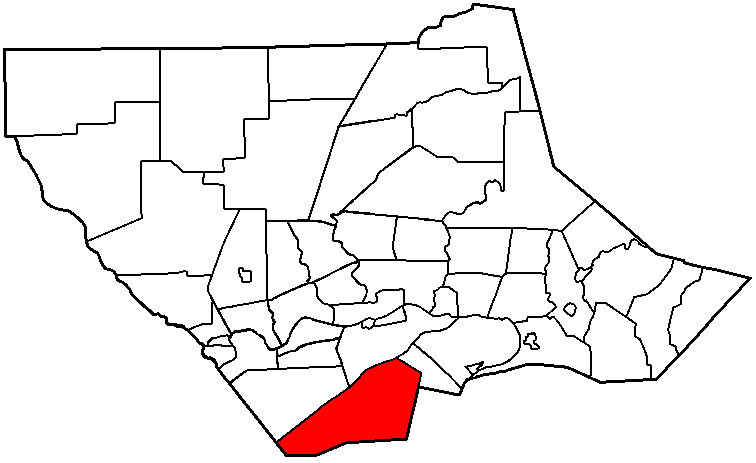
mapsize = 250x200px
map_caption = Map of Lycoming County, Pennsylvania highlighting Washington Township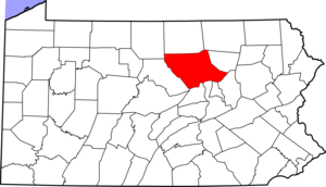
mapsize1 = 250x200px
map_caption1 = Map of Lycoming County, Pennsylvania
subdivision_type = Country
subdivision_name =United States
subdivision_type1 = State
subdivision_name1 =Pennsylvania
subdivision_type2 = County
subdivision_name2 = Lycoming
subdivision_type3 =
subdivision_name3 =
subdivision_type4 =
subdivision_name4 =
government_footnotes =
government_type =
leader_title =
leader_name =
leader_title1 =
leader_name1 =
leader_title2 =
leader_name2 =
leader_title3 =
leader_name3 =
leader_title4 =
leader_name4 =
established_title = Settled
established_date = 1760
established_title2 = Formed
established_date2 = 1786
established_title3 =
established_date3 =
area_magnitude =
unit_pref = Imperial
area_footnotes =
area_total_km2 = 125.8
area_land_km2 = 125.7
area_water_km2 = 0.0
area_total_sq_mi = 48.5
area_land_sq_mi = 48.6
area_water_sq_mi = 0.0
area_water_percent =
area_urban_km2 =
area_urban_sq_mi =
area_metro_km2 =
area_metro_sq_mi =
area_blank1_title =
area_blank1_km2 =
area_blank1_sq_mi =
population_as_of = 2000
population_footnotes =
population_note =
population_total = 1613
population_density_km2 = 12.8
population_density_sq_mi = 33.2
population_metro =
population_density_metro_km2 =
population_density_metro_sq_mi =
population_urban =
population_density_urban_km2 =
population_density_urban_sq_mi =
population_blank1_title =
population_blank1 =
population_density_blank1_km2 =
population_density_blank1_sq_mi =
timezone = Eastern Time Zone (North America)
utc_offset = -5
timezone_DST = EDT
utc_offset_DST = -4
latd = 41 |latm = 7 |lats = 21 |latNS = N
longd = 77 |longm = 2 |longs = 37 |longEW = W
elevation_footnotes =
elevation_m = 441
elevation_ft = 1447
postal_code_type =
postal_code =
area_code =
blank_name = Named for
blank_info =George Washington
blank1_name = GNIS feature ID
blank1_info = 1216775GR|3
website =
footnotes =Washington Township is a township in Lycoming County,
Pennsylvania , in the United States. The population was 1,613 at the 2000 census. It is part of the Williamsport, PennsylvaniaMetropolitan Statistical Area .History
Washington Township was formed as part of Northumberland County in 1786. It originally extended from
White Deer Hole Creek north to theWest Branch Susquehanna River with its eastern boundary also formed by the west branch. The western limit was ambiguous, but most historians assumed that the western boundary followed a line that extended to the south opposite the mouth of Pine Creek in what is now eastern Clinton County. Washington Township is older than Lycoming County. Therefore it was one of the original townships in Lycoming County. Seven additional townships were created from land that was originally part of Washington Township. They are Armstrong, Bastress, Brady, Clinton, Limestone, Nippenose, and Susquehanna Townships.cite book | last = Meginness | first = John Franklin | title = History of Lycoming County, Pennsylvania: including its aboriginal history; the colonial and revolutionary periods; early settlement and subsequent growth; organization and civil administration; the legal and medical professions; internal improvement; past and present history of Williamsport; manufacturing and lumber interests; religious, educational, and social development; geology and agriculture; military record; sketches of boroughs, townships, and villages; portraits and biographies of pioneers and representative citizens, etc. etc."
origdate = 1892
url = http://www.usgennet.org/usa/pa/county/lycoming/history/lyco-history-01.html
accessdate = 2007-04-24
edition = 1st Edition
publisher = Brown, Runk & Co.
location = Chicago, IL
id = ISBN 0-7884-0428-8
chapter = XXXIX
chapterurl = http://www.usgennet.org/usa/pa/county/lycoming/history/Chapter-34.html
quote = (Note: ISBN refers to Heritage Books July 1996 reprint. URL is to a scan of the 1892 version with some OCR typos).] The township is named for the hero of theAmerican Revolution and the 1stPresident of the United States ,George Washington .Historically, two trails of the native indigenous peoples ran along parts of
White Deer Hole Creek in Washington Township. Settlers arrived by 1760, but fled in 1778 during the American Revolutionary War duringThe Big Runaway . They returned and the creek served as the southern boundary of Lycoming County and Washington Township when it was formed in 1795. A logging railroad ran along the creek from 1901 to 1904 for timberclearcutting and small-scale lumbering continues.The
Great Island Path was a major trail that ran north along the Susquehanna River from the Saponi village of Shamokin at modern Sunbury, fording the river there and following the west bank of the West Branch Susquehanna River north until White Deer Hole valley. The path turned west at Allenwood and followed White Deer Hole Creek until about the present location of Elimsport in Washington Township. There it headed northwest, crossed North White Deer Ridge and passed west through the Nippenose valley, then turned north and crossedBald Eagle Mountain via McElhattan Creek and ran along the south bank of the river to the Great Island (near the present day city of Lock Haven).cite book | last = Wallace | first = Paul A.W. | title = Indian Paths of Pennsylvania | edition = Fourth Printing | year = 1987 | publisher = Pennsylvania Historical and Museum Commission | location = Harrisburg,Pennsylvania | id = ISBN 0-89271-090-X | quote = (Note: ISBN refers to 1998 impression.) | pages = pp. 42, 63-64]In the American Revolutionary War, settlements throughout the Susquehanna valley were attacked by Loyalists and Native Americans allied with the British. After the
Wyoming Valley battle and massacre in the summer of 1778 (near what is now Wilkes-Barre) and smaller local attacks, the Big Runaway occurred throughout the West Branch Susquehanna valley. Settlers fled feared and actual attacks by the British and their allies. Settlers abandoned their homes and fields, drove their livestock south, and towed their possessions on rafts on the river to Sunbury. Their abandoned property was burnt by the attackers. Some settlers soon returned, only to flee again in the summer of 1779 in the "Little Runaway".cite book | others = The Lycoming County Unit of the Pennsylvania Writers Project of theWork Projects Administration | title = A Picture of Lycoming County | origdate = 1939 | url = http://www.libraries.psu.edu/do/digitalbookshelf/2799521/ | format = PDF | accessdate = 2006-07-23 | edition = First edition | publisher = The Commissioners of Lycoming County Pennsylvania]Beginning with the first settlers, much of the land along White Deer Hole Creek in Washington Township was slowly cleared of timber. Small sawmills were built in the 19th century, and a much larger lumber operation was run by the Vincent Lumber Company from 1901 to 1904. They built a 3 ft 6 in narrow gauge railroad from Elimsport convert|5|mi|km|0 west into timber, and a line east to Allenwood in Union County and the
Reading Railroad there. The lumber railroad ran parallel to the creek, with the end of the track near the Fourth Gap. It was incorporated onJune 24 ,1901 (around the time of construction) as the "Allenwood and Western Railroad". The lumbering operation ceased in 1904 when the forests were gone. The railroad was torn up, and its one second-handShay locomotive was moved to the Vincent Lumber Company operation at Denholm (in Juniata County).cite book | author=Taber, Thomas T., III | year=1987 | title=Railroads of Pennsylvania Encyclopedia and Atlas | publisher=Thomas T. Taber III | id=ISBN 0-9603398-5-X]From 1900 to 1935, much of what is now
Tiadaghton State Forest was purchased by Pennsylvania from lumber companies that had no further use for the clear-cut land. In the 1930s there were sevenCivilian Conservation Corps camps to construct roads and trails in the forest.cite news | authorlink = Pennsylvania Department of Conservation and Natural Resources | author = Pennsylvania Department of Conservation and Natural Resources | Bureau of Forestry | title = A Public Use Map for Tiadaghton State Forest | format = Map / Brochure | date = November 2004]Small-scale lumbering continues in the Washington Township, but the forest is certified as well-managed "in an environmentally sensitive manner" and lumber from it qualifies for a "green label". A sawmill owned and operated by Amish is on
Pennsylvania Route 44 in Elimsport. It burned down onMay 10 ,2006 (causing $500,000 in damages) but was expected to be back in operation in a month. [cite news | first = Philip A. | last = Holmes | title = Fire claims Route 44 sawmill
url = http://64.233.161.104/search?q=cache:HX09odwgqCEJ:www.sungazette.com/articles.asp%3FarticleID%3D4540+elimsport+amish&hl=en&gl=us&ct=clnk&cd=7 | publisher =Williamsport Sun-Gazette | date =May 13 ,2006
accessdate = 2006-11-20] Despite this small-scale lumbering, as of 2006 the forests have grown back and are mixedoak , withblueberry and mountain laurel bushes. White Deer Hole Creek and its tributaries also have stands of hemlock and thickets ofrhododendron along them.cite news | authorlink = Pennsylvania Department of Conservation and Natural Resources | author = Pennsylvania Department of Conservation and Natural Resources | Bureau of Forestry | title = Central Mountains Shared Use Trails System: Union, Lycoming and Clinton Counties, Bald Eagle and Tiadaghton State Forests | format = Map / Brochure | year = 2002]Geography
Washington Township is bordered by Clinton County to the west, Limestone Township to the northwest, Armstrong Township to the north, Brady Township to the northeast, and Union County to the east and south.
As the crow flies , Lycoming County is about convert|130|mi|km|0 northwest ofPhiladelphia and convert|165|mi|km|0 east-northeast of Pittsburgh.According to the
United States Census Bureau , the township has a total area of 48.5square mile s (125.7km² ), all of it land.Demographics
As of the
census GR|2 of 2000, there were 1,613 people, 549 households, and 462 families residing in the township. Thepopulation density was 33.2 people per square mile (12.8/km²). There were 639 housing units at an average density of 13.2/sq mi (5.1/km²). The racial makeup of the township was 98.57% White, 0.19% African American, 0.37% Native American, 0.12% Asian, 0.12% from other races, and 0.62% from two or more races. Hispanic or Latino of any race were 0.19% of the population.There were 549 households out of which 39.2% had children under the age of 18 living with them, 76.7% were married couples living together, 4.7% had a female householder with no husband present, and 15.8% were non-families. 13.1% of all households were made up of individuals and 6.0% had someone living alone who was 65 years of age or older. The average household size was 2.94 and the average family size was 3.21.
In the township the population was spread out with 28.9% under the age of 18, 7.1% from 18 to 24, 28.5% from 25 to 44, 24.5% from 45 to 64, and 11.1% who were 65 years of age or older. The median age was 36 years. For every 100 females there were 108.4 males. For every 100 females age 18 and over, there were 104.5 males.
The median income for a household in the township was $41,739, and the median income for a family was $45,804. Males had a median income of $31,098 versus $22,031 for females. The
per capita income for the township was $17,124. About 6.5% of families and 10.3% of the population were below thepoverty line , including 17.4% of those under age 18 and 4.0% of those age 65 or over.References

Wikimedia Foundation. 2010.