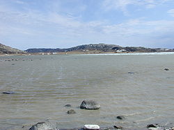
- Umingmaktok
-
Umingmaktok
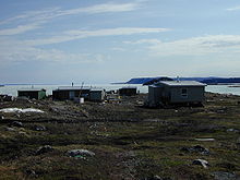
Umingmaktuuq— Settlement — Umingmaktuuq - looking towards the Co-op store Coordinates: 67°41′56″N 107°55′27″W / 67.69889°N 107.92417°WCoordinates: 67°41′56″N 107°55′27″W / 67.69889°N 107.92417°W Country  Canada
Territory  Nunavut
Region Kitikmeot Region Electoral district Cambridge Bay Government[1][2] – n/a n/a – MLA Keith Peterson Area[3] – Total 100.28 km2 (38.7 sq mi) Elevation[4] 0 m (0 ft) Population (2006)[3] – Total 0 – Density 0/km2 (0/sq mi) Time zone MST (UTC-7) – Summer (DST) MDT (UTC-6) Canadian Postal code X0B 2A0 The community of Umingmaktok ("he or she caught a muskox") is located in Bathurst Inlet in the Kitikmeot Region of Canada's Nunavut Territory. The community was previously known as Bay Chimo and the Inuit refer to the community as Umingmaktuuq ("like a musk ox").
The traditional language of the area was Inuinnaqtun and is written using the Latin alphabet rather than the syllabics of the Inuktitut writing system. Like Cambridge Bay, Bathurst Inlet and Kugluktuk syllabics are rarely seen and used mainly by the Government of Nunavut.
Situated at the site of a deserted Hudson's Bay Company post, the community was formed as an outpost camp by Inuit families that wanted to live a more traditional lifestyle. The area around Umingmaktuuq is said to be rich in wildlife such as the Arctic fox, fur seals, barren-ground caribou, Arctic char and musk ox.
As of the 1996 Census, there were 51 people living in Umingmaktuuq, all but one of whom were Inuit. As of the 2006 census the population was 0 as opposed to 5 people in the 2001 census.[3] At present, there are two families residing permanently in the community.
With less than two dozen residents, Umingmaktuuq is one of the smallest permanent non-military communities in Nunavut. At one time the community had a school that provided education up to Grade 6. Today, any students are flown to Cambridge Bay and return to the community only for the summer and Christmas.
The community has no electricity other than that provided by portable generators, and communication with the outside world is by satellite phone. The only access to the community is by chartered aircraft, and the landing strip divides Umingmaktuuq in half. On one side is the old Hudson's Bay Company buildings and the Co-op store. On the other side is the main residential area.
Contents
See also
References
- ^ Hamlets elect new councils
- ^ Election Results - 2008 General Election
- ^ a b c 2006 census
- ^ Elevation at airport. Canada Flight Supplement. Effective 0901Z 20 October 2011 to 0901Z 15 December 2011
- Regional Analysis of the West Kitikmeot
- Nunavut Handbook - Joe Otokiak
- Office of the Languages Commissioner of Nunavut - PDF Dialect Map
- Office of the Languages Commissioner of Nunavut - Writing systems
Further reading
- Lee, John. Wolverine Harvest and Carcass Collection Coppermine, Bay Chimo and Bathurst Inlet, 1992/93. Yellowknife, NWT: Dept. of Renewable Resources, Govt. of Northwest Territories, 1994.
External links
- E-mail in Bay Chimo
- West Kitikmeot Slave Study (map)
- Canadian Arctic Profiles (outdated)
- http://www.nunavuttourism.com/explore/index.aspx?l=0,2,4,6,28
 Subdivisions of Nunavut
Regions Communities Arctic Bay · Arviat · Baker Lake · Bathurst Inlet · Cambridge Bay · Cape Dorset · Chesterfield Inlet · Clyde River · Coral Harbour · Gjoa Haven · Grise Fiord · Hall Beach · Igloolik · Iqaluit Apex · Kimmirut · Kugaaruk · Kugluktuk · Pangnirtung · Pond Inlet · Qikiqtarjuaq · Rankin Inlet · Repulse Bay · Resolute · Sanikiluaq · Taloyoak · Whale CoveWeather stations
and Canadian Forces basesMine sites Proposed Baffinland Iron MineUnder construction Defunct Bent Horn Mine · Cullaton Lake/Shear Lake Mine · Jericho Diamond Mine · Lupin Mine · Nanisivik Mine · Polaris mine · Rankin Inlet MineDEW line and NWS sites Bernard Harbour · Bray Island · Brevoort Island · Broughton Island · Byron Bay · Cambridge Bay · Cape Dyer · Cape Hooper · Cape Mcloughlin · Cape Mercy · Cape Peel West · Cape Young · Clifton Point · Clinton Point · Croker River · Dewar Lakes · Durban Island · Edinburgh Island · Ekalugad · Gjoa Haven · Gladman Point · Hall Beach · Harding River · Hat Island · Jenny Lind Island · Kangok Fjord · Keats Point · Keith Bay · Kivitoo · Lady Franklin Point · Lailor River · Loks Land · Longstaff Bluff · Mackar Inlet · Matheson Point · Nudluardjuk Lake · Pelly Bay · Resolution Island · Ross Point · Rowley Island · Scarpa Lake · Shepherd Bay · Simpson Lake · Sturt PointFormer Amadjuak · Brooman Point Village · Craig Harbour · Dundas Harbour · Iglunga · Killiniq · Native Point · Nuwata · Padlei · Port Leopold · TavaniHudson's Bay Company
trading postsAmadjuak · Apex · Arctic Bay · Baker Lake · Bathurst Inlet · Bay Chimo · Belcher Islands · Blacklead Island · Cambridge Bay · Cape Dorset · Charlton Island Depot · Chesterfield Inlet · Clyde River · Coats Island · Dundas Harbour · Eskimo Point · Fort Hearne · Fort Ross · Frobisher Bay · Gjoa Haven · Igloolik · Kent Peninsula · King William Island · Kugaryuak · Lake Harbour · Mansel Island · Nueltin House · Padley · Pangnirtung · Pangnirtung Fox Farm · Perry River · Ponds Inlet · Port Leopold · Port Burwell · Repulse Bay · Southampton Island · Tavane · Tree River · Wager InletCategories:- Populated places in Arctic Canada
- Populated places in the Kitikmeot Region
Wikimedia Foundation. 2010.


