- Cambridge Bay, Nunavut
Infobox Settlement
official_name = Pagename
other_name = Iqaluktuuttiaq
native_name =
nickname =
settlement_type = Hamlet
motto =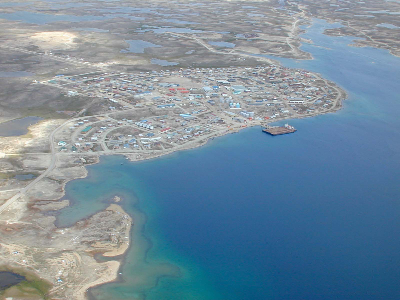
imagesize = 295px
image_caption = Aerial view of Cambridge Bay looking north
flag_size =
image_
seal_size =
image_shield =
shield_size =
city_logo =
citylogo_size =,_Nunavut,_Canada.png)
mapsize = 295px
map_caption = Cambridge Bay, Nunavut, Canada.legend|#ffff66|Nunavutlegend|#ffccff|Northwest Territorieslegend|#d5fe94|Quebec
mapsize1 =
map_caption1 =
image_dot_
dot_mapsize =
dot_map_caption =
dot_x = |dot_y =
pushpin_
pushpin_label_position =
pushpin_map_caption =
pushpin_mapsize =
subdivision_type = Country
subdivision_name = Canada
subdivision_type1 = Territory
subdivision_name1 =Nunavut
subdivision_type2 = Region
subdivision_name2 = Kitikmeot Region
subdivision_type3 =
subdivision_name3 =
subdivision_type4 =
subdivision_name4 =
government_footnotes =
government_type =
leader_title = Mayor
leader_name = Michelle Gillis
leader_title1 = Senior Administrative Officer
leader_name1 = Bill Buckle
leader_title2 =
leader_name2 =
leader_title3 =
leader_name3 =
leader_title4 =
leader_name4 =
established_title = Settled
established_date = 1921
established_title2 = Incorporated (hamlet)
established_date2 =1 April 1984
established_title3 =
established_date3 =
area_magnitude =
unit_pref =
area_footnotes =cite web |url=http://www12.statcan.ca/english/census06/data/profiles/community/Details/Page.cfm?Lang=E&Geo1=CSD&Code1=6208073&Geo2=PR&Code2=62&Data=Count&SearchText=Cambridge&SearchType=Begins&SearchPR=62&B1=All&Custom= |title=2006 Community Profiles |accessdate=2007-06-08 |format= |work= ]
area_total_km2 = 202.20
area_land_km2 =
area_water_km2 =
area_total_sq_mi =
area_land_sq_mi =
area_water_sq_mi =
area_water_percent =
area_urban_km2 = 0.49
area_urban_sq_mi =
area_metro_km2 =
area_metro_sq_mi =
population_as_of = 2006
population_footnotes =
population_note =
population_total = 1477
population_density_km2 = 7.3
population_density_sq_mi =
population_metro =
population_density_metro_km2 =
population_density_metro_sq_mi =
population_urban = 1147
population_density_urban_km2 = 2340.82
population_density_urban_sq_mi =
population_blank1_title =
population_blank1 =
population_density_blank1_km2 =
population_density_blank1_sq_mi =
timezone = Mountain
utc_offset = -7
timezone_DST = MDT
utc_offset_DST = -6
latd=69 |latm=07 |lats=02 |latNS=N
longd=105 |longm=03 |longs=11 |longEW=W
elevation_footnotes = CFS]
elevation_min_m = 0
elevation_max_m = 183
postal_code_type =Canadian Postal code
postal_code = X0B 0C0
area_code = 867
blank_name =Telephone Exchange
blank_info = 983
blank1_name = GNBC Code
blank1_info = CAPHL
blank2_name = NTS Map
blank2_info = 011D12
website = [http://www.cambridgebay.ca/ Official site]
footnotes =Cambridge Bay (
Inuinnaqtun : "Iqaluktuuttiaq"Inuktitut : ᐃᖃᓗᒃᑑᑦᑎᐊᖅ) (2006 population 1,477; UA population 1,147) named forPrince Adolphus, Duke of Cambridge , is a hamlet located in the Kitikmeot Region ofNunavut ,Canada . The traditionalInuinnaqtun name for the area is "Ikaluktuutiak" (oldorthography ) or "Iqaluktuttiaq" (new orthography) meaning "good fishing place"; The 2008 Rand McNally Road Atlas shows a new name of Ikaluktutiak, but the name has not been officially changed.The traditional language of the area was Inuinnaqtun and is written using the
Latin alphabet rather than the syllabics of the Inuktitut writing system. Like Kugluktuk, Bathurst Inlet and Umingmaktok syllabics are rarely seen and used mainly by the Government of Nunavut. [ [http://langcom.nu.ca/languages/dialectmap-web.pdf Office of the Languages Commissioner of Nunavut - PDF Dialect Map] ] [ [http://langcom.nu.ca/languages/en_writing.html Office of the Languages Commissioner of Nunavut - Writing systems] ]Location and population
Located on the south coast of Victoria Island Cambridge Bay is a transportation and administrative center for the western Kitikmeot Region. As of the 2006 census the population was 1,477 an increase of 12.8% from the 2001 census. The population is approximately 80%
Inuit . It is a normal stop for passenger and research vessels traversing theNorthwest Passage .The area was a traditional hunting and fishing location and archeological sites are often found.
Barren-ground Caribou ,Muskox ,Arctic char ,Lake trout andRinged Seal were the primary and remain important food sources today. Situated east of Cambridge Bay is Ovayok Territorial Park.History
Cambridge Bay was the site of
Royal Canadian Mounted Police (RCMP) andHudson's Bay Company outposts established during the 1920s. FollowingWorld War II a LORAN tower was built near the previous location of Cambridge Bay and aDEW Line site established in 1955. Unlike the majority of the DEW Line radar sites which were abandoned or automated, this site, known as CAM-MAIN, remains a manned operation. The military presence and the services and economy this represented acted as a magnet for Inuit who had previously used the area as a temporary site for meeting, hunting, fishing and trade, and a permanent community was soon established.The
Kitikmeot Inuit Association ,Nunavut Impact Review Board , andNunavut Planning Commission have their head offices in Cambridge Bay, as well as the Lands and Resources Department ofNunavut Tunngavik Incorporated .During his campaign for the January 2006 Canadian federal election, Conservative Party leader
Stephen Harper unveiled an Arctic Defence plan which would establish a permanent Arctic training school near Cambridge Bay. [ [http://www.sfu.ca/casr/ft-harper1-5.htm Stephen Harper announces the new defence policy put forward by the Conservative Party of Canada – Pt 5] , "Canadian American Strategic Review ",December 22 ,2005 .] In August 2007, Harper announced that the training base would be inResolute Bay , Nunavut.Cambridge Bay has northern historical significance. It is the final resting place of the "Baymaud" captained by
Roald Amundsen .Media
Radio
In addition to a
community radio station, Cambridge Bay is served by "two"CBC Radio One transmitters, rebroadcasting the stations from bothIqaluit andInuvik, Northwest Territories .* FM 97.7 - CFBI,
community radio
* FM 101.9 - CFFB-1,CBC Radio One
* FM 105.1 - CBIN,CBC Radio One Television
*Channel 9 - CBENT,
CBC North Internet Services
*
QINIQ , Broadband Internet service provider for Nunavut
*Polarnet, Internet Service provider for the Kitikmeot region [ [http://www.polarnet.ca/ Polarnet] ]
*Netkaster, satellite Internet service provided byNorthwestel [ [http://www.netkaster.com/ Netkaster] ]Climate
Infobox Weather
metric_first= Yes
location =Cambridge Bay Airport
Year_Hi_°F = 6.08
Jan_Hi_°C = -29.3
Feb_Hi_°C = -29.3
Mar_Hi_°C = -25.7
Apr_Hi_°C = -16.7
May_Hi_°C = -5.3
Jun_Hi_°C = 5.6
Jul_Hi_°C = 12.3
Aug_Hi_°C = 9.4
Sep_Hi_°C = 1.9
Oct_Hi_°C = -8.1
Nov_Hi_°C = -19.3
Dec_Hi_°C = -26.1
Year_Hi_°C = -10.9
Jan_Lo_°C = -36.3
Feb_Lo_°C = -36.6
Mar_Lo_°C = -33.7
Apr_Lo_°C = -26
May_Lo_°C = -13
Jun_Lo_°C = -0.8
Jul_Lo_°C = 4.6
Aug_Lo_°C = 3.4
Sep_Lo_°C = -2.5
Oct_Lo_°C = -14.9
Nov_Lo_°C = -26.5
Dec_Lo_°C = -33
Year_Lo_°C = -18
Jan_Precip_mm = 4.6
Feb_Precip_mm = 5.1
Mar_Precip_mm = 6
Apr_Precip_mm = 6.5
May_Precip_mm = 9.4
Jun_Precip_mm = 12.5
Jul_Precip_mm = 21.7
Aug_Precip_mm = 26.7
Sep_Precip_mm = 19.3
Oct_Precip_mm = 14.6
Nov_Precip_mm = 7.2
Dec_Precip_mm = 5.3
Year_Precip_mm = 138.8
source= Enviroment Canada [ [http://www.climate.weatheroffice.ec.gc.ca/climate_normals/results_e.html?Province=NU%20%20&StationName=&SearchType=&LocateBy=Province&Proximity=25&ProximityFrom=City&StationNumber=&IDType=MSC&CityName=&ParkName=&LatitudeDegrees=&LatitudeMinutes=&LongitudeDegrees=&LongitudeMinutes=&NormalsClass=A&SelNormals=&StnId=1786& Canadian Climate Normals 1971-2000] ]
accessdate= August 2008See also
*
Cambridge Bay Airport
*Cambridge Bay Water Aerodrome References
Further reading
* 2007. "Mosaic - Snow Sprints in Cambridge Bay, Nunavut - Photography by Finn O'Hara". "Canadian Geographic". 127, no. 2: 100.
* Barlishen, W. J., and T. N. Webber. "A History of the Development of Commercial Fishing in the Cambridge Bay Area of the Northwest Territories". 1973.
* Canada. "Cambridge Bay". Ottawa: Environment Canada, Atmospheric Environment Service, 1984. ISBN 066052564X
* Canada Centre for Mineral and Energy Technology, and Resource Ventures Incorporated. "Cambridge Bay Wind Farm". [Ottawa] : The Branch, 1997.
* Gajda, Roman. "Terrain and Site Analysis of Cambridge Bay, N.W.T". Ottawa: Dept. of Mines and Technical Surveys, Geographical Branch, 1962.
* Hill, Steven Grant. "Ethnography of Inuit Elderly in a Present Day Arctic Settlement, Cambridge Bay, N.W.T". Ottawa: National Library of Canada, 1990. ISBN 0315515651External links
* [http://www.cambridgebay.ca/ Official site]
* [http://www.walrusmagazine.com/articles/2007.11-growing-up-arctic/ Images of Cambridge Bay Youth]
Wikimedia Foundation. 2010.