- Nahal Alexander
-
Alexander
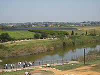
Alexander streamLength 28 miles (45 km) Nahal Alexander (נחל אלכסנדר) is a river that flows from the mountains of Samaria to the Mediterranean Sea, north of Netanya. The length of the river is about 45 km.
Several small streams flow into Nahal Alexander: Nablus, Te'enim, Ometz, Bahan, and Avihail. Most of the river is located in the Hefer Valley.
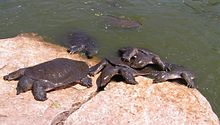
Nahal Alexander is the habitat of soft-shell turtles that can reach a size of 1.20 meters and weigh up to 50 kilograms. In addition to giant turtles, there are coots and other waterfowl, nutrias and swamp cats. Indigenous fish include catfish, tilapia, river eels and mullet.[1]
On the southern bank there are shifting sand dunes and on the northern bank, an eucalyptus grove. On a hill nearby is Hurvat Samra, an ancient ruin that may have been a customs station for goods transported down the river to the port near the estuary.[2]
In the spring, the hill blooms with anemones, buttercups, and tulips. Beit Yanai beach is located where the river flows into the Mediterranean.[3] North of the beach are remnants of a quay built in 1938, during the British Mandate. It was used for clandestine Jewish immigration to Palestine when British authorities turned away ships of European Jews fleeing the Nazis.[4]
Nahal Alexander was named after Hasmonean king of Judaea Alexander Jannaeus.[citation needed]
See also
References
National parks of Israel Jerusalem District Bayt 'Itab · Canada Park · Castel · City of David National Park1 · Ein Hemed · Judaean Mountains · Tomb of Samuel1North District Achziv · Bar'am National Park · Beit Alfa Synagogue · Beit She'an · Beit She'arim · Belvoir Fortress · Capernaum · Chorazin · Gan HaShlosha · Hamat Gader · Hamat Tiberias · Harod Spring · Hermon National Park1 · Hexagons pool · Horns of Hattin · Hurshat Tal · Hurvat Minia · Kursi1 · Montfort Castle · Mount Arbel · Mount Tabor · Nimrod Fortress1 · Rosh HaNikra · Sde Amudim · Sussita · Tel Hazor · Tel Kedesh · Tel Megiddo · Tzalmon Stream · Tzippori · Yehi'am Fortress · Hula ValleyHaifa District Central District Alexander stream · Arsuf · Hof HaSharon · Mazor Mausoleum · Migdal Afek · Palmachim beach · Rubin Stream · Sidna Ali · Tel Afek · Tel Gezer · Tzur Natan park · Yarkon National ParkSouthern District Ashkelon National Park · Avdat · Besor Stream · Beit Guvrin National Park · Ein Avdat · Ein Gedi · Eshkol Park · Mamshit · Masada · Monument to the Negev Brigade · Nitzana · Semekh caves · Shivta · Tel Arad · Tel Be'er Sheva · Tel Lachish · Tel ZafitJudea and Samaria Area 1 Located in the Israeli-occupied territories
Coordinates: 32°23′46.08″N 34°51′56.53″E / 32.3961333°N 34.8657028°ECategories:- National parks of Israel
- Rivers of Israel
Wikimedia Foundation. 2010.


