- Drew Park
-
Drew Park — Neighborhood — Location within the state of Florida
 Drew Park
Coordinates: 27°59′7″N 82°30′54″W / 27.98528°N 82.515°WCoordinates: 27°59′7″N 82°30′54″W / 27.98528°N 82.515°W Country United States State Florida County Hillsborough City Tampa Population (2000) - Total 1,129 Time zone Eastern (EST) (UTC-5) - Summer (DST) EDT (UTC-4) ZIP codes 33607 and 33614 FIPS code GNIS feature ID Drew Park is a neighborhood within the city limits of Tampa, Florida. As of the 2000 census the neighborhood had a population of 1,129. The ZIP Codes serving the neighborhood are 33607 and 33614.
Contents
Geography
Drew Park boundaries are Hillsborough Avenue to the north, Tampa Bay Blvd. to the south, Tampa International Airport to the west, and Dale Mabry Highway to the east.[1] The area is flat but above any flood zones.
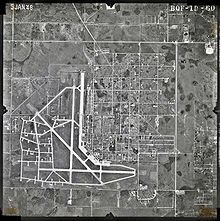 Drew Field in 1948
Description
Drew Park was originally Drew Field, named for cattleman and land developer John H. Drew. It was Tampa's first municipal airport, a 130-acre (0.53 km2) grass airfield that opened in 1928. At the onset of World War II, the federal government took over the field and developed a military base containing airstrips, barracks, field hospitals, and a German and Italian POW camp. The City of Tampa leased the field to the army for one dollar a year. Parts of the film Air Force were filmed here. The base theater is still standing today as the Playhouse Adult Theater. Dale Mabry Highway was built in 1943 to link Drew Field with MacDill Air Force Base to the south.
Drew Park is now home to the main campus of the Hillsborough Community College, George Steinbrenner Field and (before it was demolished) the former W. T. Edwards Tuberculosis Hospital. Auto dealerships populate much of the Dale Mabry edge of Drew Park and shopping and restaurants make up the Hillsborough Ave edge. The core of Drew Park is occupied by light industry, adult entertainment establishments and several homes, due to its mixed-use zoning. Law enforcement has conducted many raids on the businesses in the area accusing them of prostitution, operating without licenses, and illegally selling alcohol.
In 1988, Hillsborough County Aviation Authority announced long-term plans to acquire several hundred acres in Drew Park for the expansion of Tampa International. This will include the redevelopment of the Airport's air cargo facility, aircraft maintenance, fuel farms, equipment maintenance, Aircraft Rescue Fire Training facilities and other aviation-related facilities. To date, the authority has acquired 96% of the parcels in the land acquisition area.
Durex Industrial
On June 13, 1992, two nine-year-old boys, Scotty Perez and Anthony Storman, died after climbing into an open dumpster containing toxic chemicals. The dumpster was used by Durex Industrial, Inc. at 4815 N West Shore Blvd. to illegally dispose of toluene which was used in the manufacturing of printing rollers. Two employees, William C. Whitman and Duane C. Whitman, were sentenced to 27-month prison sentences for illegally handling, storing or disposing of toluene. Durex Industries was fined $1.5-million. A Hillsborough county jury awarded the families a $500-million verdict against the company. The corporation itself was broke and no money was paid to the families. In 1998, the owner William Recht Jr. agreed to pay each family $400,000 and a $200,000 fine after pleading guilty to storing hazardous wastes without a permit. He was sentenced to 30 months of probation.
The incident caused many businesses in the area to install locks on their dumpsters. It later inspired the play The Toxic Wave by Susan Hussey, co-founder of the Drew Park-based Gorilla Theatre.
Demographics
Source: Hillsborough County Atlas
As of the census[2] of 2000, there were 1,129 people and 338 households residing in the neighborhood. The population density was 873/mi². The racial makeup of the neighborhood was 35% White, 16% African American, 1% Native American, 5% Asian, and 5% from two or more races. Hispanic or Latino of any race were 38% of the population.
There were 338 households out of which 25% had children under the age of 18 living with them, 38% were married couples living together, 8% had a female householder with no husband present, and 9% were non-families. 38% of all households were made up of individuals.
In the neighborhood the population was spread out with 19% under the age of 18, 33% from 18 to 34, 31% from 35 to 49, 7% from 50 to 64, and 9% who were 65 years of age or older. For every 100 females there were 150.1 males.
The per capita income for the neighborhood was $9,887. About 26% of the population were below the poverty line, 19% of those under age 18 and 12% of those age 65 or over.
References
- ^ Hillsborough Community Atlas
- ^ "American FactFinder". United States Census Bureau. http://factfinder.census.gov. Retrieved 2008-01-31.
- Drew Park neighbors struggle in transition St. Petersburg Times
- Raid on adult video store leads to 14 arrests St. Petersburg Times
- Raids on businesses result in 36 arrests St. Petersburg Times
- de Quesada, Alejandro M. (1997). World War II in Tampa Bay. Arcadia Publishing. ISBN 0-7524-0888-7.
- Durex plant owner sorry about deaths St. Petersburg Times
- Tampa Airport Drew Park page
See also
External links
- Drew Park Alliance
- Drew Field Echoes, military newspaper for 1942-1945 when Drew Park was a military air field
Regions North Tampa | South Tampa | New Tampa
Historic Districts Hampton Terrace | Hyde Park | Seminole Heights | Tampa Heights | West Tampa | Ybor City
Central Business Districts Downtown Tampa | Uptown Tampa |
Westshore Business DistrictResidential Neighborhoods Armenia Gardens Estates | Audubon Park | Ballast Point | Bayshore Beautiful | Bayshore Gardens | Bayside West | Beach Park | Beach Park Isles | Beasley | Bel Mar Shores | Belmont Heights | Bowman Heights | Bon Air | Carver City-Lincoln Gardens | Channel District | College Hill | Courier City-Oscawana | Cory Lake Isles | Culbreath Bayou | Culbreath Isles | Davis Islands | Dixie Farms | Drew Park | Eastern Heights | East Tampa | East Ybor | Fair Oaks-Manhattan Manor | Fern Cliff | Florence Villa | Forest Hills | Gandy-Sun Bay South | Golf View | Grant Park | Gray Gables | Harbour Island | Harvey Heights | Highland Pines | Historic Hyde Park North | Hunters Green | Interbay | Jackson Heights | Live Oaks Square | Lowry Park | Lowry Park North | MacDill Air Force Base | Macfarlane Park | Marina Club | Maryland Manor | New Suburb Beautiful | North Bon Air | Northeast Community | Northeast Macfarlane | North Hyde Park | North Tampa | Northview Hills | Oakford Park | Oak Park | Old Seminole Heights | Old West Tampa | Palma Ceia | Palma Ceia West | Palmetto Beach | Parkland Estates | Port Tampa | Rattlesnake | Rembrandt Gardens | Ridgewood Park | Riverbend | Rivercrest | River Grove | Riverside Heights | Robles Park | South Seminole Heights | Southeast Seminole Heights | Southern Pines | South Nebraska | South Westshore | Stoney Point | Sulphur Springs | Sunset Park | Swann Estates | Tampa Overlook | Tampa Palms | Temple Crest | Terrace Park | University Square | V.M. Ybor | Virginia Park | Wellswood | West Meadows | Westshore Palms | West Hyde Park | West Riverfront | West Tampa | Woodland Terrace
Industrial areas Garrison Channel | Gary | Uceta Yard
Other areas Rocky Point | Soho District
Categories:


Wikimedia Foundation. 2010.