- Devil's Slide (California)
-
For other places with the same name, see Devil's Slide (disambiguation).
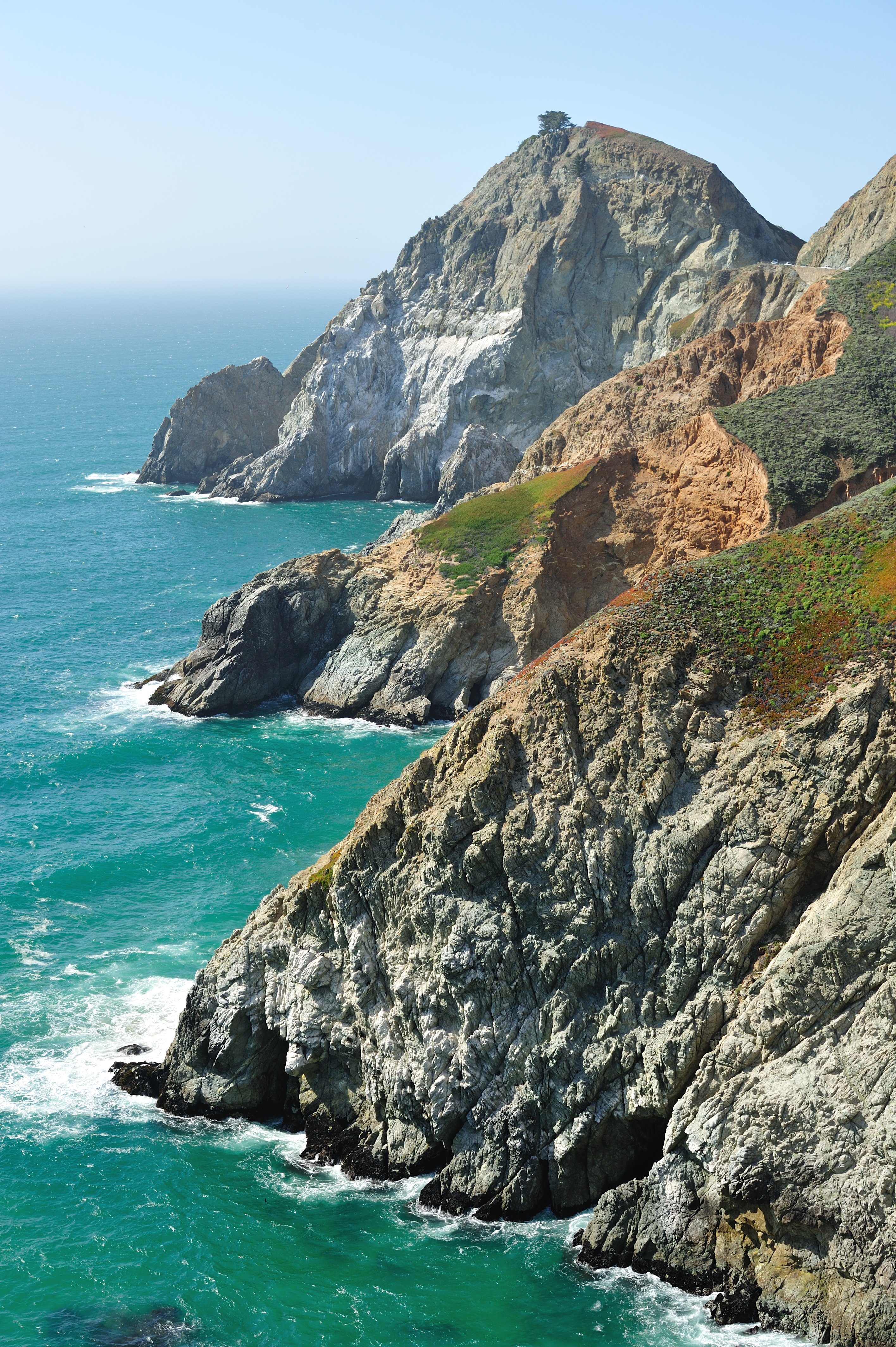
 The sheer cliffs of the Devil's Slide promontory.
Devil's Slide is a coastal promontory in California. It lies on the San Mateo County coast between Pacifica and Half Moon Bay at 37°34′28″N 122°31′13″W / 37.5743825°N 122.5202553°WCoordinates: 37°34′28″N 122°31′13″W / 37.5743825°N 122.5202553°W.
Contents
Natural setting
Devil's Slide is a name given to a steep, rocky coastal promontory located about midway between Montara and the Linda Mar District of Pacifica. The terrain is characterized by steep, eroded slopes with natural gradients ranging between 30 and 70%. There are small coastal valleys throughout along the major drainages within the Montara Mountain watershed. The soils in these valleys are deep and moderately well drained and have developed along the low terraces and alluvial fans of the stream channels.
The climate of the project area is Mediterranean with a strong maritime influence. The temperature range is narrow both seasonally and diurnally, while air moisture is relatively high. Extremely dense northern coastal scrub covers most of the locale, especially over San Pedro Mountain and along the steeper foot slopes of Montara Mountain. Small grassy openings and barren rocky areas are scattered throughout the scrub areas. The inland area holds other types of vegetation including, aquatic and coastal freshwater marshes/seeps, willow riparian scrub, coastal grassland, non-native forest, and pasture/ranch uses/non-native brushland. The endangered species Hickman's potentilla occurs on the slopes above Martini Creek at up to 430 feet (130 m) elevation.
State Route 1
 The construction of the bridge to the tunnel, which would go through Devil's Slide
Immediately north of Devil's Slide is a stretch of California's State Route 1, famous for closures and landslides, which also is called "Devil's Slide". Construction of the road began in 1935 and was completed in 1937, replacing the steep, narrow, and winding Pedro Mountain Road. It is known for the landslides and erosion that often occur during winter storms, sometimes making the road impassable. The first major landslide destroyed much of the road in 1940, and a cycle of building and destruction has prevailed since.
Film
The Devil's Slide was used in a key scene of the 1960 thriller Portrait in Black with Lana Turner and Anthony Quinn. Turner and Quinn portrayed doomed lovers who deliberately pushed a car, containing the body of a murdered man, over the edge of the cliff. The Universal crew obtained permission from the State of California to stage the scene, which involved retrieving the car from the bottom of the cliff once the scene had been successfully filmed. The San Mateo Times printed a photograph of the filming of this sequence.[1]
Military History
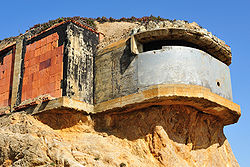 An exposed base end station at Devil's Slide.
Devil's Slide was the location of a military triangulation station and observation site used during World War II as part of the harbor defense of San Francisco.[2] Prior to the advent of radar, military personnel would use binoculars and compasses to search for ships at sea and relay their coordinates to a central post. By combining information from multiple observation posts, a ship's precise location could be determined by triangulation. There were six military structures at the Devil's Slide: three concrete and steel observation pill-boxes, two concrete and earth bunkers, and a reinforced steel observation tower. The pill-boxes were used as hardened observation posts, and one of the bunkers was used as a communications and command post. The site was sold to a private owner in 1983, but some of the structures remain.
History of the highway rebuilding conflict
A bypass was proposed to be constructed to replace the 600-foot-long (180 m) stretch of highway. Beginning in 1958, California began the process to replace Devil's Slide with an inland route over Montara Mountain, known as the Martini Creek Bypass. The bypass bisected a section of McNee Ranch State Park, and was opposed by community and environmental groups. By 1975, 55% of the right-of-way had been acquired, when work on the proposed bypass was abandoned due to public opposition.
Most environmentalists supported a tunnel as a more environmentally sensitive alternative to the Martini Creek Bypass. A short tunnel built in 1908 by the Ocean Shore Railroad went through the area, but was destroyed during Prohibition, to keep it from being used by alcohol smugglers. The Sierra Club proposed building a tunnel to bypass the road in 1973. A Caltrans study in 1974 determined that a tunnel would be a viable alternative to the current road or a proposed inland freeway bypass. However, the state dropped the idea in the late 1970s.
A major slide in 1983 brought the problem to the public attention again. In 1985 Caltrans proposed the Martini Creek bypass as the preferred solution. However, the Sierra Club sued to stop construction, as California law requires that State Route 1 be restricted to two lanes in rural areas. The 101-foot-wide (31 m) road bed, complete with continuous uphill passing lanes, runaway truck ramps, and extra-wide shoulders, would be the widest two-lane road in the state. Again the state decided to return to the status quo.
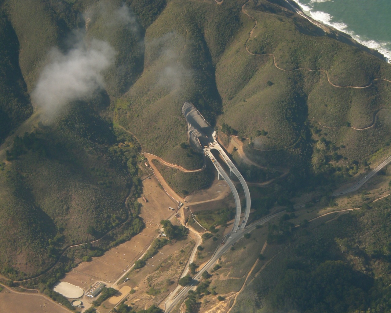
 Aerial view of tunnel under construction as a bypass at Devil's Slide
A five-month outage caused by a slide in January 1995 again brought public scrutiny to the stretch of highway. In April, Caltrans documents were discovered that showed the agency had intentionally overestimated the costs of a tunnel, to support the freeway bypass. In July, the Federal Highway Administration ordered Caltrans to re-evaluate a tunnel to bypass Devil's Slide. On November 5, 1996, San Mateo County voters approved Measure T by 76%, changing the county's stated preference from construction of the bypass to construction of a tunnel. On November 9, Caltrans changed its position, supporting a bridge and tunnel as the best environmental, economic, and popular alternative to Devil's Slide.
Ground was broken for the new tunnel on May 6, 2005. Boring of twin 30-foot (9 m) diameter tunnels started September 17, 2007, and was completed in 2011.[3] Breakthrough on the northern bore occurred on September 30, 2010.[4] After the Devil's Slide tunnel is completed in the fall of 2012, the old Devil's Slide highway will be converted into a trail for hikers and bicyclists.[5]
The Devil's Slide tunnel will become the second longest road tunnel in California at 4,149 feet northbound, and 4,008 feet southbound.[6] By comparison the longest road tunnel currently in California, the Wawona Tunnel on Highway 41 in Yosemite National Park, is 4,233 feet long. The longest road tunnel in the San Francisco Bay Area as of October 2011 at 3,771 feet long is the westbound bore of the Caldecott Tunnel, which links the major central Contra Costa County communities of Concord and Walnut Creek with Oakland and the Bay Bridge on the western side.
2006 storm damage
The Slide was closed on April 2, 2006 at 6:55 p.m. due to cracks in the road, reminiscent of the 1995 failure. Longitudinal cracks along the length of the roadway in both lanes show a slow slippage of the roadbed towards the ocean. The road had already sunk considerably towards the ocean by that time. Extensive work needs to be done to stabilize the slide again, but Caltrans reopened the road during peak hours beginning on August 4, 2006 and reopened it fully in September.
 Devil's Slide in 1995
See also
- Coastal erosion
- California landslides
- Landslides
- California
Bibliography
- Biological Assessment, Species of Concern, Proposed Route 1 Devil's Slide Tunnel Bypass Project, San Mateo County, California Prepared by; Caltrans, Office of Environmental Planning, South. July, 1998.
- Michael Hogan and Ballard George, Air Quality and Noise Analyses for the Bypass Alternative, Devil's Slide Improvement Project, Caltrans District 4, prepared by Earth Metrics Inc., Burlingame, CA (1984)
- Devil's Slide Improvement Project, San Mateo County, California, Draft Second Supplemental Environmental Impact Statement, Caltrans District 4 (1999)
- Hovland, John H., Ph.D., P.E., A Study of the Feasibility of Stabilizing the Landslide Area Along Highway One, San Mateo County, California, by Dewatering, April, 1998
- Woodward-Clyde Consultants, Devil’s Slide Tunnel Study - Feasibility Report, October, 1996.
Footnotes
- ^ American Movie Classics, San Mateo Times
- ^ http://www.corpsfuds.org/reports/INPR/J09CA0789inpr.pdf
- ^ http://articles.sfgate.com/2011-08-05/bay-area/29853515_1_tunneling-crews-san-pedro-mountain-tunnel-work
- ^ http://www.hmbreview.com/articles/2010/09/30/news/breaking_news/doc4ca4ce0671ef9926663919.txt
- ^ http://sfgate.com/cgi-bin/article.cgi?file=/c/a/2005/05/06/BAGC8CL3OQ1.DTL
- ^ http://www.dot.ca.gov/dist4/dslide/dsfaq.htm
External links
Categories:- Buildings and structures in San Mateo County, California
- Landforms of San Mateo County, California
- Pacifica, California
- Roads in California
- Transportation in San Mateo County, California
- Tunnels in the San Francisco Bay Area
- San Francisco Bay Area beaches
- Coastal erosion in the United States of America
- California State Route 1


Wikimedia Foundation. 2010.