- Pilot Knob (Iron County, Missouri)
-
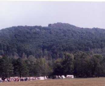
Pilot Knob 
Pilot Knob. Note distinctive summit formation. (1998)Elevation 1,470 ft (448 m) [1] Location Location Iron County, Missouri, USA Range Saint Francois Mountains Coordinates 37°37′10″N 90°37′33″W / 37.6194946°N 90.625956°WCoordinates: 37°37′10″N 90°37′33″W / 37.6194946°N 90.625956°W[1] Topo map USGS Lake Killarney Pilot Knob is located in the Arcadia Valley of Iron County, Missouri between the towns of Ironton, Missouri and Pilot Knob, Missouri. Pilot Knob, so named because of its distinctive shape, reaches an elevation of 1,470 feet (450 m)[2] rising 581 feet (177 m)[3] above the Arcadia Valley floor and has a large deposit of iron ore in its upper regions. Pilot Knob in one peak in the St. Francois Mountain Range, reportedly the oldest mountain range in North America. The mountain was heavily mined in the 19th century, leaving many open mine shafts. The summit of the mountain consists of the 90-acre (36 ha) Pilot Knob National Wildlife Refuge[4] which is the home for nearly 1/3 of the world's population of Indiana Bats. The bats hibernate in the abandoned mine shafts.
Pilot Knob Ore Company donated the land, after ceasing its mining operations, on July 22, 1987, for conservation purposes. Currently the Pilot Knob National Wildlife Refuge is closed to the public and there is an eight-foot-tall (2.44 meters) chain link fence around 40 acres (16 ha) of the land for safety reasons, keeping individuals away from the open mine shafts.
Contents
History
Based on notes and writings of three individuals who traveled with a band of Spanish Conquistadors and explorers, the first Europeans to see the Arcadia Valley and Pilot Knob would have been Hernando DeSoto and his army as it crossed Missouri in September of 1541. Specifically, the date being September 7. They reportedly crossed some mountains and came into the region where Ironton is now located. There they found a good salt spring for making of salt cakes. The next day the army's stragglers caught up to the main body where Pilot Knob is now located. The following day de Soto's band departed the area, moving towards present day Lesterville.[5]
By 1800 members of the Algonquian peoples of Native Americans (Indians) had moved into the area with a village of the Delaware Tribe established at the base of Pilot Knob. This village existed as late as 1819.[6] In the late 1830s during the infamous forced relocation march named the Trail of Tears the Cherokee Tribe came through the valley.[6]
The completion of the Iron Mountain Railroad all the way to the town of Pilot Knob in 1857 provided easy the transportation of iron ore mined from the Pilot Knob to the growing St. Louis. During the Civil War, with a looming invasion of Missouri by the Confederate Army under the command of General Sterling Price, the Union constructed and manned Ft. Davidson, an earth work fortification near the base of Pilot Knob in the small town of Pilot Knob. In September 1864 the invasion materialized and the Battle of Fort Davidson (also called The Battle of Pilot Knob) was fought in the valley below Pilot Knob.
During the years before Pilot Knob was closed to the public, one could hike to the top and experience a blast of cool air flowing out of one of the mine shafts nicknamed the "Devil's Icebox."[7][8] In the early 20th century Easter Sunrise services were held, at sun rise, on the top of Pilot Knob.
Notes
- ^ a b "Pilot Knob". Geographic Names Information System, U.S. Geological Survey. http://geonames.usgs.gov/pls/gnispublic/f?p=gnispq:3:::NO::P3_FID:751593.
- ^ "SummitPost.org : Saint Francois Mountains (MO)". http://www.summitpost.org/area/range/171852/st-francois-mountains-mo.html.
- ^ Conard, Howard Louis (1901). Encyclopedia of the history of Missouri: a compendium of history and biography for ready reference. 5. The Southern history company, Haldeman, Conard & co., proprietors. p. 140. OCLC 32872107. http://books.google.com/books?id=_2wUAAAAYAAJ&pg=PA140.
- ^ "US Fish & Wildlife Service: Pilot Knob National Wildlife Refuge". http://www.fws.gov/refuges/profiles/index.cfm?id=33542.
- ^ "DeSoto's Missouri Trails". http://www.floridahistory.com/missouri.html.
- ^ a b "History of Iron County, Missouri". http://www.rootsweb.ancestry.com/~moicgs/countyhistory.html.
- ^ Reader's Digest 131: 61. 1987.
- ^ "Missouri Historic Towns: Ironton, Lesterville, Pilot Knob (Photo showing the Devil's Icebox". http://missouri-vacations.com/missouri-historic-towns/ironton-lesterville-pilot-knob.htm.
References
- "Pilot Knob Wildlife Refuge, U.S. Fish and Wildlife Service". http://www.fws.gov/refuges/profiles/index.cfm?id=33542. Retrieved April 16, 2009.
- "Summit Post.org (location)". http://www.topozone.com/map.asp?lat=37.61889&lon=-90.62472. Retrieved April 17, 2009.
- "Summit Post.org (elivation)". http://www.summitpost.org/area/range/171852/st-francois-mountains-mo.html. Retrieved April 17, 2009.
- "The DeSoto Chronicles". http://www.floridahistory.com/inset44.html. Retrieved April 20, 2009.
- "DeSoto's Missouri Trails". http://www.floridahistory.com/missouri.html. Retrieved April 20, 2009.
- Encyclopedia of the History of Missouri (1901). http://books.google.com/books?id=_2wUAAAAYAAJ&pg=PA140&lpg=PA140&dq=Pilot+Knob+Mountain,+Missouri&source=bl&ots=5xLmUhHMKz&sig=eKyJtFFNqOqVJ5FlrgXambp9m8c&hl=en&ei=_K_oSfPiNMTktgflvtGSBg&sa=X&oi=book_result&ct=result&resnum=10. Retrieved April 17, 2009.
- "History of Iron County". http://www.rootsweb.ancestry.com/~moicgs/countyhistory.html. Retrieved April 17, 2009.
- Readers Digest,(1987) v. 131, nos. 783-787, page 61. Mention of Devils Icebox
External links
- "Historic Missouri Towns". http://missouri-vacations.com/missouri-historic-towns/ironton-lesterville-pilot-knob.htm. Retrieved April 16, 2009.
- "Photo of Glade at the summit of Pilot Knob". http://bp3.blogger.com/_r7fyo_74HxY/SEFrn3Lh0QI/AAAAAAAAAeM/SJuqCjQCeU0/s1600-h/PilotKnobSummitOutcrop1small.jpg. Retrieved April 17, 2009.
- "Historical Photographs & Postcards of Iron County, Missouri 1". http://www.rootsweb.ancestry.com/~moicgs/photos1.html. Retrieved April 17, 2009.
- "Historical Photographs & Postcards of Iron County, Missouri 7". http://www.rootsweb.ancestry.com/~moicgs/photos7.html. Retrieved April 17, 2009.
- "Ft. Davidson Historic Site (Official Web Site)". http://www.mostateparks.com/ftdavidson.htm. Retrieved April 17, 2009.
Protected Areas of Missouri Federal National Wildlife Refuges:Big Muddy • Clarence Cannon • Great River • Middle Mississippi River • Mingo • Ozark Cavefish • Pilot Knob • Squaw Creek • Swan Lake • Two RiversNational Forests:State Babler • Sam A. Baker • Bennett Spring • Big Lake • Big Oak Tree • Big Sugar Creek • Castlewood • Crowder • Cuivre River • Current River • Elephant Rocks • Finger Lakes • Graham Cave • Grand Gulf • Ha Ha Tonka • Harry S Truman • Hawn • Johnson's Shut-Ins • Jones-Confluence Point • Katy Trail • Knob Noster • Lake of the Ozarks • Lake Wappapello • Lewis and Clark • Long Branch • Mark Twain • Meramec • Montauk • Morris • Onondaga Cave • Pershing • Pomme de Terre • Prairie • Roaring River • Robertville • Rock Bridge Memorial • Route 66 • St. Francois • St. Joe • Stockton • Table Rock • Taum Sauk Mountain • Thousand Hills • Trail of Tears • Van Meter • Wakonda • Wallace • Washington • Watkins Woolen Mill • Weston BendArrow Rock • Battle of Athens • Battle of Carthage • Battle of Lexington • Thomas Hart Benton Home and Studio • Bollinger Mill • Nathan Boone Homestead • Boone's Lick • Bothwell Lodge • Clark's Hill/Norton • Confederate Memorial • Deutschheim • Dillard Mill • Gov. Daniel Dunklin's Grave • Felix Vallé House • First Missouri State Capitol • Fort Davidson • Gen. John J. Pershing Boyhood Home • Harry S Truman Birthplace • Hunter-Dawson • Iliniwek Village • Jefferson Landing • Jewell Cemetery • Locust Creek Covered Bridge • Mark Twain Birthplace • Mastodon • Missouri Mines • Missouri State Capitol • Missouri State Museum • Osage Village • Sandy Creek Covered Bridge • Sappington Cemetery • Scott Joplin House • Towosahgy • Union Covered Bridge • Watkins Woolen MillConservation areas:List of Missouri conservation areasCategories:- Mountains of Missouri
- St. Francois Mountains
- Geography of Iron County, Missouri
- Mountain ranges of Missouri
- National Wildlife Refuges in Missouri
- Regions of Missouri
- Protected areas established in 1987
Wikimedia Foundation. 2010.