- Mark Twain National Forest
-
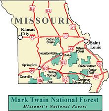 Map of the National Forest
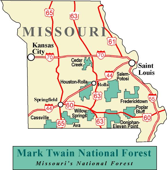
Mark Twain National Forest (MTNF) is a U.S. National Forest located in the southern half of Missouri. MTNF was established on September 11, 1939. It is named for author Mark Twain, a Missouri native. The MTNF covers approximately 1.5 million acres (6,100 km²), 78,000 acres (320 km²) of which are Wilderness, and National Scenic River area. MTNF spans 29 counties and represents 11% of all forested land in Missouri. MTNF is divided into six distinct ranger districts: Ava-Cassville-Willow Springs, Eleven Point, Houston-Rolla-Cedar Creek, Poplar Bluff, Potosi-Fredericktown, and the Salem. The six ranger districts actually comprise nine overall unique tracts of forests. Its headquarters are in Rolla, Missouri.
Some unique features of the Mark Twain include Greer Spring, which is the largest spring on National Forest land, pumping an average of 214 million gallons of water per day.[1] The public can also visit the Glade Top Trail National Scenic Byway, which offers views of over 30 miles (48 km) to the Boston Mountains in Arkansas.
Contents
History
In the 1870s, citizens of southern Missouri began an era of extensive logging of the state's native oak, hickory, and pine forests. Lumber mills were commonplace, but by the 1920s they had disappeared, along with much of the state's native forests. Thus, in 1939 President Franklin D. Roosevelt signed the MTNF into existence. In March 1933, he also created the Emergency Conservation Work Act, better known as the Civilian Conservation Corps (CCC). In the area that would later become Mark Twain National Forest, hundreds of young men at over fifty CCC sites worked at building roads and planting hundreds of acres of pine to preserve and enhance the natural resources of southern Missouri. Many of their contributions can still be visited and enjoyed today.
Wilderness areas
Counties
Although it is far from being the largest National Forest in acreage, Mark Twain National Forest is located in more counties than any other. As of September 30, 2007, its 1,490,862 acres (2,329.47 sq mi, or 6,033.3 km²) were spread over parts of 29 counties in southern and central Missouri.[2]
County Area Acres Hectares Oregon County 104,721 42,379 Ripley County 97,437 39,431 Iron County 96,047 38,869 Carter County 90,641 36,681 Reynolds County 89,933 36,395 Wayne County 88,372 35,763 Shannon County 83,934 33,967 Washington County 82,133 33,238 Dent County 73,011 29,547 Taney County 65,953 26,690 Phelps County 65,379 26,458 Barry County 55,187 22,333 Christian County 52,260 21,149 Madison County 51,170 20,708 Howell County 50,504 20,438 Crawford County 50,048 20,254 Texas County 49,581 20,065 Butler County 48,494 19,625 Douglas County 41,030 16,604 Pulaski County 39,177 15,854 Ozark County 38,672 15,650 Laclede County 30,542 12,360 Callaway County 12,467 5,045 Stone County 10,335 4,182 Sainte Genevieve County 10,254 4,150 Wright County 7,159 2,897 Boone County 4,102 1,660 Bollinger County 1,646 666 Saint Francois County 673 272 References
External links
- "Mark Twain National Forest". USDA Forest Service. http://www.fs.fed.us/r9/forests/marktwain. Retrieved February 6, 2006.
Protected Areas of Missouri Federal National Wildlife Refuges:Big Muddy • Clarence Cannon • Great River • Middle Mississippi River • Mingo • Ozark Cavefish • Pilot Knob • Squaw Creek • Swan Lake • Two RiversNational Forests:Mark Twain National ForestState Babler • Sam A. Baker • Bennett Spring • Big Lake • Big Oak Tree • Big Sugar Creek • Castlewood • Crowder • Cuivre River • Current River • Elephant Rocks • Finger Lakes • Graham Cave • Grand Gulf • Ha Ha Tonka • Harry S Truman • Hawn • Johnson's Shut-Ins • Jones-Confluence Point • Katy Trail • Knob Noster • Lake of the Ozarks • Lake Wappapello • Lewis and Clark • Long Branch • Mark Twain • Meramec • Montauk • Morris • Onondaga Cave • Pershing • Pomme de Terre • Prairie • Roaring River • Robertville • Rock Bridge Memorial • Route 66 • St. Francois • St. Joe • Stockton • Table Rock • Taum Sauk Mountain • Thousand Hills • Trail of Tears • Van Meter • Wakonda • Wallace • Washington • Watkins Woolen Mill • Weston BendArrow Rock • Battle of Athens • Battle of Carthage • Battle of Lexington • Thomas Hart Benton Home and Studio • Bollinger Mill • Nathan Boone Homestead • Boone's Lick • Bothwell Lodge • Clark's Hill/Norton • Confederate Memorial • Deutschheim • Dillard Mill • Gov. Daniel Dunklin's Grave • Felix Vallé House • First Missouri State Capitol • Fort Davidson • Gen. John J. Pershing Boyhood Home • Harry S Truman Birthplace • Hunter-Dawson • Iliniwek Village • Jefferson Landing • Jewell Cemetery • Locust Creek Covered Bridge • Mark Twain Birthplace • Mastodon • Missouri Mines • Missouri State Capitol • Missouri State Museum • Osage Village • Sandy Creek Covered Bridge • Sappington Cemetery • Scott Joplin House • Towosahgy • Union Covered Bridge • Watkins Woolen MillConservation areas:List of Missouri conservation areasMissouri Department of Natural Resources Categories:- National Forests of Missouri
- The Ozarks
- Civilian Conservation Corps in Missouri
Wikimedia Foundation. 2010.