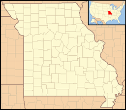
- Crowder State Park
-
Crowder State Park Missouri State Park Country United States State Missouri County Grundy County Coordinates 40°5′32″N 93°39′33″W / 40.09222°N 93.65917°W Area 2.99 sq mi (8 km2) Founded 1938 Website: http://mostateparks.com/crowder.htm Crowder State Park is a 1,912 acre (7.7 km²) park near Trenton, Missouri, USA. It surrounds Crowder Lake in Grundy County. Both are named after Maj. General Enoch H. Crowder, an officer in the United State Military who was born and raised near the park.
Contents
Features
Camping: Campsites with and without electricity are available from March through November each year. Services offered include a dump station, laundry, showers, and firewood sales. The use of private generators is prohibited except by special pre-approval from the park manager. A special group camp is also available for reservation.
Fishing & Boating: 18-acre (73,000 m2) Crowder Lake offers fishing for a variety of species. Most cmmon are channel catfish, bluegill, large-mouth bass, and crappie. Boating with electric trolling motors is allowed, however no boat rentals or other marina activities are offered. Gasoline-powered boat motors are prohibited.[1]
Swimming: A swimming area is available with sand beach and bathhouse/changing area.
Day Activities: Twenty-five picnic areas are available throughout the park including one enclosed shelter and two open shelters that can be reserved in advance. Two playgrounds provide entertainment for children. Hiking, mountain biking, and equestrian trails also loop through Crowder State Park.[2] The park also features a paved tennis court.
See also
References
External links
Protected Areas of Missouri Federal National Wildlife Refuges:Big Muddy • Clarence Cannon • Great River • Middle Mississippi River • Mingo • Ozark Cavefish • Pilot Knob • Squaw Creek • Swan Lake • Two RiversNational Forests:State Babler • Sam A. Baker • Bennett Spring • Big Lake • Big Oak Tree • Big Sugar Creek • Castlewood • Crowder • Cuivre River • Current River • Elephant Rocks • Finger Lakes • Graham Cave • Grand Gulf • Ha Ha Tonka • Harry S Truman • Hawn • Johnson's Shut-Ins • Jones-Confluence Point • Katy Trail • Knob Noster • Lake of the Ozarks • Lake Wappapello • Lewis and Clark • Long Branch • Mark Twain • Meramec • Montauk • Morris • Onondaga Cave • Pershing • Pomme de Terre • Prairie • Roaring River • Robertville • Rock Bridge Memorial • Route 66 • St. Francois • St. Joe • Stockton • Table Rock • Taum Sauk Mountain • Thousand Hills • Trail of Tears • Van Meter • Wakonda • Wallace • Washington • Watkins Woolen Mill • Weston BendArrow Rock • Battle of Athens • Battle of Carthage • Battle of Lexington • Thomas Hart Benton Home and Studio • Bollinger Mill • Nathan Boone Homestead • Boone's Lick • Bothwell Lodge • Clark's Hill/Norton • Confederate Memorial • Deutschheim • Dillard Mill • Gov. Daniel Dunklin's Grave • Felix Vallé House • First Missouri State Capitol • Fort Davidson • Gen. John J. Pershing Boyhood Home • Harry S Truman Birthplace • Hunter-Dawson • Iliniwek Village • Jefferson Landing • Jewell Cemetery • Locust Creek Covered Bridge • Mark Twain Birthplace • Mastodon • Missouri Mines • Missouri State Capitol • Missouri State Museum • Osage Village • Sandy Creek Covered Bridge • Sappington Cemetery • Scott Joplin House • Towosahgy • Union Covered Bridge • Watkins Woolen MillConservation areas:List of Missouri conservation areasCategories:- Geography of Grundy County, Missouri
- Missouri state parks
- National Register of Historic Places in Missouri
- Protected areas established in 1938
- Missouri geography stubs
Wikimedia Foundation. 2010.

