- Golestan Province
-
For other uses, see Gulistan (disambiguation).
Golestan Province
استان گلستان— Province — Location of Golestān within Iran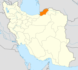
Coordinates: 36°50′21″N 54°26′40″E / 36.8393°N 54.4444°ECoordinates: 36°50′21″N 54°26′40″E / 36.8393°N 54.4444°E Country  Iran
IranCapital Gorgan Counties 12 Area[1] – Total 20,367 km2 (7,863.7 sq mi) Population (2006)[2] – Total 1,617,087 – Density 79.4/km2 (205.6/sq mi) Time zone IRST (UTC+03:30) – Summer (DST) IRST (UTC+04:30) Main language(s) Mazandarani
Turkmen
PersianGolestan Province (Persian: استان گلستان, Ostān-e Golestān ) is one of the 31 provinces of Iran, located in the north-east of the country, south of the Caspian Sea. Its capital is Gorgan.
Golestān was split off from the province of Mazandaran in 1997. It has a population of 1.6 million (2006) and an area of 20,380 km². The major townships of the province are: Gorgan, Gonbad Kavoos, Bandar Torkaman, Bandar Gaz, Aliabad-e katul, Kord Kooy, Fenderesk and Minoo Dasht. Present-day Gorgan was called Esteraba or Astarabad until 1937.
Contents
The name
Gorgān, Hyrcania in Latin, the district of "the wolves" (still seen thereabouts), is mentioned already as Varkāna- in the Behistun inscription.[3]
History
Human settlements in this area date back to 10 000 BCE. Evidence of the ancient city of Jorjan can still be seen near the current city of Gonbad-e Kavus. This was an important city of Persia, located on the Silk Road.
Under the Achaemenid Iran, it seems to have been administered as a sub-province of Parthia and is not named separately in the provincial lists of Darius and Xerxes. The Hyrcanians, however, under the leadership of Megapanus, are mentioned by Herodotus[4] in his list of Xerxes’ army during the invasion of Greece.[3]
Demography
The Turkmens reside in the north of the province, a plain called Turkmen Sahra, this former nomadic people live in this area from 15th century, main cities of whom is Gonbad-e Kavus and Bandar Torkaman. recent decades has seen a huge migration to this province, especially from Zabol northest city of Sistan and Baluchestan. They are a sizable minority at cities such as Gorgan, Ali Abad, Kalaleh and many of eastern townships.
Other ethnic groups such as Azerbaijanis, Baluchs, Kazakhs, Qezelbashs, Kurds, Georgians, and Armenians also reside in this area, and have preserved their traditions and rituals.
Turkmens are Muslim and belong to Hanafi school of sunni sect. small minorities; Baluchs and Kazakhs are also Hanafi.
Persian and Mazandarani languages speakers are mainly shia, official religion of Iran with Azeris, Kurds and Qezelbashs.
A small minority of Bahá'í Faith also Live in Golestan (in Shahpassand).
Culture
The Buwayhid and Ziyarid dynasties of Persia were from this region. They were known for the revival of pre-Islamic Persian culture. For example, Buwayhid leaders entitled themselves as Shâhanshâh (شاهنشاه), literally king of kings, a term used by Sassanid rulers.
The world's tallest brick tower stands in this province. It is the famous Gonbad-e Qabus, built by a famous Amir of this region.
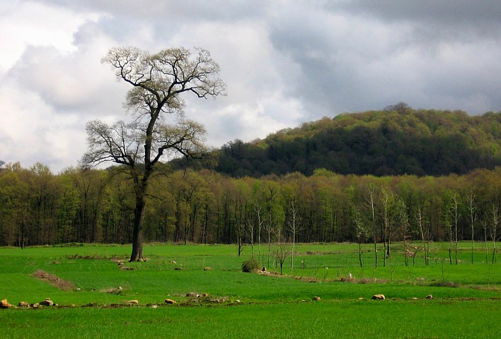
Climate and geography
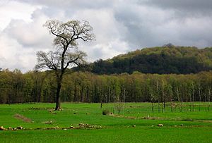 Landscape in Golestan
Golestān enjoys mild weather and a temperate climate most of the year. Geographically, it is divided into two sections: The plains, and the mountains of the Alborz range. In the eastern Alborz section, the direction of mountains faces northeast and gradually decreases in height. The highest point of the province is Shavar, with a height of 3,945 meters.
Golestan National Park
Golestan National Park in northern Iran is faced with the construction of a road through the forest, allegedly for the ease of traffic for villagers and woodmen but at the expense of losing the only national park in Iran throughout which a range of different climates (humid near the Caspian Sea and desert farther south) is spread.
Golestan National Park is Iran's biggest national park which spans three provinces, Golestan, Mazandaran and North Khorasan. Surprisingly, the authorities ignore repeated calls by experts to construct such roads around, instead of through, the forests, which in this way would no longer threaten the animal and plant life.
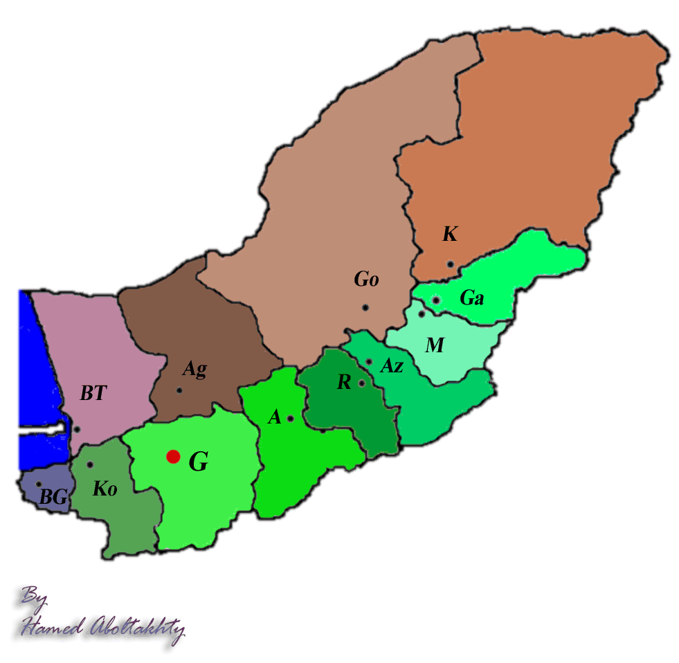
Administrative divisions
Map Abbreviation in map County (Shahrestan) 
A Aliabad-e Katul Az Azadshahr BT Bandar-e Torkaman K Kalaleh G Gorgan Go Gonbad Kavoos Ko Kordkooy Ga Galikesh M Minoodasht R Ramiyan BG Bandar-e Gaz Ag Agh Ghala Colleges and universities
- Gorgan University of Agricultural Sciences and Natural Resources (website)
- Golestan University of Medical Sciences
- Islamic Azad University of Azadshahr
- Islamic Azad University of Gorgan
- Islamic Azad University of Ali Abad katool
References
External links

Balkan Province,  Turkmenistan
Caspian Sea 
North Khorasan Province  Golestan Province

Mazandaran Province Semnan Province  Golestan Province
Capital 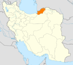
Counties and Cities Aliabad-e Katul · FazelabadAqqala · AnbaralumGonbad-e-Qabus CountyKalaleh CountyKalalehTorkaman CountySights Alma gol lake · Alangdareh · Ashuradeh · Great Wall of Gorgan · Golestan National Park · Gonbad-e Qabus Tower · ShirAbad Waterfall · Kaboud-val · Naharkhoran · Gomishan lake · Voshmgir dam · Miankaleh peninsula · Makhtum Quli Farghi's mausoleum · Radkan DomeProvinces of Iran Alborz · Ardabil · Bushehr · Chaharmahal and Bakhtiari · East Azerbaijan · Isfahan · Fars · Gilan · Golestan · Hamadan · Hormozgan · Ilam · Kerman · Kermanshah · Khuzestan · Kohgiluyeh and Boyer-Ahmad · Kurdistan · Lorestan · Markazi · Mazandaran · North Khorasan · Qazvin · Qom · Razavi Khorasan · Semnan · Sistan and Baluchestan · South Khorasan · Tehran · West Azerbaijan · Yazd · Zanjan
 Categories:

Wikimedia Foundation. 2010.