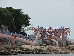
- Ca Mau province
-
Ca Mau province
Tỉnh Cà Mau— Province — Da Bac Islet in Ca Mau Nickname(s): Dark water Location of Cà Mau within Vietnam
Coordinates: 9°5′N 105°5′E / 9.083°N 105.083°ECoordinates: 9°5′N 105°5′E / 9.083°N 105.083°E Country  Vietnam
Region Mekong Delta Capital Cà Mau Government – People's Council Chair – People's Committee Chair Area[1] – Total 5,331 km2 (2,058.3 sq mi) Population (2006)[1] – Total 1,232,000 – Density 231.1/km2 (598.5/sq mi) Demographics – Ethnicities Vietnamese, Khmer, Hoa, Tày Time zone ICT (UTC+7) Calling code 780 ISO 3166 code VN-59 Website www.camau.gov.vn Cà Mau (
 listen) is a province of Vietnam, named after its capital city. It is located in the Mekong Delta of southern Vietnam, and is the southernmost of Vietnam's 58 provinces. It is bordered on the north by the Kiên Giang and Bạc Liêu provinces, on the west by the Gulf of Thailand, and on the south and east by the South China Sea (often referred to as the "East Sea".)[2] Its name came from the Khmers who inhabited the area before the arrival of the Vietnamese, cà mau means "black" in Khmer.
Contents
Economy
Being surrounded by sea on three sides, fishing is an important industry in Cà Mau province. An extensive network of canals also supports a strong agricultural sector, as well as providing a popular means of transport. The U Minh biosphere reserve and Mũi Cà Mau, the southernmost point of Vietnam, serve also as important tourism destinations. The Mũi Cà Mau National Park is located at Mũi Cà Mau.
Name
Its name came from the Khmers who inhabited the area before the arrival of the Vietnamese, Cà Mau means "black" in Khmer. The Khmer name for this province is Tuk Khmao.
Administration
Politically, Cà Mau is divided into eight districts:[3]
The provincial capital, also named Cà Mau, is a separate municipality.
1997 Typhoon
In November 1997, the Cà Mau peninsula was struck by Typhoon Linda (Openg). Thousands of people were lost, and an estimated 200,000 homes were destroyed, along with much of the Cà Mau fishing fleet.[4]
References
- ^ a b General Statistics Office of Vietnam. "Population and Employment: Population and population density in 2006 by province". 7. http://www.gso.gov.vn/default_en.aspx?tabid=467&idmid=3&ItemID=6173. Retrieved 2008-05-31.
- ^ CA MAU PEOPLE'S COMMITTEE. "Introduction: Geographical Position". http://www.camau.gov.vn/index.php?o=modules&n=info&f=intro&root=1&idmenu=11&id=89. Retrieved 2008-05-31.
- ^ CA MAU PEOPLE'S COMMITTEE. "Towns, Districts: Overview". http://www.camau.gov.vn/index.php?o=modules&n=info&f=intro&root=1&idmenu=210&id=212. Retrieved 2008-05-31.
- ^ Dodd, Jan, et al. (2003). "The Rough Guide to Vietnam". Rough Guides. http://books.google.com/books?id=7WvOSgCHrOoC&pg=RA1-PA164&dq=%22Ca+Mau%22&as_brr=3&client=firefox-a&sig=dSkMGS9qjVYFTtrnb2LTnHCFRrM#PRA1-PA163,M1. Retrieved 2008-06-02.
External links

Kien Giang province Bac Lieu province 
Gulf of Thailand 
 Ca Mau province

South China Sea Subdivisions of Vietnam Regions Municipalities Can Tho · Da Nang · Hai Phong · Hanoi · Ho Chi Minh City
Provinces An Giang · Bac Giang · Bac Kan · Bac Lieu · Bac Ninh · Ba Ria-Vung Tau · Ben Tre · Binh Dinh · Binh Duong · Binh Phuoc · Binh Thuan · Ca Mau · Cao Bang · Dak Lak · Dak Nong · Dien Bien · Dong Nai · Dong Thap · Gia Lai · Ha Giang · Ha Nam · Ha Tinh · Hai Duong · Hoa Binh · Hau Giang · Hung Yen · Khanh Hoa · Kien Giang · Kon Tum · Lai Chau · Lam Dong · Lang Son · Lao Cai · Long An · Nam Dinh · Nghe An · Ninh Binh · Ninh Thuan · Phu Tho · Phu Yen · Quang Binh · Quang Nam · Quang Ngai · Quang Ninh · Quang Tri · Soc Trang · Son La · Tay Ninh · Thai Binh · Thai Nguyen · Thanh Hoa · Thua Thien-Huế · Tien Giang · Tra Vinh · Tuyen Quang · Vinh Long · Vinh Phuc · Yen Bai
Categories:
Wikimedia Foundation. 2010.


