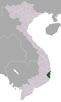
- Khanh Hoa Province
Infobox province of Vietnam
Name = Khánh Hòa
Meaning =
Council Chair = Mai Trực
Committee Chair = Võ Lâm Phi
Capital =Nha Trang
Region = South Central Coast
Area = 5,197
Population = 1,080,800
Population year = 2004
Population density = 257.5
Ethnicities = Vietnamese,Ra Glai ,Hoa , Cơ Ho
Calling code = 58
ISO code = VN-34
Website = http://www.khanhhoa.gov.vn/Khánh Hòa Province audio|Khanh Hoa.ogg|pronunciation (
Hán tự : ) is a province ofVietnam , located in the South Central Coast. It has a population of 1,066,300 and spans an area of 5,197 km². Its capital isNha Trang . Khánh Hòa is the site of the last Nguyễn Emperor Bảo Đại's summer home, thePasteur Institute foroceanography , and the Green Berets' headquarters during theVietnam War in the late 1950s and 1960s.Cam Ranh Bay port is on land closest to a deep sea drop in Vietnam - the best site forsubmarine bases in Vietnam. An ancient Cham temple exists on the north side of Nha Trang.Geography and climate
Khánh Hòa Province has an area of 5,197 km². Its geographical coordinates are 108°40’33" to 109°27’55" E and 11°42’50" to 12°52’15" N. The provincial coastline spreads from Đại Lãnh Commune to the end of
Cam Ranh Bay with a total length of coastline of 385 km featuring numerous creek mouths, lagoons, river mouths, and hundreds of islands and islets. The province also administers large territorial waters. TheSpratly Islands are part of the province's Truong Sa County. The coastline is indented by several bays, most notably the four baysVân Phong Bay ,Nha Phu Bay ,Nha Trang Bay (Cù Huân) andCam Ranh Bay , of which Cam Ranh Bay with its area of around 200 km², encompassed by a mountain range, is regarded as one of three best natural seaports in the world.Cam Ranh Bay , a strategically important bay, was used as a naval base by the French colonists duringFrench Indochina , by the Russian navy in theRusso-Japanese War in the early 20th century, by the Japanese army to conquerMalaysia inWorld War II , and was used as well by the United States army duringVietnam War . After theFall of Saigon in 1975, Cam Ranh Bay was leased to theUSSR for use as a Soviet naval base. This lease was originally scheduled to expire in 2004, but this was shortened by two years. Today, the government of Vietnam plans to turn part of the base to civilian and commercial use.Hon Doi Cliff (Mũi Hòn Đôi) on the Hòn Gốm Peninsula, Vạn Ninh County is the easternmost tip of Vietnam's mainland.The province enjoys a mild climate with an average annual temperature of 26.7°C. There are two distinct seasons: the rainy season lasts from April to December, with the other months being the dry season, except inNha Trang where the rainy season lasts for just two months. The average relative humidity is 80.5%. The climate on the summit of Hòn Bà Mountain (located 30 km from Nha Trang) features a climate like that ofDalat and Sapa.Administrative divisions
Khanh Hoa Province is divided into the following districts:
*Nha Trang (city)
*Cam Ranh (town)
*Cam Lâm
*Diên Khánh
*Khánh Sơn
*Khánh Vĩnh
*Ninh Hòa
*Trường Sa (also known as theSpratly Islands )
*Vạn NinhDemographics
As of 2006 , the province has a population of 1.3 million, of which the majority areKinh (the dominant ethnic group in Vietnam). Minority peoples dwelling in the province are theRa Glai , theHoa (Han Chinese), and theCo Ho .History
The site of what is now Khanh Hoa had been within the territory of the
Champa Kingdom before it was annexed to Dai Viet’s (Viet Nam's) territory. In 1653, one of theNguyen lords ,Nguyễn Phúc Tần , sent his troops to occupyPhan Rang . The Champa kingBà Tấm surrendered to Nguyen's troops and ceded an area from the east of thePhan Rang River toPhú Yên to the Nguyen lord. The Nguyễn lord accepted the ceded territory and set up the Thái Khang garrison and divided it into two districts: Thái Khang and Diên Ninh.In 1832, under the rule of emperor
Minh Mang , this area was renamed Khánh Hòa and was divided into two districts which included four counties: Phủ Diên Khánh inclusive of Phước Điền and Vĩnh Xương county; Phủ Ninh Hòa inclusive of Quảng Phước and Tân Định county.Under
French Indochina , the provincial capital was located in Diên Khánh Citadel, but it was relocated in Nha Trang Town in 1945.After the communists' victory and the
Fall of Saigon on April 30, 1975, the united government merged two provinces,Phú Yên and Khánh Hòa, into Phú Khánh Province on29 October 1975 . In 1977, Nha Trang Town was upgraded to city status. In 1982, the National Assembly decided to incorporate theSpratly Islands into Phú Khánh Province. OnJune 30 , 1989, the National Assembly reversed its previous decision and split Phú Khánh Province into two provinces as they were before.Economy
Tourism and services play a principal role in the province’s economic sectors. The province is endowed with beautiful natural landscapes and the development of tourism in Khanh Hoa relies largely on its natural beauty. Peasants in the province live by
rice cultivation; nevertheless, this province is not a rice bowl of the country and the gross agricultural production is insignificant. The largest contributor to the local budget is heavy industry, especially the shipbuilding industry. The abundance of white sand and titanium deposits in the seaside areas makes this province a potential crystal and titanium production site. The province also owns significant gold ore deposits.As a coastal province featuring several natural deep water bays, Khanh Hoa has what is needed to develop its deep-water seaports. Nha Trang Port (a tourist and cargo port) and Doc Let Port (a shipbuilding and logistics port) are now in use. A megaproject intended to be developed in
Van Phong Bay by a consortium of Japanese corporations (with Sumitomo as the leading investor) with an estimated investment of US$15 billion (15*10^9) is in progress. On completion, this deep sea port will be capable of handling ships up to 100,000 tonnes and of 100 million tonnes of loaded/unloaded cargo per annum.Education
Khanh Hoa is one of the most important educational centers in Vietnam. It is home to
Nha Trang University (formerly Nha Trang Fishery University), amultidisciplinary university; the Naval Academy; the Air Force Officer Academy; a Normal College; a Kindergarten Teacher's Training College; and an Arts and Tourism College.External links
* [http://www.khanhhoa.gov.vn Official website of the provincial government]
* [http://www.baokhanhhoa.com.vn Official news agency off the province]
* [http://www.baokhanhhoa.com.vn/BanDo/gioithieu/gt.htm Khanh Hoa Province map]
* [http://nhatrang.online.fr]
* [http://vinpearlland.com]
* [http://www.ven.vn/festivalbien Nha Trang Sea Festtival Website]
* [http://www.nhatrang-travel.com/ Tour Guide to Nha Trang]
* [http://www.khanhhoaonline.com Khanh Hoa Online]
* [http://festivalbienkhanhhoa.com About Nha Trang Festival]
Wikimedia Foundation. 2010.