- 1997 Pacific typhoon season
Infobox hurricane season
Track=1997 Pacific typhoon season summary.jpg
Basin=WPac
Year=1997
First storm formed=January 19 ,1997
Last storm dissipated=December 22 ,1997
Strongest storm name=Ivan, Joan, Keith
Strongest storm pressure=872
Strongest storm winds=160
Total storms=29
Total hurricanes=24
Total intense=11
Fatalities=515
five seasons=1995, 1996, 1997, 1998, 1999The 1997 Pacific typhoon season has no official bounds; it ran year-round in 1997, but most
tropical cyclones tend to form in the northwesternPacific Ocean between May and November. [Gary Padgett. [http://www.typhoon2000.ph/garyp_mgtcs/may03sum.txt May 2003 Tropical Cyclone Summary.] Retrieved on2006-08-26 .] These dates conventionally delimit the period of each year when most tropical cyclones form in the northwesternPacific Ocean .The scope of this article is limited to the Pacific Ocean, north of the equator and west of the
International Date Line . Storms that form east of the Date Line and north of the equator are called hurricanes; see1997 Pacific hurricane season . Tropical Storms formed in the entire west Pacific basin were assigned a name by theJoint Typhoon Warning Center . Tropical depressions in this basin have the "W" suffix added to their number. Tropical depressions that enter or form in the Philippine area of responsibility are assigned a name by thePhilippine Atmospheric, Geophysical and Astronomical Services Administration or PAGASA. This can often result in the same storm having two names.torms
The season was unusual in the number of super typhoons that occurred in the basin, with eleven typhoons reaching winds of at least 135 knots. They were Isa, Nestor, Rosie, Winnie, Bing, Oliwa (from Central Pacific), Ginger, Ivan, Joan, Keith, and Paka (from Central Pacific). This was due to the strong El Niño of 1997-1998, which contributed to the record amounts of not only super typhoons but also tropical storms in the Western and Eastern Pacific. Fortunately, most of the stronger systems remained at sea.
Tropical Storm Hannah (Atring)
Infobox Hurricane Small
Basin=WPac.png)
Track=Hannah 1997 track.pngJanuary 19
Dissipated=January 27
1-min winds=50
Pressure=987equator ial trough just west of theInternational Date Line . It tracked steadily westward, and remained disorganized for about week. OnJanuary 18 , deep convection increased as a low-level circulation began to form, and at 0000 UTC onJanuary 19 it developed into Tropical Depression 01W while located to the southwest ofGuam . Based on satellite imagery estimates, theJoint Typhoon Warning Center upgraded it to Tropical Storm Hannah six hours after first forming. The deep convection quickly organized into well-defined cyclonic bands, and early onJanuary 20 Hannah attained its peak intensity of 60 mph near the island ofYap . Increased southeasterlywind shear weakened the storm, leaving its dwindling convection situated along the northern portion of the circulation. Interaction with a large and powerfulextratropical cyclone left the storm moving erratically, and onJanuary 22 Hannah weakened to tropical depression status. Its motion turned to a steady southwestward motion, and onJanuary 27 Hannah dissipated a short distance east of the Philippine island ofMindanao .cite web|author=Joint Typhoon Warning Center|year=1999|title=Tropical Storm Hannah (01W) ATCR|accessdate=2007-04-19|url=https://metocph.nmci.navy.mil/jtwc/atcr/1997atcr/ch3/01ww.htm]Near the end of its duration, the
Philippine Atmospheric, Geophysical and Astronomical Services Administration began issuing warnings on Hannah when was a tropical depression; the institution named the storm Tropical Depression Atring.cite web|author=The United Nations Task Force on El Niño, et. al|year=1999|title=The 1997-1998 El Niño Event: A Scientific and Technical Retrospect|publisher=World Meteorological Organization|accessdate=2007-04-19|url=http://web.archive.org/web/20060311135947/http://www.wmo.ch/nino/WMO905-e.pdf] The storm was never tracked by theJapan Meteorological Agency . There were no reports of significant damage or injuries.uper Typhoon Isa
Infobox Hurricane Small
Basin=WPac.png)
Track=Isa 1997 track.pngApril 9
Dissipated=April 24
1-min winds=145
Pressure=892monsoon trough near theCaroline Islands onApril 12 . It moved erratically at first, though after attaining tropical storm status it curved westward due to thesubtropical ridge to its north. Isa very gradually intensified, and onApril 20 the typhoon reached peak 1-min winds of 270 km/h (165 mph), as reported by the Joint Typhoon Warning Center; Japan Meteorological Agency reported maximum 10-min winds of 155 km/h (100 mph). After turning northward, it accelerated to the northeast, and merged with a largerextratropical cyclone onApril 24 .cite web|author=Joint Typhoon Warning Center|year=1999|title=Typhoon Isa (02W) ATCR|accessdate=2007-04-26|url=https://metocph.nmci.navy.mil/jtwc/atcr/1997atcr/ch3/02ww.htm]Early in its duration, Isa caused light rainfall and moderate winds on
Pohnpei . Later, a stationary rainband from the typhoon dropped heavy precipitation onGuam during its dry season. Damage in the GuamNational Weather Service area of responsibility totaled $1 million (1997 USD, $1.3 million 2006 USD), the majority of it from crop damage. No deaths were reported.cite web|author=National Climatic Data Center|year=1997|title=Event Report for Typhoon Isa|accessdate=2007-04-26|url=http://www4.ncdc.noaa.gov/cgi-win/wwcgi.dll?wwevent~ShowEvent~315211]Tropical Storm Jimmy
Infobox Hurricane Small
Basin=WPac.png)
Track=Jimmy 1997 track.pngApril 22
Dissipated=April 26
1-min winds=55
Pressure=984equator ial westerly wind system developed an area of convection onApril 18 , the same system that previously developed Typhoon Isa. It drifted west-northwestward, and onApril 21 separated from the westerly wind system. At 0400 UTC onApril 22 , theJoint Typhoon Warning Center (JTWC) issued aTropical Cyclone Formation Alert on the system, and two hours later the JTWC issued the first warning on Tropical Storm Jimmy about 1360 km (845 mi) southeast ofGuam .cite web|author=Joint Typhoon Warning Center|year=1999|title=Tropical Storm Jimmy (03W) ATCR|accessdate=2007-04-20|url=https://metocph.nmci.navy.mil/jtwc/atcr/1997atcr/ch3/03ww.htm] Coinciding with its first warning, theJapan Meteorological Agency (JMA) classified it as a tropical depression.cite web|author=Japan Meteorological Agency|year=1997|title=1997 Western Pacific Best Track|accessdate=2007-04-20|url=http://www.jma.go.jp/jma/jma-eng/jma-center/rsmc-hp-pub-eg/Besttracks/bst1997.txt]Jimmy continued northwestward through a break in the subtropical ridge caused by Isa, and it steadily intensified as it tracked through an area of light vertical
wind shear . It recurved to the northeast, and shortly after reaching its westernmost point Jimmy attained its peak intensity of 55 mph onApril 24 . Conversely, JMA assessed Jimmy as remaining a minimal tropical storm throughout its duration. After maintaining peak winds for about 18 hours, to increased southwesterly winds aloft quickly weakened the storm, and late onApril 25 JTWC issued its final advisory on Jimmy after its low-level circulation center became completely exposed from the deep convection. OnApril 26 , Jimmy was absorbed by an approaching frontal trough over the openPacific Ocean . The storm had little effects on land.Tropical Storm Kelly
Infobox Hurricane Small
Basin=WPac
Track=Kelly 1997 track.pngMay 4
Dissipated=May 11
1-min winds=45
Pressure=991equator ial trough developed an area of convection onMay 4 . The low strengthened as it became more organized over the next two days. Late onMay 6 , the JTWC issued a TCFA and the system was declared Tropical Depression 04W shortly after. The depression slowly intensified and was upgraded to a Tropical Storm early onMay 8 and was named Kelly. Kelly was able to intensify slightly before strong vertical wind shear displaced the center, weakening Kelly. Kelly was downgraded to a Tropical Depression onMay 10 and the remnant circulation dissipated the next day. [http://metocph.nmci.navy.mil/jtwc/atcr/1997atcr/pdf/wnp/04w.pdf]Tropical Storm Levi (Bining)
Infobox Hurricane Small
Basin=WPac
Track=Levi 1997 track.pngMay 25
Dissipated=June 4
1-min winds=45
Pressure=991Philippines in late May. The heavy rain it brought caused mudslides that killed 33 people. The depression continued northeastward, becoming a tropical storm, and transitioning to an extratropical storm onMay 30 . [Joint Typhoon Warning Center. [https://metocph.nmci.navy.mil/jtwc/atcr/1997atcr/ch3/05ww.htm Tropical Storm Levi.] Retrieved on2007-01-07 .]From May 26-29,
Philippine Atmospheric, Geophysical and Astronomical Services Administration tracked the storm, and named it Bining.Typhoon Marie
Infobox Hurricane Small
Basin=WPac
Track=Marie 1997 track.pngMay 25
Dissipated=June 2
1-min winds=90
Pressure=954uper Typhoon Nestor
Infobox Hurricane Small
Basin=WPac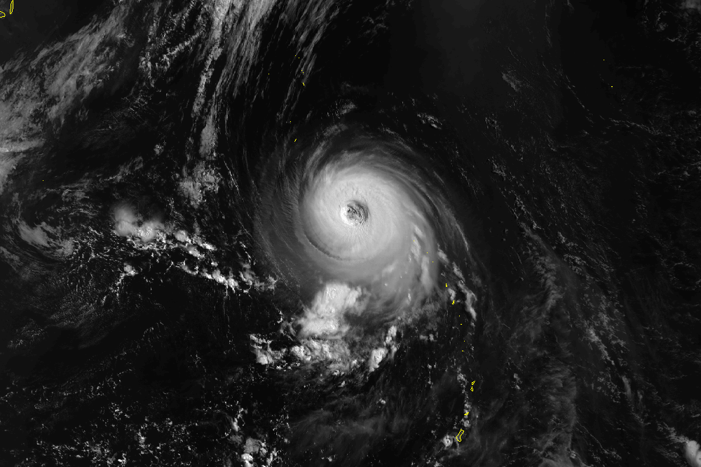
Track=Nestor 1997 track.pngJune 1
Dissipated=June 15
1-min winds=140
Pressure=898Typhoon Opal (Kuring)
Infobox Hurricane Small
Basin=WPac
Track=Opal 1997 track.pngJune 13
Dissipated=June 21
1-min winds=90
Pressure=954Philippine Atmospheric, Geophysical and Astronomical Services Administration tracked the storm, and named it Kuring.Typhoon Peter (Daling)
Infobox Hurricane Small
Basin=WPac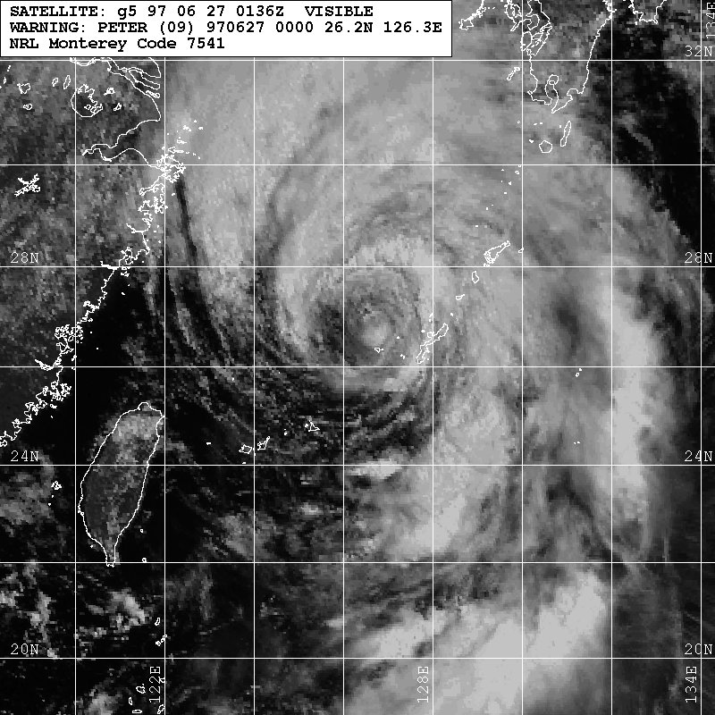
Track=Peter 1997 track.pngJune 23
Dissipated=June 30
1-min winds=70
Pressure=972Philippine Atmospheric, Geophysical and Astronomical Services Administration tracked the storm, and named it Daling.uper Typhoon Rosie (Elang)
Infobox Hurricane Small
Basin=WPac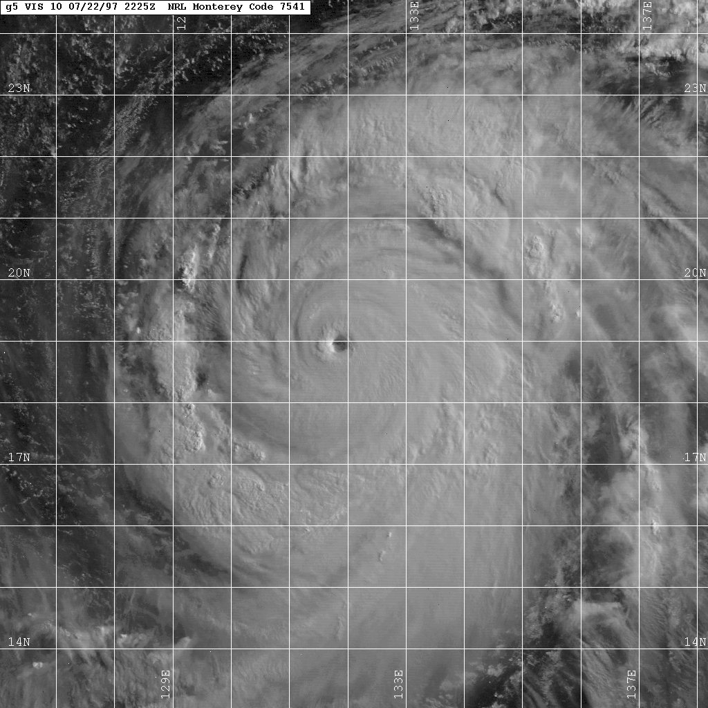
Track=Rosie 1997 track.pngJuly 18
Dissipated=July 29
1-min winds=140
Pressure=898July 18 , Tropical Depression 10W formed nearCaroline Islands . 10W was upgraded to Tropical Storm Rosie and became a Category 5 Super Typhoon onJuly 22 . Rosie moved northward and began to weaken. Rosie made a landfall as a Category 1 typhoon at Shikoku, Japan onJuly 26 . Two people were killed because of Rosie. [Joint Typhoon Warning Center. [https://metocph.nmci.navy.mil/jtwc/atcr/1997atcr/ch3/10ww.htm Super Typhoon Rosie (10W).] Retrieved on2007-01-07 .]From July 22-26,
Philippine Atmospheric, Geophysical and Astronomical Services Administration tracked the storm, and named it Elang.Tropical Storm Scott
Infobox Hurricane Small
Basin=WPac.png)
Track=Scott 1997 track.pngJuly 20
Dissipated=August 3
1-min winds=55
Pressure=984Tropical Upper Tropospheric Trough . The circulation built toward the surface, and byJuly 20 the system developed a low-level circulation with scattered associated convection.cite web|author=Joint Typhoon Warning Center|year=1999|title=Tropical Storm Scott (11W) ATCR|accessdate=2007-04-25|url=https://metocph.nmci.navy.mil/jtwc/atcr/1997atcr/ch3/11ww.htm] Based on its organization, theJapan Meteorological Agency (JMA) classified the system as a weak tropical depression early onJuly 20 while located about 820 km (510 mi) northeast ofFarallon de Pajaros , the northernmost island in theNorthern Mariana Islands . Early development was impeded by the outflow from Typhoon Rosie; after drifting northwestward for 2 days the system turned to the northeast, and byJuly 24 the influence from Rosie greatly diminished. Accordingly, the organization of the depression quickly increased, and onJuly 24 theJoint Typhoon Warning Center (JTWC) classified it as Tropical Depression 11W.A building
anticyclone to its northwest forced the depression southeastward. It became steadily less organized, and onJuly 26 JTWC issued a final warning on the system, believing it to be dissipating. Shortly thereafter, however, the system began re-organizing, and onJuly 27 the system developed into Tropical Storm Scott. The storm tracked northwestward, then westward, and finally turned to the northeast. Scott gradually strengthened to attain peak winds of 105 km/h (65 mph) onJuly 29 . JMA had upgraded the depression to tropical storm status onJuly 28 , and assessed its peak intensity at 75 km/h (45 mph). Scott maintained its peak intensity for about 12 hours before slowly weakening as it accelerated northeastward. OnAugust 2 , the storm merged with an approaching frontal trough, and the following day JMA considered Scott dissipated while located near theAlaska n island of Gareloi. Tropical Storm Scott never affected land. The storm was the only tropical cyclone during the season to not form from themonsoon trough .cite web|author=Joint Typhoon Warning Center|year=1999|title=Summary of Western North Pacific and North Indian Ocean Tropical Cyclones|accessdate=2007-04-25|url=https://metocph.nmci.navy.mil/jtwc/atcr/1997atcr/ch3/chap3.htm]Typhoon Tina (Huling)
Infobox Hurricane Small
Basin=WPac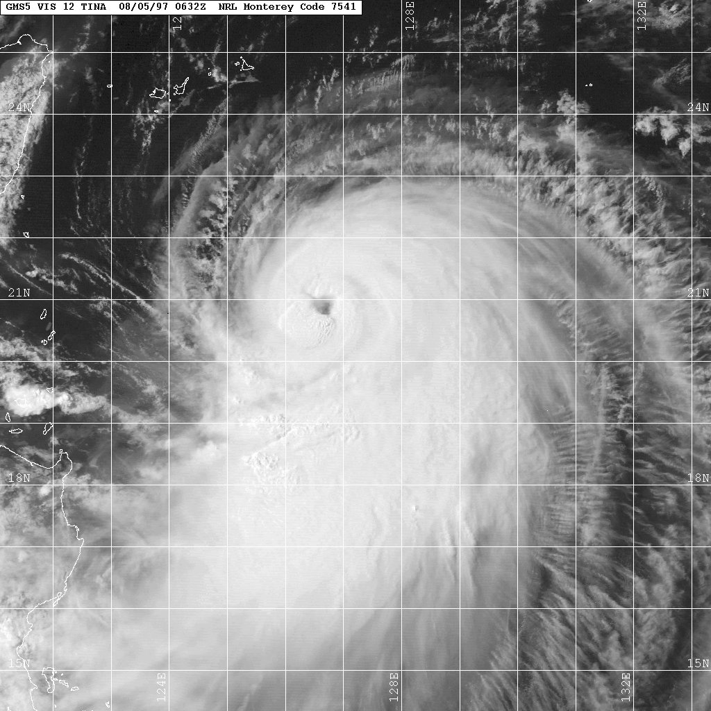
Track=Tina 1997 track.pngJuly 31
Dissipated=August 9
1-min winds=90
Pressure=954July 31 -August 6 ,Philippine Atmospheric, Geophysical and Astronomical Services Administration tracked the storm, and named it Bining.Typhoon Victor (Goring)
Infobox Hurricane Small
Basin=WPac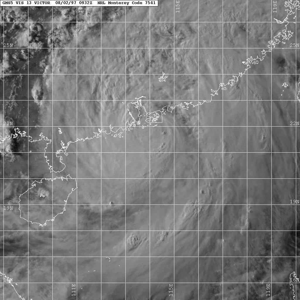
Formed=July 28
Dissipated=August 4
1-min winds=65
Pressure=976
Track=Victor 1997 track.pngFrom July 30-31,Philippine Atmospheric, Geophysical and Astronomical Services Administration tracked the storm, and named it Goring.uper Typhoon Winnie (Ibiang)
Infobox Hurricane Small
Basin=WPac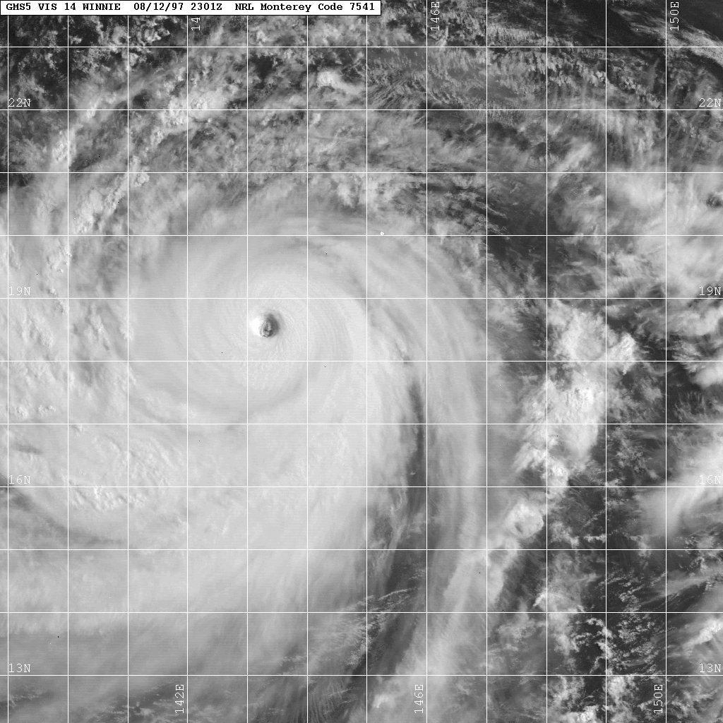
Track=Winnie 1997 track.pngAugust 5
Dissipated=August 23
1-min winds=140
Pressure=898August 5 , a tropical depression formed near theMarshall Islands . It headed northwestward, slowly strengthening to a tropical storm on the 9th. Intensification became more rapid as conditions became more favorable, and Winnie reached typhoon strength on the 10th. 2 days later, it became the 4th Super Typhoon of the season with peak winds of 160 mph. Soon after, the eye became ragged and large, with an outer eyewall reaching 200 miles in diameter. On the 18th, a minimal Typhoon Winnie passed north ofTaiwan and hit easternChina , where it winded down until dissipating on the 19th. The remnant continued northeastward, bringing heavy rain and damage across China until the 23rd. Winnie caused 64 deaths, 39 of which were in Taiwan from the heavy rain. [Joint Typhoon Warning Center. [https://metocph.nmci.navy.mil/jtwc/atcr/1997atcr/ch3/14ww.htm Super Typhoon Winnie (14W).] Retrieved on2007-01-07 .]Typhoon Yule
Infobox Hurricane Small
Basin=WPac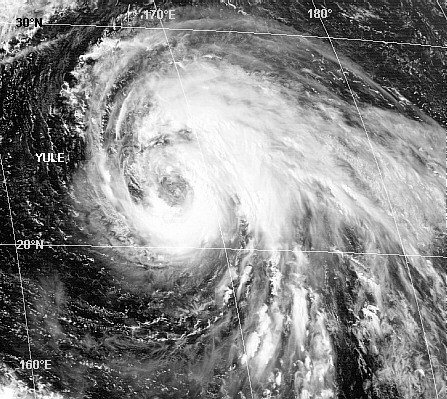
Track=Yule 1997 track.pngAugust 16
Dissipated=August 23
1-min winds=65
Pressure=976Typhoon Zita (Luming)
Infobox Hurricane Small
Basin=WPac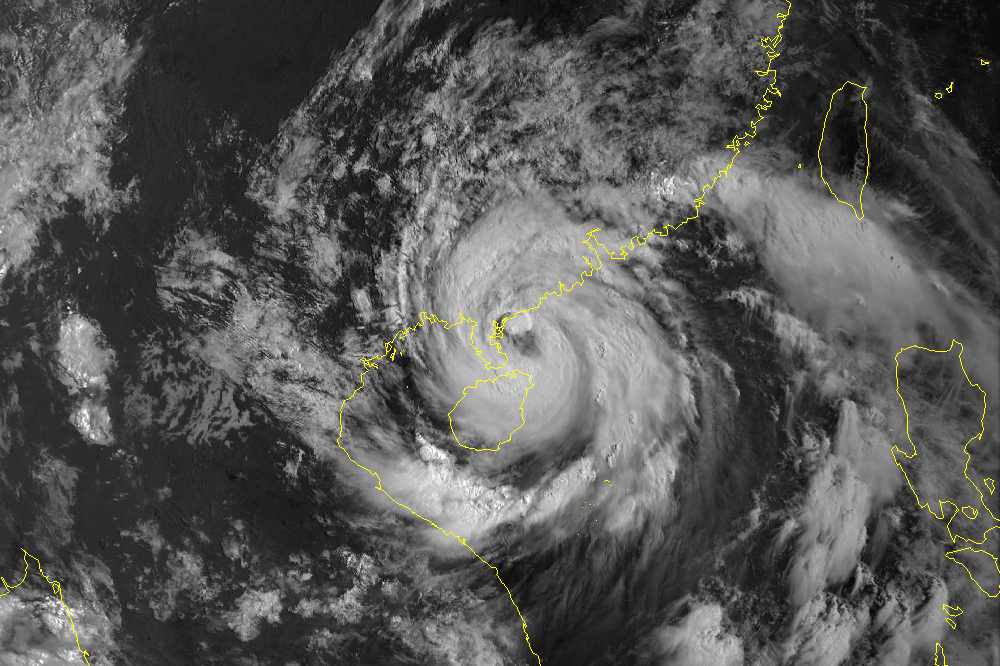
Track=Zita 1997 track.pngAugust 19
Dissipated=August 23
1-min winds=75
Pressure=967Philippine Atmospheric, Geophysical and Astronomical Services Administration tracked the storm early in its duration, and named it Luming.Typhoon Amber (Miling)
Infobox Hurricane Small
Basin=WPac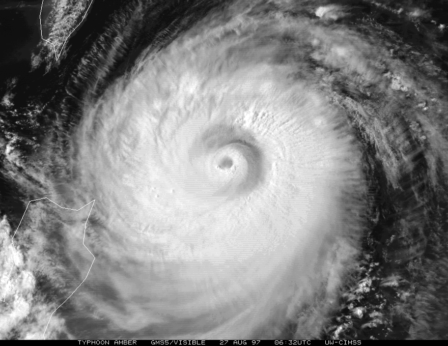
Track=Amber 1997 track.pngAugust 19
Dissipated=August 30
1-min winds=110
Pressure=933subtropical ridge and Typhoon Zita and developed at a faster than normal pace. ByAugust 26 , Tropical Storm Cass formed to the west-southwest, which accelerated Amber's forward motion to the northwest due to afujiwara interaction . It underwent eyewall replacement cycles fromAugust 25 throughAugust 27 , and tracked acrossTaiwan /Taipei with maximum sustained winds of 95 knots, then through theFormosa Strait intoChina as a minimal typhoon. [Joint Typhoon Warning Center. [https://metocph.nmci.navy.mil/jtwc/atcr/1997atcr/pdf/wnp/18w.pdf Typhoon Amber.] Retrieved on2007-01-07 .]Throughout much of its duration,
Philippine Atmospheric, Geophysical and Astronomical Services Administration tracked the storm, and named it Miling.uper Typhoon Bing
Infobox Hurricane Small
Basin=WPac
Track=Bing 1997 track.pngAugust 19
Dissipated=August 30
1-min winds=135
Pressure=904Tropical Storm Cass
Infobox Hurricane Small
Basin=WPac
Track=Cass 1997 track.pngAugust 28
Dissipated=August 30
1-min winds=45
Pressure=991uper Typhoon Oliwa
Infobox Hurricane Small
Basin=WPac
Track=Oliwa 1997 track.pngAugust 28
Dissipated=September 17
1-min winds=140
Pressure=898August 28 , the monsoon formed into Tropical Depression 2C in the Central Pacific. It headed slowly westward, becoming a tropical storm onSeptember 3 . It crossed theInternational Date Line , and continued to slowly strengthen to become a typhoon onSeptember 8 . Oliwa rapidly strengthened onSeptember 9 to reach a peak of 160 mph winds; the sixth Super Typhoon of the year. Oliwa slowly weakened as it moved westward, and hitJapan onSeptember 15 andSeptember 16 . It turned to the northeast, and dissipated onSeptember 17 after causing 7 deaths and widespread damage from flooding. [Joint Typhoon Warning Center. [https://metocph.nmci.navy.mil/jtwc/atcr/1997atcr/pdf/wnp/02cw.pdf Super Typhoon Oliwa (02C).] Retrieved on2007-01-07 .]Typhoon David
Infobox Hurricane Small
Basin=WPac
Track=David 1997 track.pngSeptember 11
Dissipated=September 20
1-min winds=95
Pressure=949Tropical Storm Ella
Infobox Hurricane Small
Basin=WPac
Track=Ella 1997 track.pngSeptember 21
Dissipated=September 23
1-min winds=40
Pressure=994Typhoon Fritz
Infobox Hurricane Small
Basin=WPac
Track=Fritz 1997 track.pngSeptember 23
Dissipated=September 26
1-min winds=75
Pressure=967uper Typhoon Ginger
Infobox Hurricane Small
Basin=WPac
Track=Ginger 1997 track.pngSeptember 21
Dissipated=October 1
1-min winds=145
Pressure=892Tropical Storm Hank
Infobox Hurricane Small
Basin=WPac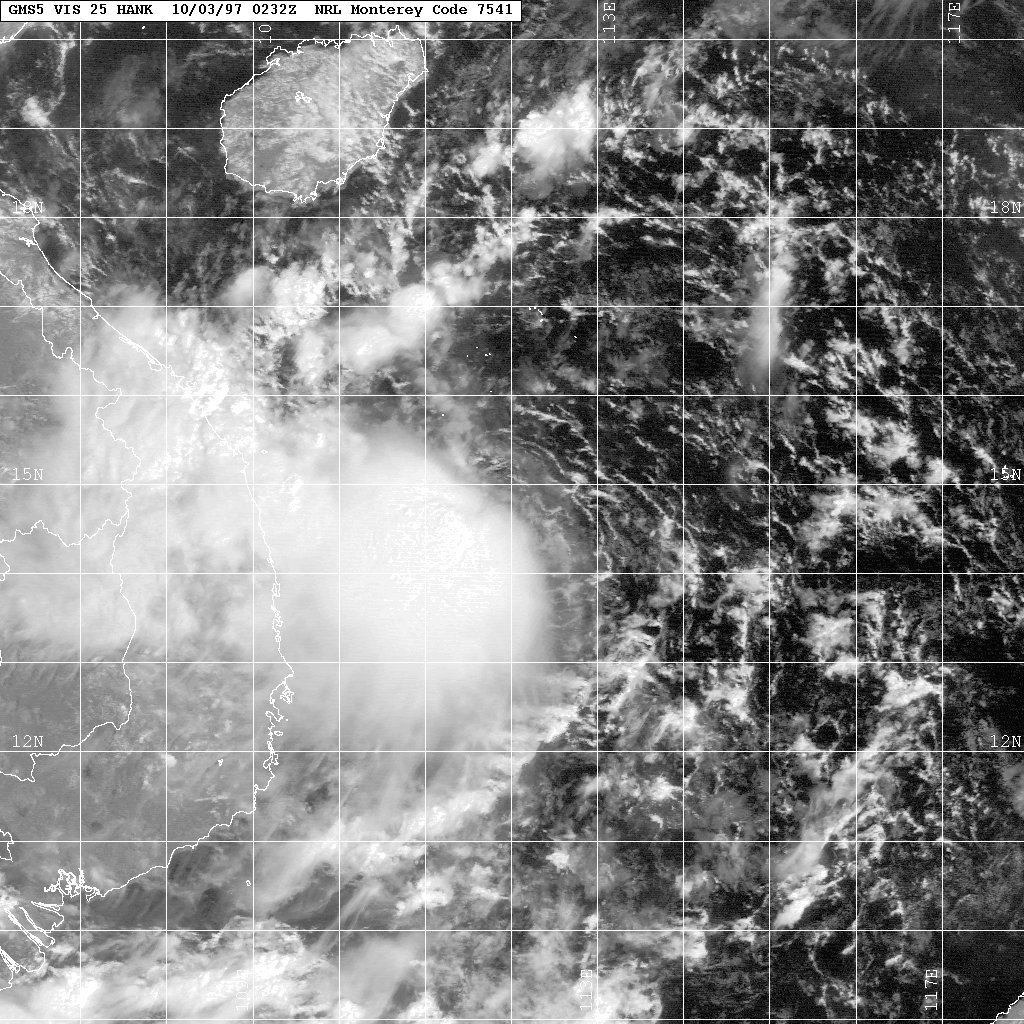
Track=Hank 1997 track.pngOctober 3
Dissipated=October 5
1-min winds=35
Pressure=997uper Typhoon Ivan (Narsing)
Infobox Hurricane Small
Basin=WPac
Track=Ivan 1997 track.pngOctober 9
Dissipated=October 26
1-min winds=160
Pressure=872October 9 andOctober 11 , respectively. Both poorly organized, they headed generally westward without much convection. On the 13th, 27W became Tropical Storm Ivan and on the 14th, 28W became Tropical Storm Joan. The two were within convert|500|nmi|km|abbr=off|lk=on of each other, but they were separate enough to strengthen on their own. On the 15th, while crossing theNorthern Mariana Islands , they both reached typhoon intensity. Rapid intensification came soon after, and Ivan and Joan became the 8th and 9th Super Typhoons of the year on the 17th. The two underwent theFujiwhara effect , bringing Ivan more westerly and Joan more northerly. After reaching peaks of convert|300|km/h|mph|abbr=on|lk=off winds within 12 hours of each other, they slowly weakened to Category 4's. Ivan struck the northernPhilippines at this intensity causing 1 death, while Joan restrengthened to a Category 5. They both turned to the northeast, and slowly dissipated.How they reached their extreme intensities at such a close distance to each other is unknown. Normally, when two
tropical cyclone s are relatively close to each other, one typically shears the other. In this case, they both maintained Category 5 intensity for at least a day within a relatively close distance of each other. The monsoon trough, which typically helps intensify Western Pacific typhoons, was absent from these storms. Pressures were higher than normal, and the initial disturbances were very poorly organized. Regardless, they are among the strongest Super Typhoons of the world with convert|300|km/h|mph|abbr=on|lk=off winds each. [Joint Typhoon Warning Center. [https://metocph.nmci.navy.mil/jtwc/atcr/1997atcr/ch3/27-28ww.htm Super Typhoons Ivan (27W) and Joan (28W).] Retrieved on2007-01-07 .]uper Typhoon Joan
Infobox Hurricane Small
Basin=WPac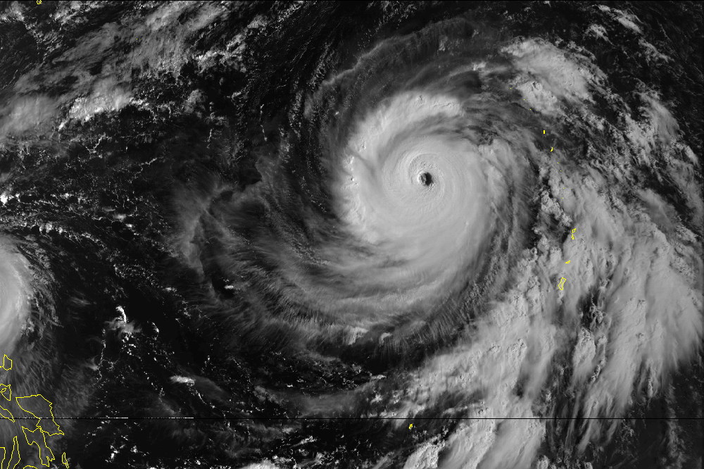
Track=Joan 1997 track.pngOctober 11
Dissipated=October 25
1-min winds=160
Pressure=872uper Typhoon Keith
Infobox Hurricane Small
Basin=WPac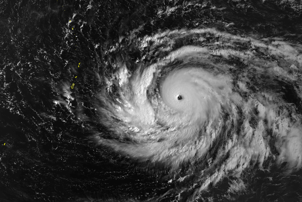
Track=Keith 1997 track.pngOctober 22
Dissipated=November 10
1-min winds=155
Pressure=872tropical cyclone s to attain super typhoon intensity in the westernNorth Pacific during 1997, Keith formed at low latitudes in theMarshall Islands . It was one of ten TCs which formed east of 160° E and south of 20° N — within the "El Niño ". Keith was a recurving TC which passed between the Islands of Rota and Tinian (only convert|50|nmi|km|abbr=on|lk=off|disp=s apart) on the west-bound leg of its recurving track. NEXRAD imagery fromGuam indicated the eye wall cloud of Keith never touched land as it threaded the narrow channel between these two islands. As such, theMariana Islands were spared the full force of Keith. Keith's compact wind and cloud structure were revealed by Guam's NEXRAD Equatorial westerly winds bounded by twin near-equatorial troughs preceded the formation of Keith and aSouthern Hemisphere twin. [Joint Typhoon Warning Center. [https://metocph.nmci.navy.mil/jtwc/atcr/1997atcr/ch3/29w.htm Super Typhoon Keith (29W).] Retrieved on2007-01-07 .]Typhoon Linda (Openg)
Infobox Hurricane Small
Basin=WPac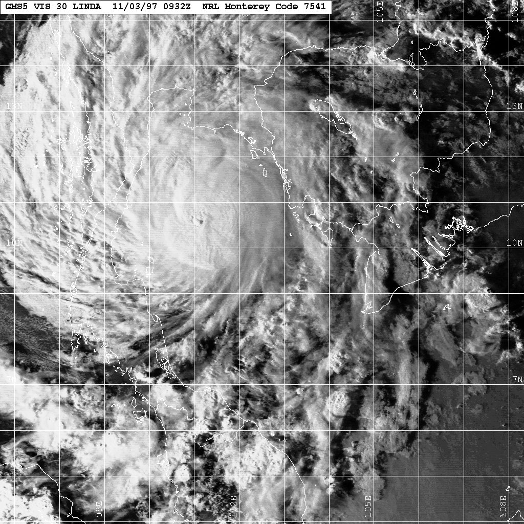
Track=Linda Pacific 1997 track.pngOctober 25
Dissipated=November 9
1-min winds=65
Pressure=976Malay Peninsula onNovember 3 . It restrengthened in the Bay of Bengal, but vertical shear caused Linda to dissipate on the 9th.On the 2nd of November, Linda hit the southern tip of
Vietnam , theCa Mau province , causing unprecedented havoc with over 435 people were reported killed and 3,660 fishermen gone missing [http://vietnamnet.vn/xahoi/2007/11/756065/] . Nearly 80,000 houses are reported as destroyed and almost 140,000 as badly damaged. Infrastructure (roads, schools and hospitals) also suffered heavily and huge swathes of rice paddy were swamped. The hardest hit provinces were Kien Giang, Ca Mau, Bac Lieu, Soc Trang, Tra Vinh, Ben Tre and Vung Tau. It was the worst typhoon to strike the area in 100 years. [http://www.reliefweb.int/rw/rwb.nsf/db900sid/OCHA-64CQJT?OpenDocument]Elsewhere in Thailand and the Philippines , Linda caused further deaths from flooding and heavy damage.Joint Typhoon Warning Center. [https://metocph.nmci.navy.mil/jtwc/atcr/1997atcr/ch3/30w.htm Typhoon Linda (30W).] Retrieved on
2007-01-07 .]Typhoon Mort (Pining)
Infobox Hurricane Small
Basin=WPac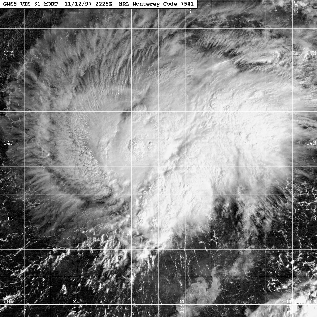
Formed=November 7
Dissipated=November 16
1-min winds=65
Pressure=976
Track=Mort 1997 track.pngFrom November 12-16,Philippine Atmospheric, Geophysical and Astronomical Services Administration tracked the storm, and named it Pining.uper Typhoon Paka (Rubing)
Infobox Hurricane Small
Basin=WPac
Track=Paka 1997 track.pngNovember 28
Dissipated=December 22
1-min winds=160
Pressure=901November 28 . It moved westward, strengthening into a tropical storm before crossing the International Date Line onDecember 7 . Conditions were marginally favorable for development, and Paka remained a tropical storm untilDecember 10 , when it was able to become a typhoon. Five days later, Paka reached Super Typhoon strength, the eleventh of the year. The next day it crossed overGuam , and onDecember 18 , Paka reached a peak of 185 mph winds. After causing major damage across the smaller Western Pacific island groups, Paka rapidly weakened and dissipated onDecember 22 . [Joint Typhoon Warning Center. [https://metocph.nmci.navy.mil/jtwc/atcr/1997atcr/ch3/05cw.htm Super Typhoon Paka (05C).] Retrieved on2007-01-07 .]Accumulated Cyclone Energy (ACE) Ranking
References
ee also
*
1997 Pacific hurricane season
*1997 Atlantic hurricane season
*1997-98 South-West Indian Ocean cyclone season
*1997-98 Australian region cyclone season
*1997-98 South Pacific cyclone season
*1997 North Indian Ocean cyclone season External links
* [http://www.typhoon2000.ph Typhoon2000 Philippine typhoon website] .
* [http://www.typhoon2000.ph/plotting/PhilippineTyphoonChart.gifPhilippine Area of Responsibility] .
* [https://metocph.nmci.navy.mil/jtwc.html Joint Typhoon Warning Center] .
* [http://www.weather.gov.hk/informtc/sound/tc_pronunciatione.htm Meaning of Tokyo Typhoon Centre names] .
Wikimedia Foundation. 2010.