- 1997 Atlantic hurricane season
Infobox hurricane season | name=1997 Atlantic hurricane season
first storm formed=May 31 ,1997 (Subtrop)
last storm dissipated=October 17 ,1997 (Grace)
strongest storm=Erika - 946mbar (27.93inHg ), 110 knots (125 mph)
total storms=8
Total hurricanes=3
major storms=1
total daUSD )
$130 million (2005 USD)
total fatalities=11
basin=Atlantic hurricane
five seasons=1995, 1996, 1997, 1998, 1999 The 1997 Atlantic hurricane season officially began onJune 1 ,1997 , and lasted untilNovember 30 ,1997 . These dates conventionally delimit the period of each year when mosttropical cyclone s form in theAtlantic basin .The 1997 season was inactive, with only seven named storms (eight total) forming. It was the first time since the 1961 season that there were no active tropical cyclones in the Atlantic basin during the entire month of August. A strong
El Niño is credited with reducing the number of storms in the Atlantic, while increasing the number of storms in the1997 Pacific hurricane season and1997 Pacific typhoon season with 19 and 29 storms, respectively. As is common in El Niño years,tropical cyclogenesis was suppressed in the tropical latitudes, with only two becoming tropical storms south of 25°N.Hurricane Danny killed four people, and caused an estimated $100 million in damage when it made landfall near the mouth of the
Mississippi River . Hurricane Erika, the strongest storm of the season, passed within convert|85|mi|km of theLesser Antilles , far enough away to prevent hurricane conditions from reaching land. No land effects were felt by One, Ana, Bill, Claudette, Tropical Depression Five, Fabian and Grace.Storms
ubtropical Storm One
Infobox Hurricane Small
Basin=Atl
.jpg)
Type=subtropical
Formed=May 31
Dissipated=June 2
1-min winds=45
Pressure=1003A cluster of thunderstorms developed overFlorida in late May. A shortwave trough brought it to the northeast, enhancing convection around a developing center of circulation. The low pressure area, which formed onMay 31 , developed into a subtropical depression onJune 1 . It reached subtropical storm strength 6 hours later as it moved rapidly parallel to theEast Coast of the United States . The convection continued to wrap around the center, and despite unfavorable conditions from an approaching cold front, it reached a peak of convert|50|mi/h|km/h|abbr=on late onJune 1 while off the coast ofNorth Carolina .cite web|url=http://www.nhc.noaa.gov/1997st01.html|title=Preliminary Report - Unnumbered Subtropical Storm|author=Jack Beven and Max Mayfield|date=November 12 ,1997 |accessdate=2008-05-14|publisher=National Hurricane Center ]The storm turned to the east, and became extratropical late on
June 2 while southeast ofMassachusetts as it was merged by a cold front. Operationally, it was treated as a frontal low, but post-analysis suggested it remained separate throughout its lifetime, and was classified as an unnamed subtropical storm.Tropical Storm Ana
Infobox Hurricane Small
Basin=Atl
.jpg)
Track=Ana 1997 track.pngJune 30
Dissipated=July 04
1-min winds=45
Pressure=1000South Carolina developed into Tropical Depression One onJune 30 . It moved slowly eastward, and attained tropical storm status onJuly 1 . After peaking at convert|45|mi/h|km/h|abbr=on, a shortwave trough brought Ana to the northeast, where vertical shear caused the storm to lose what little convection it had. Ana weakened to a tropical depression on the 3rd, and became extratropical on the 4th over the western Atlantic Ocean. There were no damages reported and Ana never affected land.Hurricane Bill
Infobox Hurricane Small
Basin=Atl
.jpg)
Track=Bill 1997 track.pngJuly 11
Dissipated=July 13
1-min winds=65
Pressure=986Puerto Rico . Convection increased over a low level trough, and as the upper level moved southwestward, upper level shear weakened greatly. This allowed for a center organize within the convection, and was classified a tropical depression near theBahamas onJuly 11 . Though it had a high pressure of 1013mb, the system was in an area of higher pressures, and it reached tropical storm strength later on the 11th under favorable conditions. Embedded within the westerlies, Bill moved quickly to the northeast and reached hurricane status on the 12th over progressively cooler waters, defying forecasts of its demise. The cool waters weakened Bill to a tropical storm onJuly 13 , and it was absorbed by a front later that day. A tropical storm warning was issued for Bermuda, but Bill passed the island without incident.Tropical Storm Claudette
Infobox Hurricane Small
Basin=Atl
.jpg)
Track=Claudette 1997 track.pngJuly 13
Dissipated=July 16
1-min winds=40
Pressure=1003South Carolina onJuly 11 . It drifted eastward, and slowly acquired tropical characteristics. A low-level circulation developed, and the system became Tropical Depression Three on the 13th while convert|315|mi|km south-southeast ofCape Hatteras, North Carolina . Convection continued to organize around the center, and the depression strengthened into Tropical Storm Claudette later on the 13th. After reaching a peak of convert|45|mi/h|km/h|abbr=on winds, the storm encountered southwesterly upper-level shear from an upper-level low. The storm struggled to maintain its intensity as it moved to the northeast. Easterly flow from an approaching frontal boundary turned Claudette to the east, where it weakened into a tropical depression on the 16th. The storm briefly re-strengthened into a tropical storm, but merged with the cold front later on the 16th. As a frontal low, the extratropical storm persisted until dissipating near theAzores islands onJuly 23 . [http://www.nhc.noaa.gov/1997claudett.html]The storm caused severe rip currents in
Connecticut , causing one serious injury. [http://maestro.srcc.lsu.edu/softlib/sd/sd9707.pdf]Hurricane Danny
Infobox Hurricane Small
Basin=Atl
Track=Danny 1997 track.pngJuly 16
Dissipated=July 26
1-min winds=70
Pressure=984Gulf of Mexico in mid July. OnJuly 17 , this low had strengthened into Tropical Storm Danny. Danny moved east-northeast, and reached hurricane strength just before landfall nearBuras, Louisiana . Because of the narrowness of that piece of land, most of Danny remained over water and it lost little strength, and made landfall nearMullet Point, Alabama onJuly 19 . After stalling for a day, Danny moved northward and weakened to a tropical depression. The depression headed north acrossAlabama , then turned to the east and emerged over theAtlantic Ocean near theNorth Carolina /Virginia border onJuly 24 . The depression immediately restrengthened into a tropical storm. Danny took a northward turn, and came within 25 n mi ofNantucket Island onJuly 26 . It then turned out to sea and was absorbed by a front onJuly 27 . Hurricane Danny caused four direct deaths, and $100 million in estimated damages.Tropical Depression Five
Infobox Hurricane Small
Basin=Atl
.jpg)
Formed=July 16
Dissipated=July 26
1-min winds=30
Pressure=1008Tropical Depression Five formed from a tropical wave that emerged from the west coast of Africa onJuly 11 . The wave moved westward across the tropical Atlantic, and finally began to show consistent evidence of a cloud system center. Deep convection associated with the wave became concentrated on satellite images onJuly 17 , and it is estimated that the disturbance became Tropical Depression Five around 0600 UTC on this day while centered about convert|475|nmi|km east ofBarbados .The tropical depression moved west-northwestward and started showing signs of falling apart on
July 18 . Early onJuly 19 it degenerated intotropical wave . Recon observations before the storm fell apart suggested that it may have briefly reached tropical storm strength. The tropical wave continued westward without regenerating and lost its identity onJuly 23 over the easternGulf of Mexico .Hurricane Erika
Infobox Hurricane Small
Basin=Atl

Track=Erika 1997 track.pngSeptember 3
Dissipated=September 20
1-min winds=110
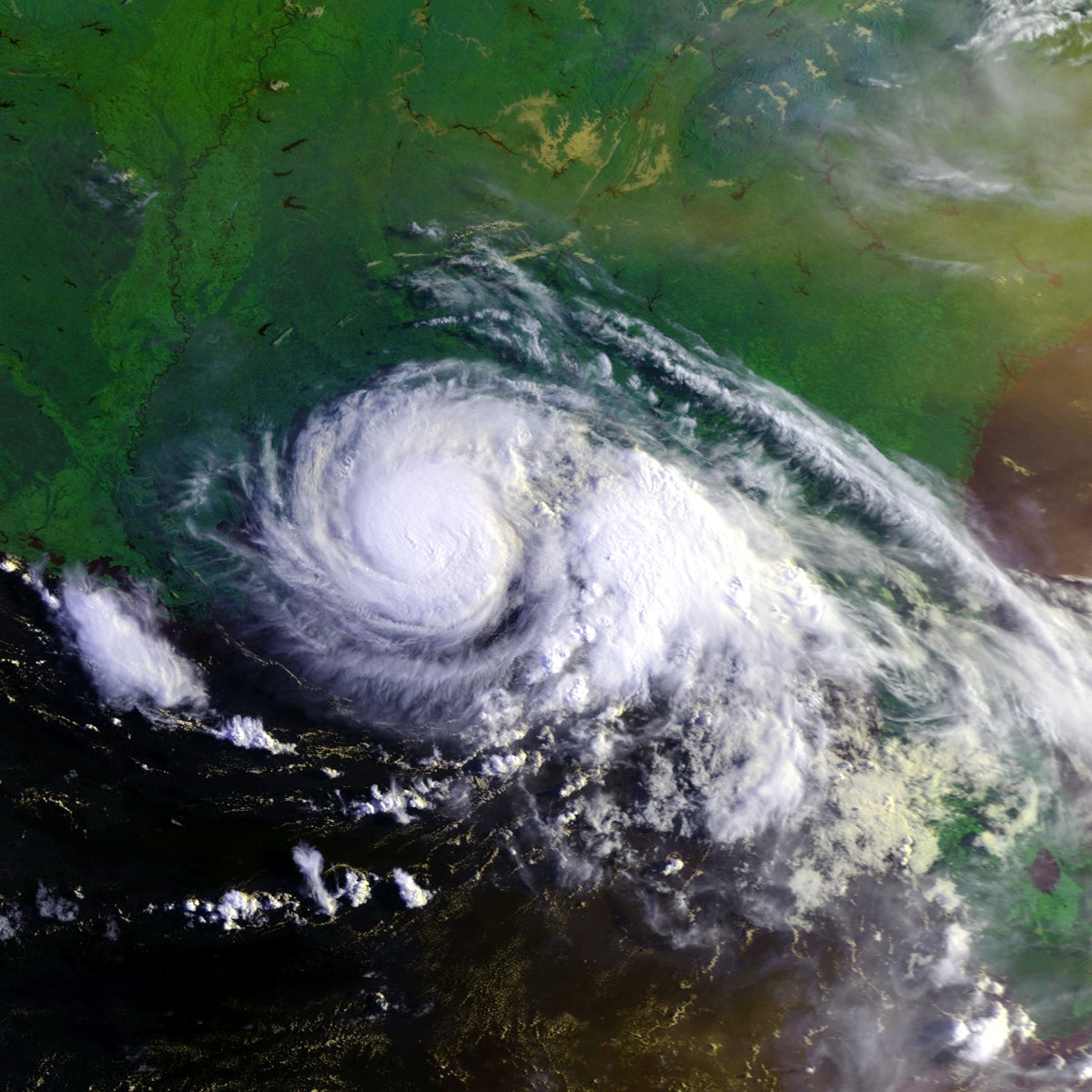
Pressure=946tropical wave onSeptember 3 . It moved west-northwestward, and steadily intensified to attain hurricane status onSeptember 4 . Erika passed a short distance to the north of theLesser Antilles , and later turned to the north in response to an approaching trough. The hurricane quickly strengthen to reach peak winds of 125 mph (195 km/h) onSeptember 8 , and after maintaining peak strength for 24 hours Erika weakened over cooler waters. It turned to the east, weakened to a tropical storm, and became extratropical after passing near theAzores islands.cite web|author=Miles B. Lawrence|year=1997|title=Hurricane Erika Tropical Cyclone Report|publisher=National Hurricane Center|accessdate=2006-12-31|url=http://www.nhc.noaa.gov/1997erika.html]The hurricane produced light rainfall and winds throughout the northern
Lesser Antilles .cite web|author=Stormcarib.com|year=1997|title=Unofficial Reports from the Caribbean Sea on Hurricane Erika|accessdate=2006-12-31|url=http://www.stormcarib.com/hurr97b.htm#TD6] The passage of Erika brought a cloud of ash toAntigua from the eruption of the Soufrière Hills Volcano onMontserrat , a rare occurrence. Strong waves from the hurricane produced beach erosion and coastal flooding in northernPuerto Rico , and also killed two surfers. Moderate wind gusts in Puerto Rico left thousands without power,cite web|author=National Climatic Data Center|year=1997|title=Event Report for Puerto Rico|accessdate=2006-12-31|url=http://www4.ncdc.noaa.gov/cgi-win/wwcgi.dll?wwevent~ShowEvent~315259] and the hurricane resulted in $10 million (1997 USD, $12.6 million 2006 USD) in damage in the Caribbean territory of theUnited States .cite web|author=Usatoday.com|year=1997|title=Erika swipes Caribbean, hits Azores|accessdate=2006-12-31|url=http://www.usatoday.com/weather/werika.htm] Erika also produced gusty winds and light rain in the Azores. Erika was the only tropical cyclone in theAtlantic Ocean in the months of August and September, the first such occurrence in a hurricane season since 1929.cite web|author=Lawrence|year=1997|title=September Monthly Tropical Weather Summary|publisher=National Hurricane Center|accessdate=2006-12-31|url=http://mpittweather.com/txt/sept97atl.txt|format=TXT]Tropical Storm Fabian
Infobox Hurricane Small
Basin=Atl
.jpg)
Track=Fabian 1997 track.pngOctober 5
Dissipated=October 8
1-min winds=35
Pressure=1004October 5 . It moved northeast and became extratropical onOctober 8 . No damage is directly associated with Fabian. Heavy rains over the Lesser Antilles could have caused some minor damage.Tropical Storm Grace
Infobox Hurricane Small
Basin=Atl
.jpg)
Track=Grace 1997 track.pngOctober 16
Dissipated=October 17
1-min winds=40
Pressure=999Hispaniola onOctober 15 , and the next day gained enough tropical characteristics to be classified as a tropical storm. It moved east-northeast until it was absorbed by another system onOctober 17 . Tropical Storm Grace caused no reported damage.The precursor disturbance dropped heavy rainfall across
Puerto Rico , peaking at 12.69 inches in Aibonito. [http://www.hpc.ncep.noaa.gov/tropical/rain/grace1997.html]Accumulated Cyclone Energy (ACE) Rating
The table on the right shows the ACE for each storm in the season. The ACE is, broadly speaking, a measure of the power of the hurricane multiplied by the length of time it existed for, so hurricanes that lasted a long time have higher ACEs (such as Erika). The 1997 season had a below average ACE of 40.085, the lowest total since 1994, which only had 31.53 in ACE.
Storm names
The following names were used for named storms that formed in the north Atlantic in 1997. No names were retired, so it was used again in the 2003 season. This is the same list used for the 1991 season except for Bill, which replaced Bob. A storm was named Bill for the first time in 1997. Names that were not assigned are marked in tcname unused.
Retirement
The
World Meteorological Organization retired no names used in the 1997 season.ee also
*
List of Atlantic hurricanes
*List of Atlantic hurricane seasons
*1997 Pacific hurricane season
*1997 Pacific typhoon season
*1997 North Indian Ocean cyclone season
*South-West Indian Ocean cyclone seasons: 1996–97, 1997–98
*Australian region cyclone seasons: 1996–97, 1997–98
*South Pacific cyclone seasons: 1996–97, 1997–98References
External links
* [http://www.aoml.noaa.gov/general/lib/lib1/nhclib/mwreviews/1997.pdf Monthly Weather Review]
* [http://www.nhc.noaa.gov/1997.html National Hurricane Center 1997 Atlantic hurricane season summary]

Wikimedia Foundation. 2010.